
| Woodrow Wilson Bridge Project Photos - November 2006 |
The following 58 photos show various aerial views of the I-95/I-495 Woodrow Wilson Bridge (WWB) Project construction, including the new Potomac River Bridge construction, the Virginia U.S. Route 1 Interchange construction, the Washington Street Urban Deck construction, and the Maryland Interstate 295 Interchange construction.
These photos were taken on November 17, 2006 by the Virginia Department of Transportation, and are posted here with their permission. Roads to the Future utilized PhotoDeluxe Business Edition to sharpen and brighten and to align all of the photos. Click on the photo to get a large version of the photo. In later versions of Netscape and Internet Explorer, you probably will need to use Full Screen mode (the F11 key can be utilized to swap back and forth between Full Screen and Regular) to see the full size of the large photo without browser-induced image shrinkage. The large photos have sizes ranging from 124 to 268 kilobytes, with most of them being under 198 kilobytes. The photos marked "LARGE PHOTO" are much larger, with a very detailed zoom-in of the previous photo, and they have the file size listed next to the photo. With a broadband or network Internet connection each photo will download within seconds, but with a dial-up Internet connection it will be somewhat slower.
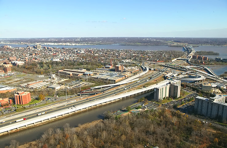 |
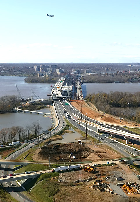
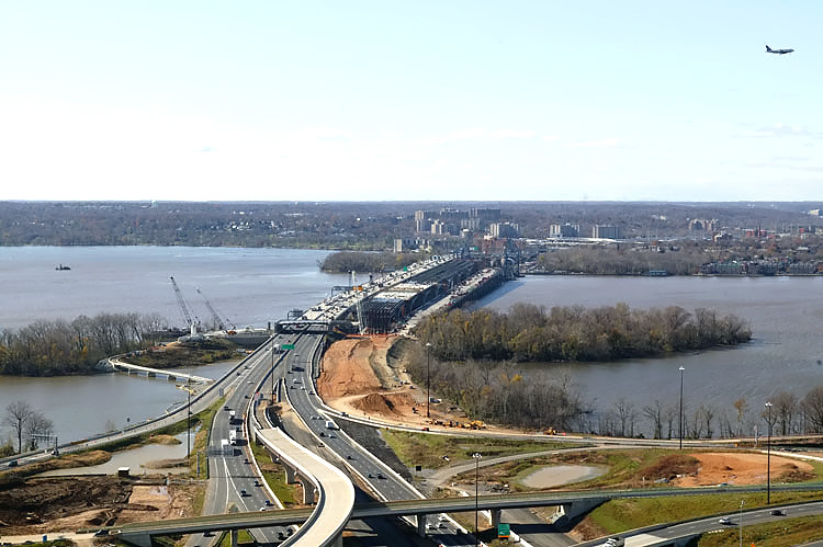
The I-95/I-495 Capital Beltway runs lower left to upper right, Hunting Creek is just to the right of the Beltway, the Potomac River is in the upper part of the photo, the U.S. Route 1 Interchange construction is in the upper right part of the photo, and the Woodrow Wilson Bridge is in the upper right of the photo. Alexandria, Virginia is on the north side of (above) the Beltway. Virginia is on this side of the Potomac River, and Maryland and Washington, D.C. is on the opposite side of the river. |
 |
U.S. Route 1 Interchange construction, looking north across Hunting Creek and the I-95/I-495 Capital Beltway, with Alexandria on the north side of the Beltway. |
 |
U.S. Route 1 Interchange construction, looking north across Hunting Creek and the I-95/I-495 Capital Beltway, with Alexandria on the north side of the Beltway. |
 |
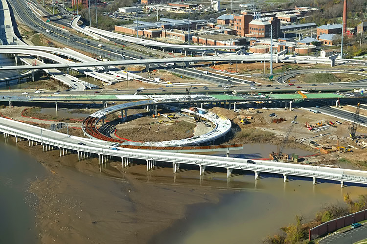
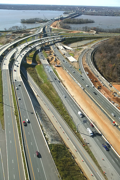
U.S. Route 1 Interchange construction, looking north across Hunting Creek and the I-95/I-495 Capital Beltway, with Alexandria on the north side of the Beltway. The Beltway runs left to right, and US-1 runs from lower left to the upper middle. Notice the new 3-lane northbound US-1 bridge under construction, which passes over Hunting Creek, low-lying land, and the Beltway. Notice the loop ramp under construction from the Beltway Outer Loop (to WWB) to northbound US-1. |
 |
U.S. Route 1 Interchange construction, looking north across Hunting Creek and the I-95/I-495 Capital Beltway, with Alexandria on the north side of the Beltway. Old Town Alexandria is in the upper part of the photo. |
 |
U.S. Route 1 Interchange construction, looking northwest across Hunting Creek and the I-95/I-495 Capital Beltway, with Alexandria on the north side of the Beltway. |
 |
U.S. Route 1 Interchange construction, looking northwest across Hunting Creek and the I-95/I-495 Capital Beltway, with Alexandria on the north side of the Beltway. |
 |
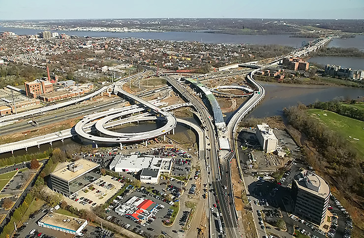
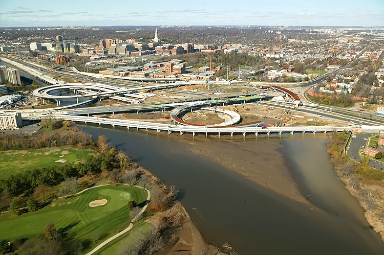
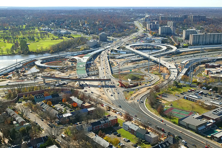
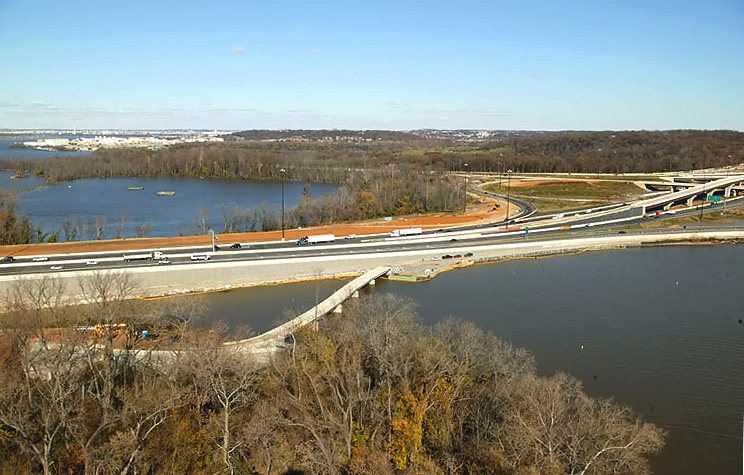
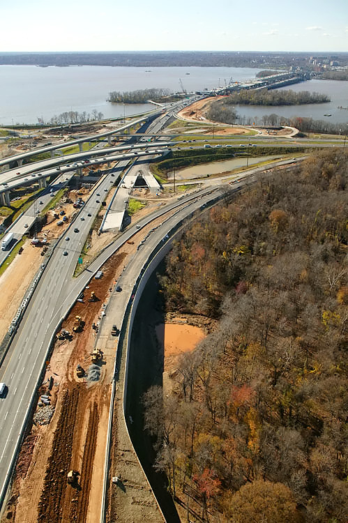
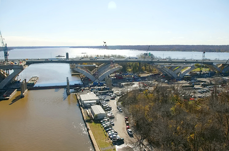
U.S. Route 1 Interchange construction, looking west across Hunting Creek and the I-95/I-495 Capital Beltway, with Alexandria on the north side of the Beltway. The Beltway heads west into the distance in the upper left of the photo. |
 |
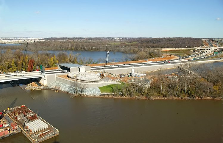
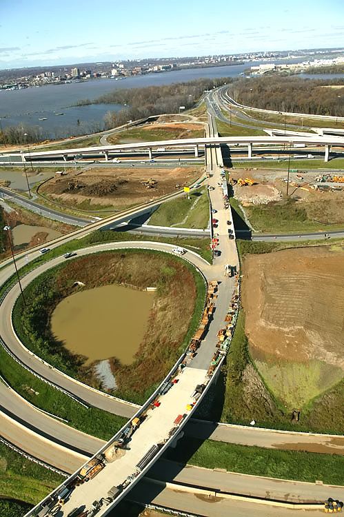
U.S. Route 1 Interchange construction, looking west across Hunting Creek, and the I-95/I-495 Capital Beltway, with Alexandria on the north side of the Beltway. The Washington Street Urban Deck is under construction in the lower right of the photo. |
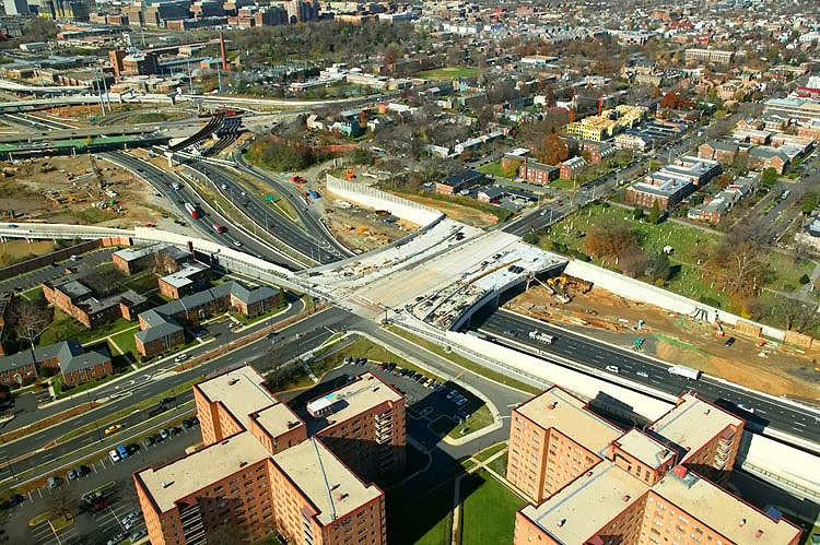 |
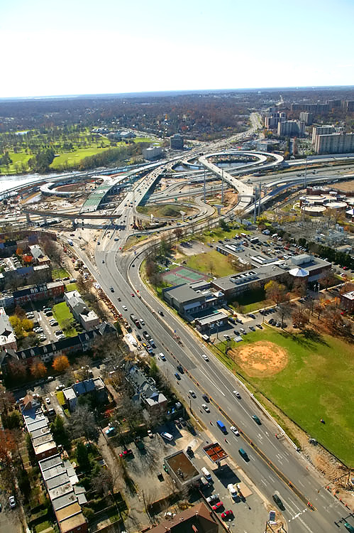
The Washington Street Urban Deck is under construction in the center of the photo. The Washington Street Urban Deck is over 200 feet wide, will be landscaped, and will remove the 'barrier effect' to pedestrians that would exist with a simple replacement of the 4-lane Washington Street overpass over the 12-lane Beltway. |
 |
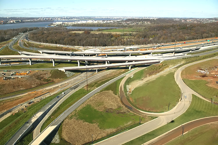
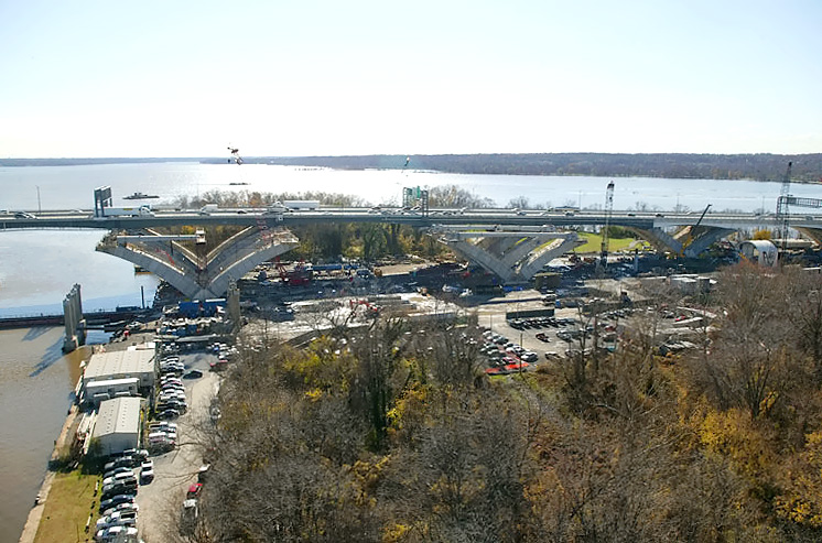
Looking west along the Beltway, showing construction of the Washington Street Urban Deck in Alexandria VA, and the U.S. Route 1 Interchange in the distance. The Washington Street Urban Deck has been completed over the future local and express Beltway Outer Loop roadways, with Beltway traffic operating there; and it is under construction over the future local and express Beltway Inner Loop roadways. |
 |
Looking west along the Beltway, showing construction of the Washington Street Urban Deck in Alexandria VA, and the U.S. Route 1 Interchange in the distance. |
 |
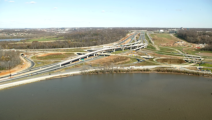
U.S. Route 1 Interchange construction, looking south along U.S. Route 1 which goes into the distance in the upper left, with the Beltway running lower left to upper right. |
 |
U.S. Route 1 Interchange construction, looking south along U.S. Route 1 which goes into the distance, with the Beltway running left-right. |
 |
U.S. Route 1 Interchange construction, looking south along U.S. Route 1 which goes into the distance, with the Beltway running left-right. |
 |
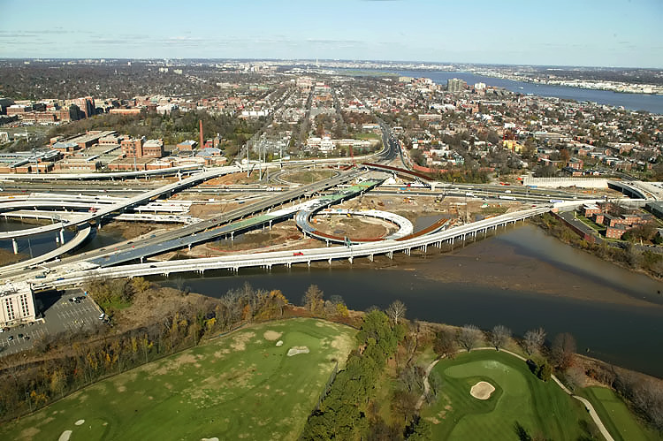
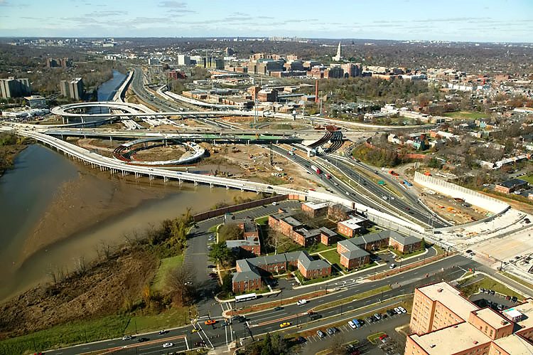
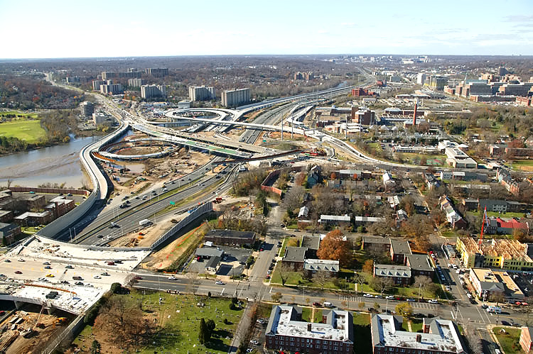
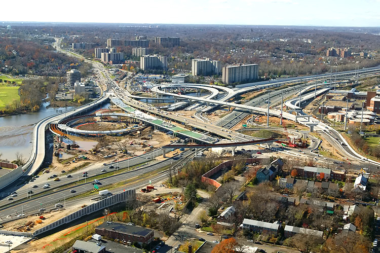
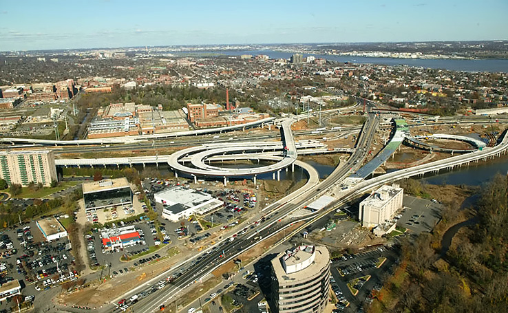
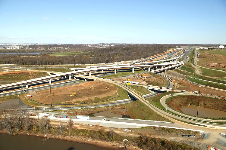
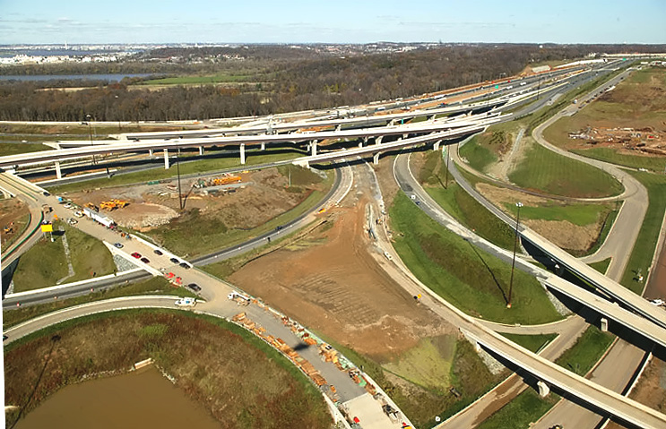
The 8-lane I-95/I-495 Capital Beltway runs bottom to top, Hunting Creek (also known as Cameron Run) is just to the right of the Beltway, the Potomac River is in the upper part of the photo, the U.S. Route 1 Interchange construction is in the upper part of the photo. Notice the elevated ramps under construction in the lower left of the photo, they are part of the local ramps that will connect the Eisenhower Valley in Alexandria, Virginia, to the Beltway's traffic to and from Maryland. |
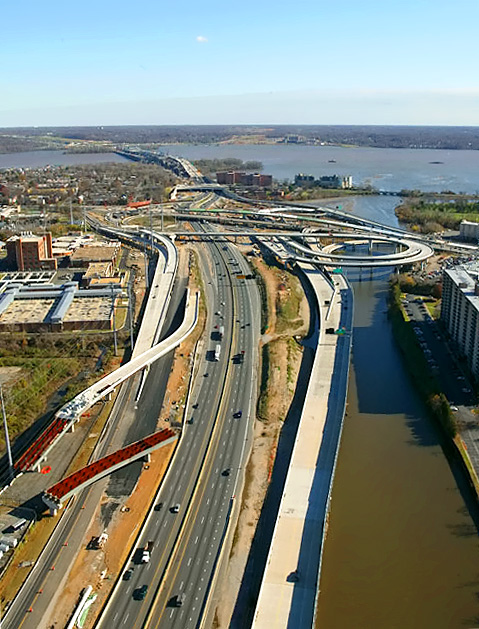 |
The 8-lane I-95/I-495 Capital Beltway runs bottom to top, Hunting Creek (also known as Cameron Run) is just to the right of the Beltway, the Potomac River is in the upper part of the photo, the U.S. Route 1 Interchange construction is in the upper part of the photo, and the Woodrow Wilson Bridge is in the upper part of the photo. Notice the elevated ramps under construction in the lower left of the photo, they are part of the local ramps that will connect the Eisenhower Valley in Alexandria, Virginia, to the Beltway's traffic to and from Maryland. The long new bridge on the right side of the Beltway, is part of the completed US Route 1 Interchange Advanced Bridge contract, and the bridge will carry the Beltway Outer Loop local roadway; currently it is carrying local traffic exiting the Beltway to US-1. |
 |
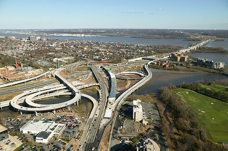
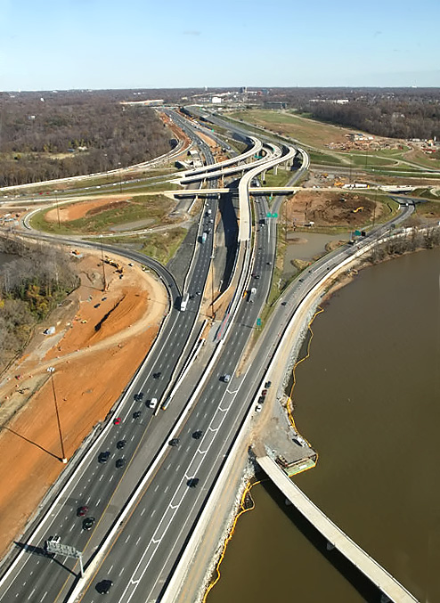
U.S. Route 1 Interchange construction, looking east along the I-95/I-495 Capital Beltway, with Alexandria on the north side of the Beltway, and the Potomac River, the Woodrow Wilson Bridge, and Maryland, visible in the distance. |
 |
U.S. Route 1 Interchange construction, looking east along the I-95/I-495 Capital Beltway, with Alexandria on the north side of the Beltway, the Washington Street Urban Deck, the Potomac River, the Woodrow Wilson Bridge, and Maryland, visible in the distance. |
 |
U.S. Route 1 Interchange construction, looking east along the I-95/I-495 Capital Beltway, with Alexandria on the north side of the Beltway, the Washington Street Urban Deck, the Potomac River, the Woodrow Wilson Bridge, and Maryland, visible in the distance. |
 |
U.S. Route 1 Interchange construction, looking north across Hunting Creek and the I-95/I-495 Capital Beltway, with Alexandria on the north side of the Beltway. |
 |
U.S. Route 1 Interchange construction, looking north across Hunting Creek, and the I-95/I-495 Capital Beltway, with Alexandria on the north side of the Beltway. The Woodrow Wilson Bridge is off of the photo to the right. The new ramp from US-1 northbound to the Outer Loop of the Beltway, can be seen in the foreground of the photo, and this bridged ramp has a separate pedestrian/bicycle trail on the east side of the bridge, and the trail carries pedestrian/bicycle traffic between US-1 south of Alexandria and Washington Street and the pedestrian/bicycle trail which will cross the Potomac River on the new Woodrow Wilson Bridge to pedestrian/bicycle trails in Maryland. |
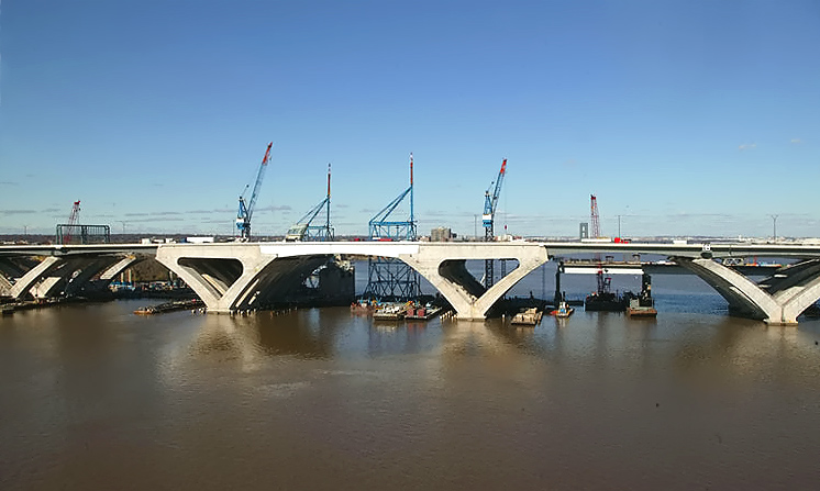 |
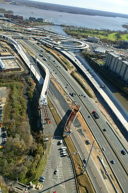
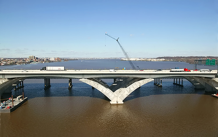
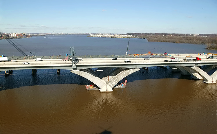
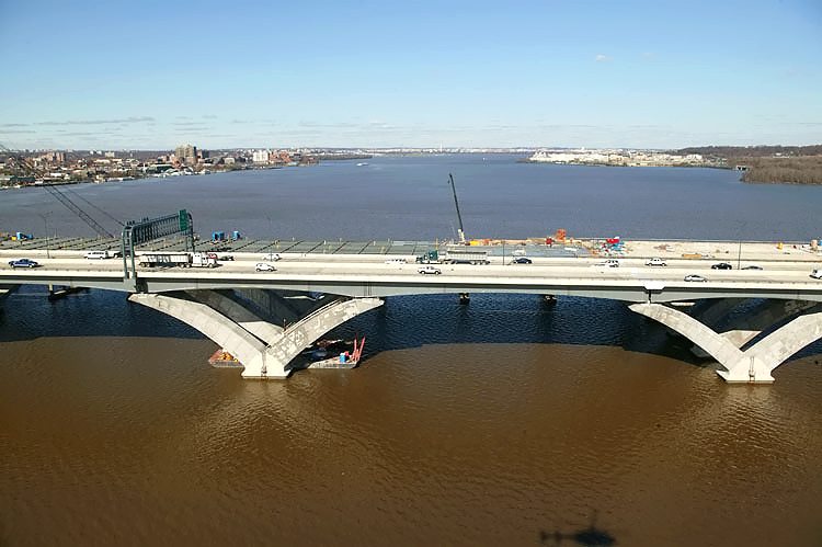
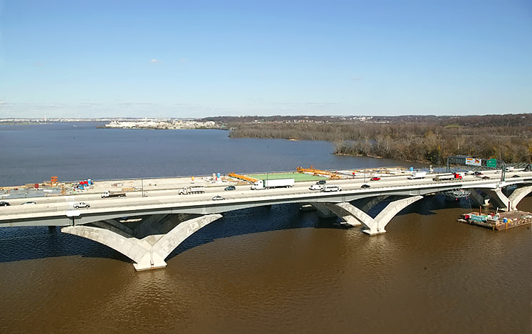
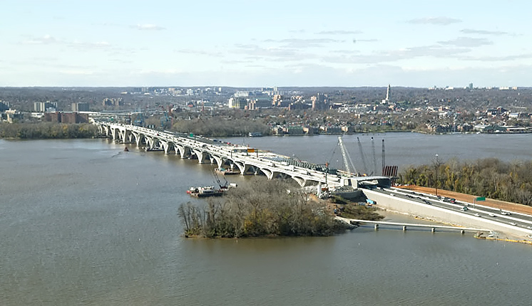
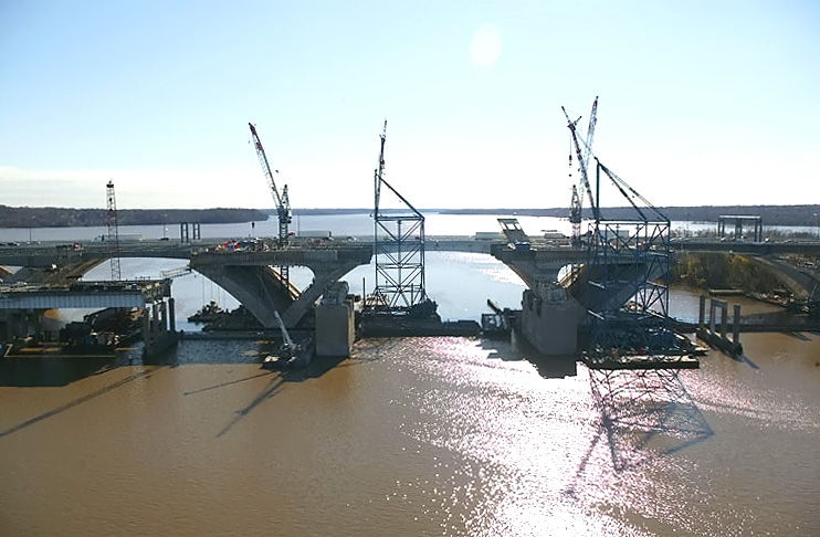
Potomac River Bridge construction, view of the Bascule Span construction, which is being built under the Potomac River Bridge Bascule Spans contract. The 6-lane new bridge for the Outer Loop was opened to traffic in June and July, 2006, and the second new bridge is under construction. The original Woodrow Wilson Bridge is behind the bridge under construction. The new bascule span has 70 feet of vertical navigational clearance when the drawspan is closed, 20 feet higher than the original bridge's bascule span which had 50 feet of vertical navigational clearance when its drawspan was closed. |
 |
Potomac River Bridge construction, view of the Maryland Approach Spans construction. Downtown Washington, D.C. is in the distance. |
 |
Potomac River Bridge construction, view of the Maryland Approach Spans construction. |
 |
Potomac River Bridge construction, view of the Maryland Approach Spans construction. Notice the Beltway traffic on the near-side new bridge. |
 |
Potomac River Bridge construction, view of the Maryland Approach Spans construction. Notice the Beltway traffic on the near-side new bridge. |
 |
Potomac River Bridge construction, view of the Maryland Approach Spans construction. The Maryland abutment (terminal structure) for the new Potomac River Bridge is visible in the right of the photo. Interstate 295 Interchange construction, is to the right. |
 |
Potomac River Bridge construction, view of the Maryland Approach Spans construction. The Maryland abutment (terminal structure) of the new Potomac River Bridge is visible in the left of the photo, on Rosalie Island. Interstate 295 Interchange construction, is to the right. |
 |
Land Beltway roadway construction, between Rosalie Island and the Maryland mainland. Interstate 295 Interchange construction, is to the right. Notice the pedestrian bridge under construction between Rosalie Island and the Maryland mainland. There will be a separate pedestrian/bicycle trail on the north side of the second new Woodrow Wilson Bridge, and the trail will carry pedestrian/bicycle traffic between US-1 south of Alexandria and pedestrian/bicycle trails in Maryland. |
 |
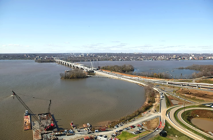
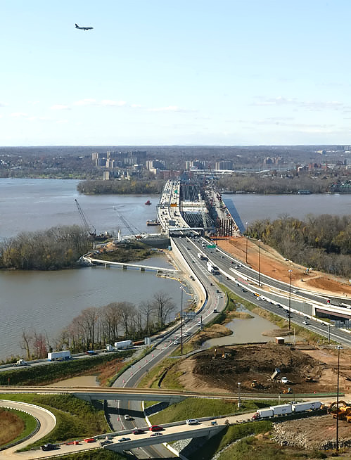
Interstate 295 Interchange construction, looking east, the Potomac River Bridge is just off of the left edge of the photo, and the I-95/I-495 Beltway sweeps into the distance, with I-295 curving left to right as it extends to MD-210 Indian Head Highway in the distance. |
 |
Interstate 295 Interchange construction, looking northeast. High capacity
roadways and ramps are being constructed to make this a 4-way interchange,
with the southerly extension heading into the National Harbor development
to the right which began construction in 2004. Website for National Harbor. |
 |
Interstate 295 Interchange construction, looking north. |
 |
Interstate 295 Interchange construction, looking north. |
 |
Interstate 295 Interchange construction, looking north. I-295 heads north into the distance to downtown Washington, D.C. |
 |
Interstate 295 Interchange construction, looking west along the I-95/I-495 Beltway. The Woodrow Wilson Bridge across the Potomac River is in the upper center part of the photo. I-295 curves over the Beltway on the two new bridges to the right, and I-295 terminates at MD-210 Indian Head Highway about a mile to the east. The two new bridges to the left are ramps connecting the Beltway Outer Loop to I-295. |
 |
Interstate 295 Interchange construction in Maryland, looking west toward Virginia, along the I-95/I-495 Beltway. |
 |
Interstate 295 Interchange construction, looking west along the I-95/I-495 Beltway. The Woodrow Wilson Bridge across the Potomac River is in the upper right part of the photo, with the old WWB to the right and the new WWB to the left, and Virginia is on the opposite side of the Potomac River. |
 |
Interstate 295 Interchange construction, looking south. High capacity roadways and ramps are being constructed to make this a 4-way interchange, with the southerly extension heading into the National Harbor development which began construction in 2004, and whose grading and site preparation can be seen in the distance. Website for National Harbor. |
 |
Interstate 295 Interchange construction, looking east along the I-95/I-495 Beltway, the Potomac River Bridge is just off of the bottom edge of the photo. In the lower half of the photo is land Beltway roadway construction, between Rosalie Island and the Maryland mainland. |
 |
Woodrow Wilson Bridge construction, looking west. Virginia and Old Town Alexandria is on the opposite side of the Potomac River, and Maryland is on the near side of the river. |
 |
Woodrow Wilson Bridge construction, looking west. Virginia and Old Town
Alexandria is on the
opposite side of the Potomac River, and Maryland is on the near side of
the river. This is a zoom-in excerpt
of the previous photo, with a size of 703 kilobytes. |
 |
Interstate 295 Interchange and Woodrow Wilson Bridge construction, looking west. |
 |
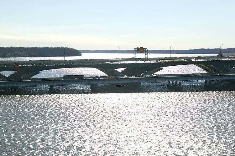
Interstate 295 Interchange and Woodrow Wilson Bridge construction, looking west, with the old closed WWB to the right, the new 6-lane WWB to the left, and the under construction second new 6-lane WWB in the center. |
 |
Woodrow Wilson Bridge construction, looking
west, with the old closed WWB to the right, the new 6-lane WWB to the
left, and the under construction second new 6-lane WWB in the center.
Virginia and Old Town Alexandria is on the opposite side of the Potomac
River, and Maryland is on the near side of the river.
This is a zoom-in excerpt of the previous photo, with a size of 664 kilobytes. LARGE PHOTO |
 |
Interstate 295 Interchange and Woodrow Wilson Bridge construction, looking
west, with the old closed WWB to the right, the new 6-lane WWB to the
left, and the under construction second new 6-lane WWB in the center.
Notice the airliner heading north on its final approach to National Airport about 3 miles to the north. |
 |
Woodrow Wilson Bridge construction, looking
west, with the old closed WWB to the right, the new 6-lane WWB to the
left, and the under construction second new 6-lane WWB in the center.
Virginia and Old Town Alexandria is on the opposite side of the Potomac
River, and Maryland is on the near side of the river. This is a zoom-in excerpt of the previous photo, with a size of 552 kilobytes. LARGE PHOTO |
 |
Interstate 295 Interchange and Woodrow Wilson Bridge construction, looking west, with the old closed WWB to the right, the new 6-lane WWB to the left, and the under construction second new 6-lane WWB in the center. |
 |
Interstate 295 Interchange and Woodrow Wilson Bridge construction, looking west, with the old closed WWB to the right, the new 6-lane WWB to the left, and the under construction second new 6-lane WWB in the center. |
 |
Woodrow Wilson Bridge construction, looking
west, with the old closed WWB to the right, the new 6-lane WWB to the
left, and the under construction second new 6-lane WWB in the center.
Virginia and Old Town Alexandria is on the opposite side of the Potomac
River, and Maryland is on the near side of the river. This is a zoom-in excerpt of the previous photo, with a size of 498 kilobytes. LARGE PHOTO |
 |
Potomac River Bridge construction, looking south, view of the Potomac River Bridge Maryland Approach Spans contract construction, near the Maryland shoreline. |
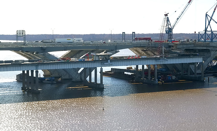 |
Potomac River Bridge construction, looking south, view of the Maryland
Approach Spans construction.
The old closed 6-lane Woodrow Wilson Bridge is visible on the near side of the new bridge construction. Notice the Beltway traffic on the opposite-side new bridge. |
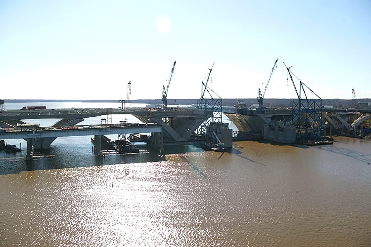 |
Potomac River Bridge construction, looking south, view of the Maryland Approach Spans construction and Bascule Spans construction. |
 |
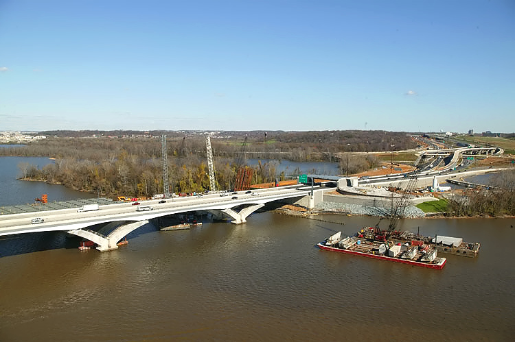
Potomac River Bridge construction, view of the Bascule Span construction, which is being built under the Potomac River Bridge Bascule Spans contract. The new 6-lane WWB is behind the bridge under construction. The old bridge's bascule piers are visible in the foreground, soon to be demolished. |
 |
Construction in the center of the photo is the Potomac River Bridge Virginia Approach Spans contract. Jones Point is visible in the upper center of the photo. The Potomac River heads to the south in the distance. |
 |
Construction in the center of the photo is the Virginia Approach Spans construction. Jones Point is visible in the upper center of the photo. The Potomac River heads to the south in the distance. |
 |
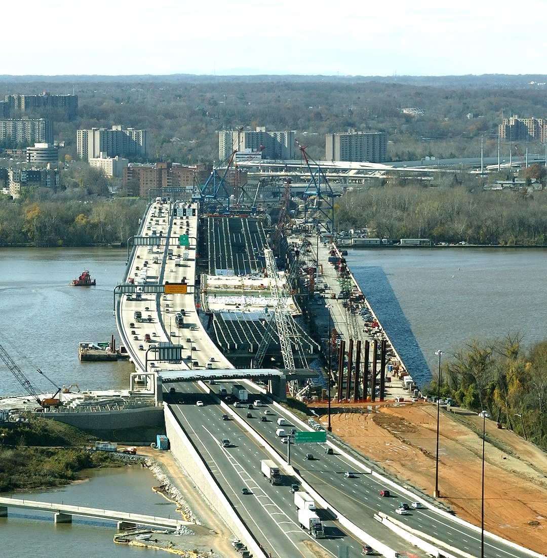
U.S. Route 1 Interchange construction in Virginia, looking south across Hunting Creek and the I-95/I-495 Capital Beltway. The Beltway runs left to right, and US-1 runs from lower right to the upper right. Notice the new 3-lane northbound US-1 bridge under construction, which passes over Hunting Creek, low-lying land, and the Beltway. Notice the bridged loop ramp under construction from the Beltway Outer Loop (to WWB) to northbound US-1. |
 |
U.S. Route 1 Interchange construction, looking south across Hunting Creek and the I-95/I-495 Capital Beltway. The Beltway runs left to right, and US-1 runs from lower right to the upper right. Notice the new 3-lane northbound US-1 bridge under construction, which passes over Hunting Creek, low-lying land, and the Beltway. Notice the bridged loop ramp under construction from the Beltway Outer Loop (to WWB) to northbound US-1. |
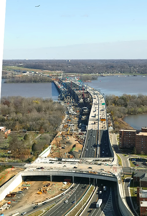 |
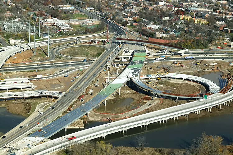
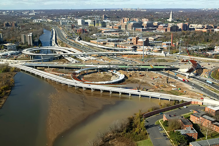
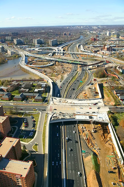
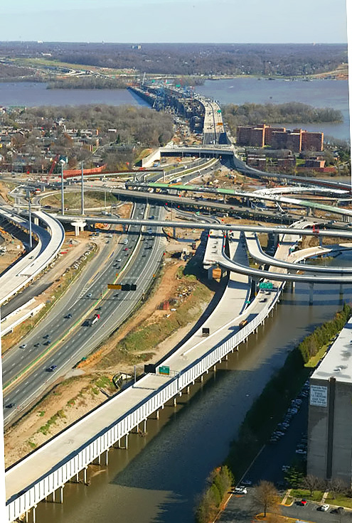
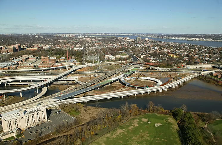
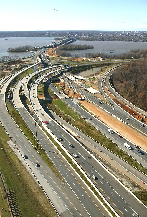
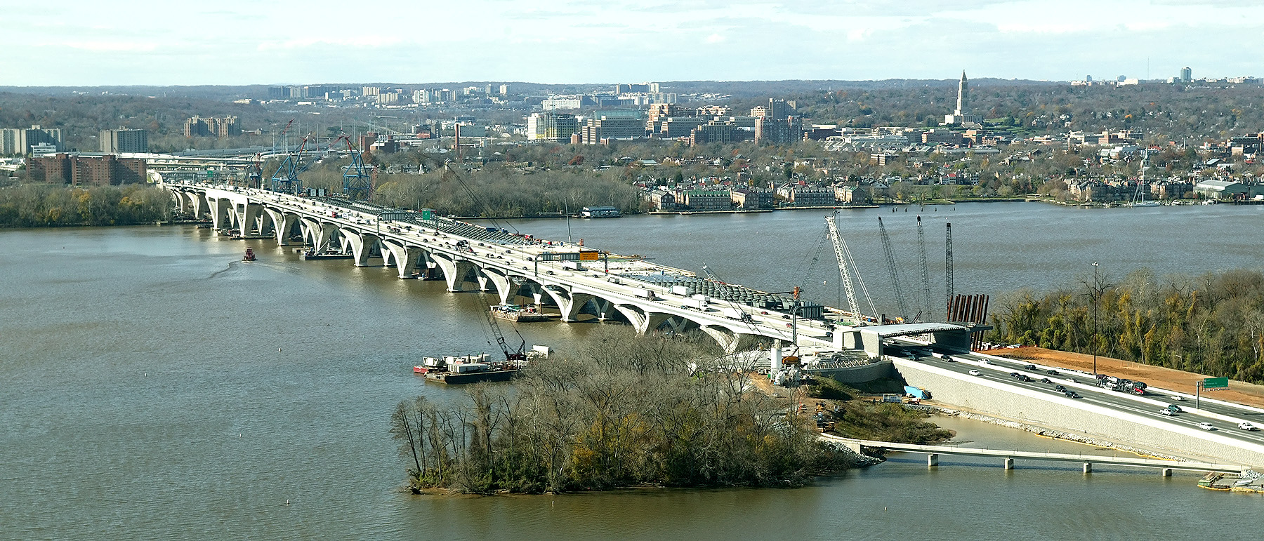
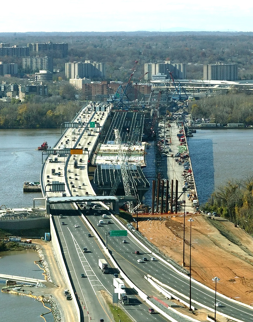
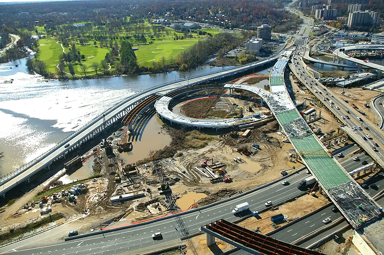
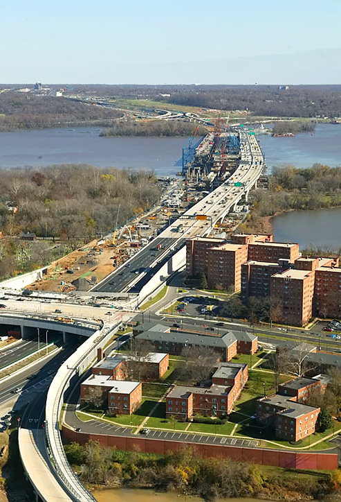
Looking eastward along the Beltway, from above the US-1 interchange in Virginia; and visible in the distance are the Woodrow Wilson Bridge, Potomac River and Maryland. The original WWB which is being demolished is to the left and the new 6-lane WWB is to the right, and the under construction second new 6-lane WWB is in the middle. In the lower part of the photo, the Washington Street Urban Deck has been completed over the future local and express Beltway Outer Loop roadways, with Beltway traffic operating there; and it is under construction over the future local and express Beltway Inner Loop roadways. |
 |
This
is a large version of the previous photo, with a size of 676 kilobytes. LARGE PHOTO |
 |
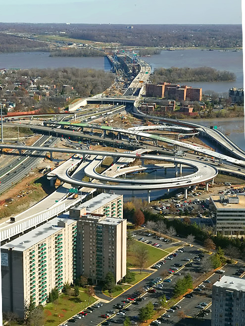
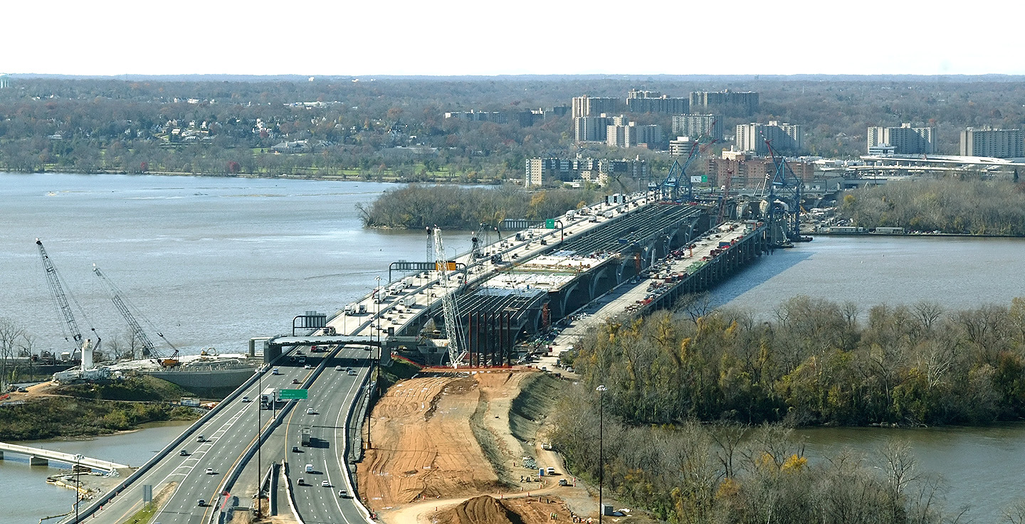
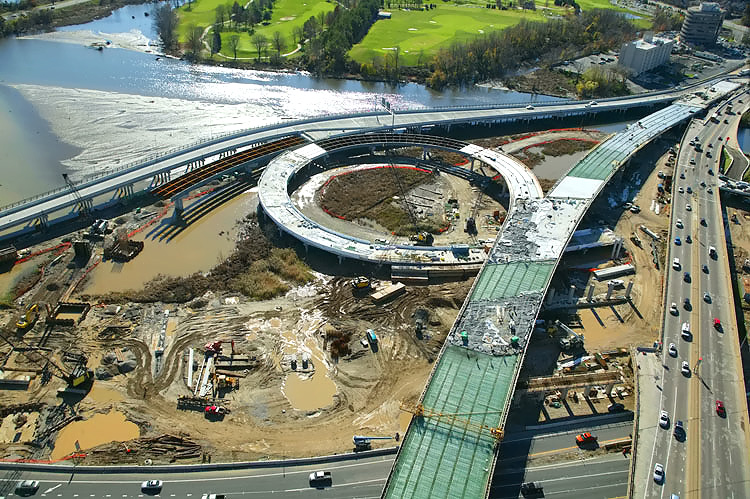
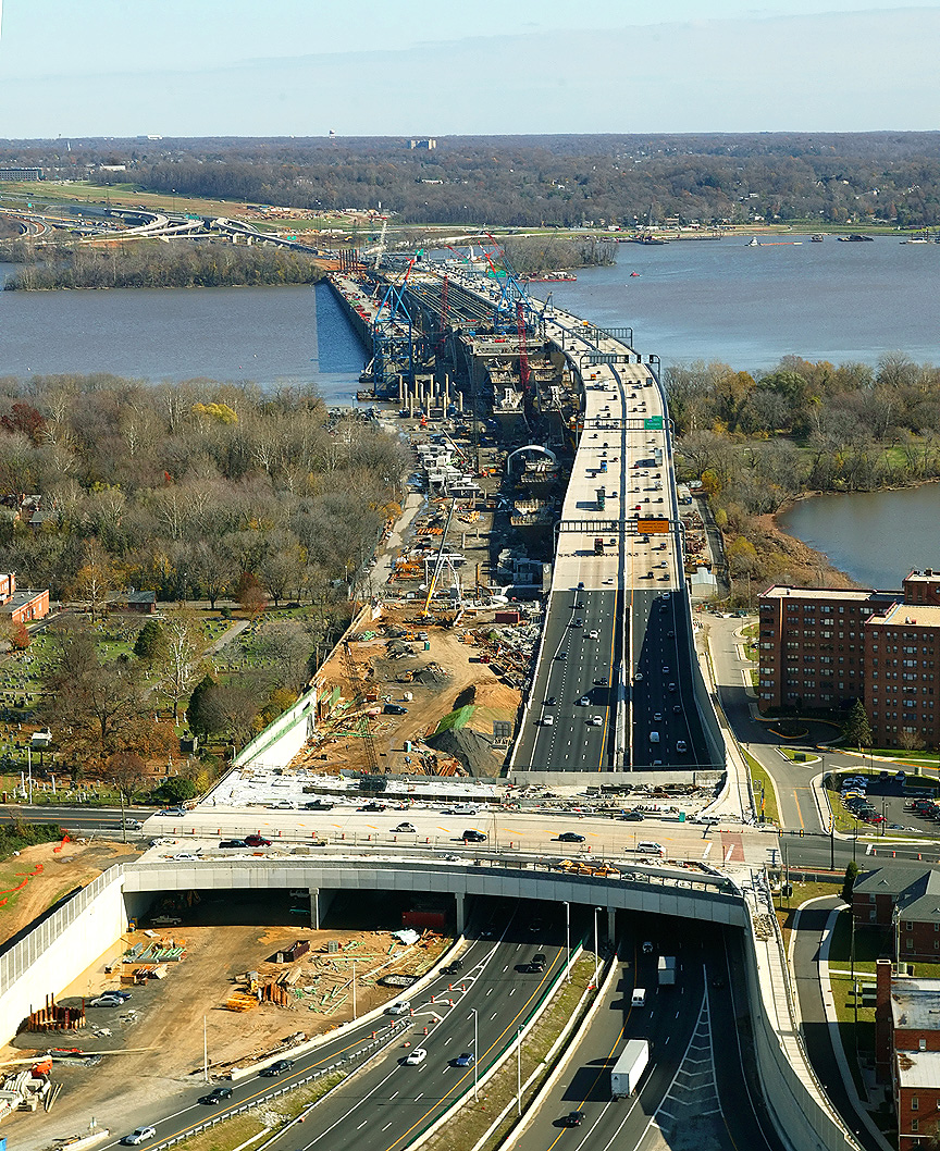
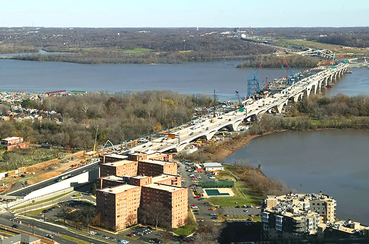
Looking eastward along the Beltway, from above the US-1 interchange in Virginia; and visible in the distance are the Woodrow Wilson Bridge, Potomac River and Maryland. The Hunting Towers Apartments are to the right. The Washington Street Urban Deck has been completed over the future local and express Beltway Outer Loop roadways, with Beltway traffic operating there; and it is under construction over the future local and express Beltway Inner Loop roadways. |
 |
This
is a large version of the previous photo, with a size of 810 kilobytes. LARGE PHOTO |
 |
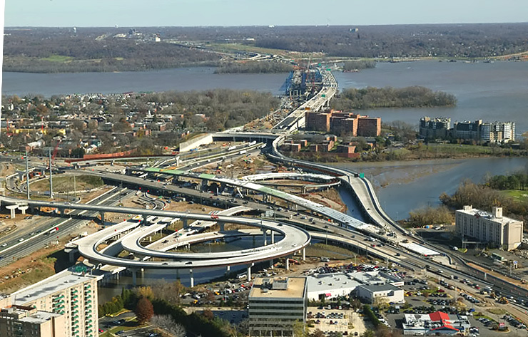
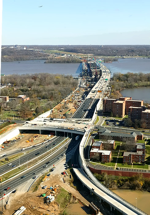
Looking eastward along the Beltway, from above the US-1 interchange in Virginia; and visible in the distance are the Woodrow Wilson Bridge, Potomac River and Maryland. The Hunting Towers Apartments are to the right. |
 |
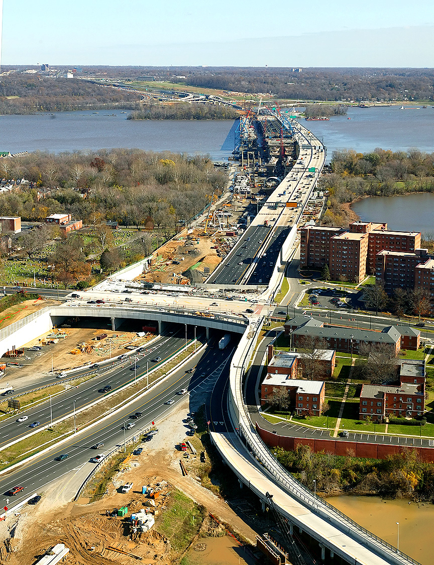
Looking eastward along the Beltway from Virginia, and visible in the distance are the Woodrow Wilson Bridge, Potomac River and Maryland. The Hunting Towers Apartments are in the lower part of the photo. |
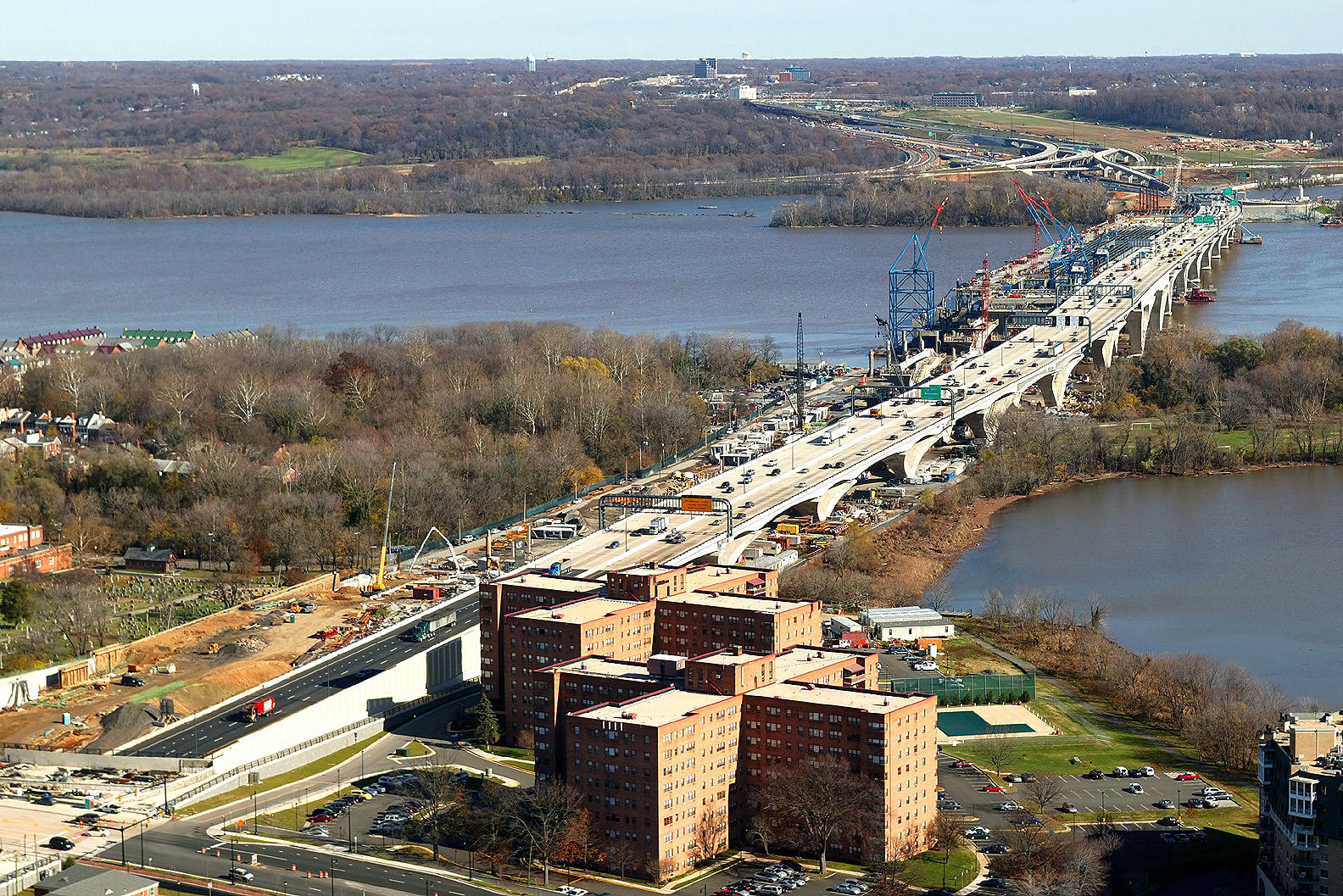 |
This
is a large version of the previous photo, with a size of 1,003 kilobytes. LARGE PHOTO |
Lead article - Woodrow Wilson Bridge Project Photos
This article was released on January 6, 2007, with the first 30 photos. The last 28 photos were added on February 1, 2007. Large zoom-in excerpt photos were added on April 4, 2007, for photos 41, 43, 44, 46, 55, 56 and 58, and these photos are marked "LARGE PHOTO" in large bold letters next to the photo.
Copyright © 2007 by Scott Kozel. All rights reserved. Reproduction, reuse, or distribution without permission is prohibited.
By Scott M. Kozel, Capital Beltway dot com, Roads to the Future
(Created 1-6-2007, moved to capital-beltway.com on 3-24-2007, last updated 4-4-2007 )