
| Woodrow Wilson Bridge Project Photos - June 2007 |
The following 52 photos show various aerial views of the I-95/I-495 Woodrow Wilson Bridge (WWB) Project construction, including the new Potomac River Bridge construction, the Virginia U.S. Route 1 Interchange construction, and the Washington Street Urban Deck construction, and the Maryland Interstate 295 Interchange construction. There are interesting views of Old Town Alexandria, Virginia.
These photos were taken on June 4, 2007 by the Virginia Department of Transportation, and are posted here with their permission. Roads to the Future utilized PhotoDeluxe Business Edition to sharpen and brighten and to align all of the photos. Click on the photo to get a large version of the photo. In later versions of Netscape and Internet Explorer, you probably will need to use Full Screen mode (the F11 key can be utilized to swap back and forth between Full Screen and Regular) to see the full size of the large photo without browser-induced image shrinkage. The large photos have sizes ranging from 119 to 484 kilobytes, with most of them being under 286 kilobytes. With a broadband or network Internet connection each photo will download within seconds, but with a dial-up Internet connection it will be somewhat slower.
Click to go to LATEST INFORMATION UPDATE.
 |
The I-95/I-495
Capital Beltway and VA-241 Telegraph Road Interchange, looking north along
Telegraph Road. Telegraph Road is a 4- to 6-lane arterial, and the Beltway
interchange is in the center of the photo. The 8-lane I-95/I-495 Capital Beltway runs left to right, Hunting Creek (also known as Cameron Run) is just below the Beltway. The VA-241 Telegraph Road Interchange of the Beltway was originally built in 1961 as a modified cloverleaf interchange with one semi-directional ramp. The road paralleling just above the Beltway is the 4-lane Eisenhower Avenue, and it has a long bridge over Telegraph Road. Telegraph Road runs bottom to top, and its junctions from bottom to top in order are, the interchange with the Beltway, an interchange with local roads in the Eisenhower Valley, and the northern terminus of Telegraph Road which has a trumpet interchange with VA-236 Duke Street in Alexandria. The mainline of the CSXT Railroad and the Norfolk Southern Railroad parallels between Eisenhower Avenue and VA-236 Duke Street. Telegraph Road mainline bridges in this photo are, over Hunting Creek, over the mainline railroads, and over Duke Street. |
 |
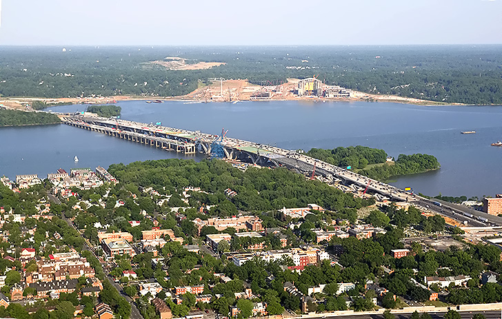
The I-95/I-495 Capital Beltway runs lower left to top, Hunting Creek is just to the right of the Beltway, the Potomac River is in the upper part of the photo, the U.S. Route 1 Interchange construction is in the canter of the photo, and the Woodrow Wilson Bridge is in the upper center of the photo. Virginia is on this side of the Potomac River, and Maryland is on the opposite side. |
 |
The I-95/I-495 Capital Beltway runs lower left to top, Hunting Creek is just to the right of the Beltway, the Potomac River is in the upper part of the photo, the U.S. Route 1 Interchange construction is in the canter of the photo, and the Woodrow Wilson Bridge is in the upper center of the photo. Virginia is on this side of the Potomac River, and Maryland is on the opposite side. |
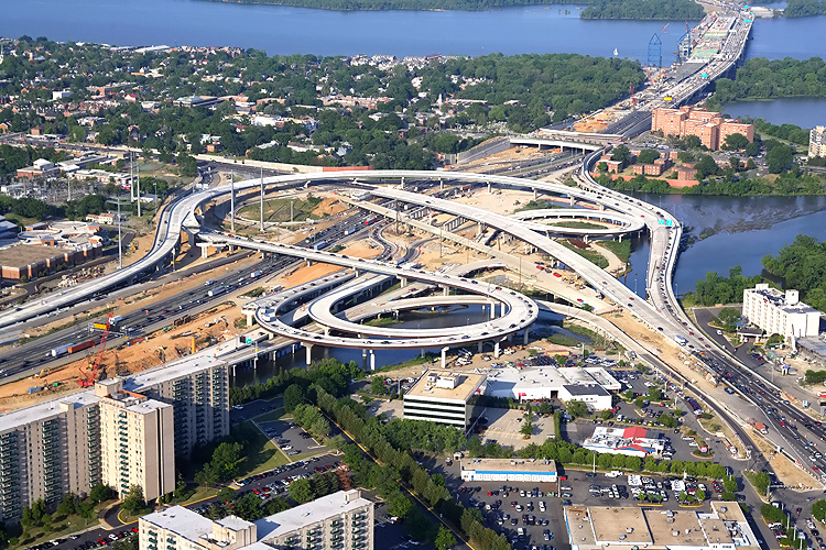 |
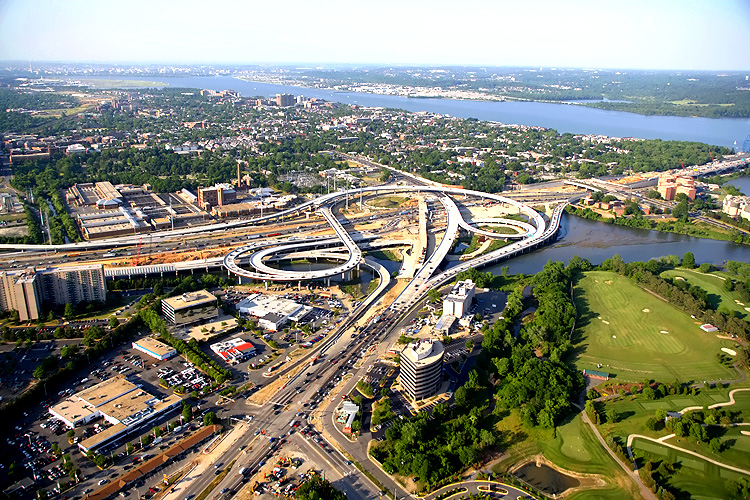
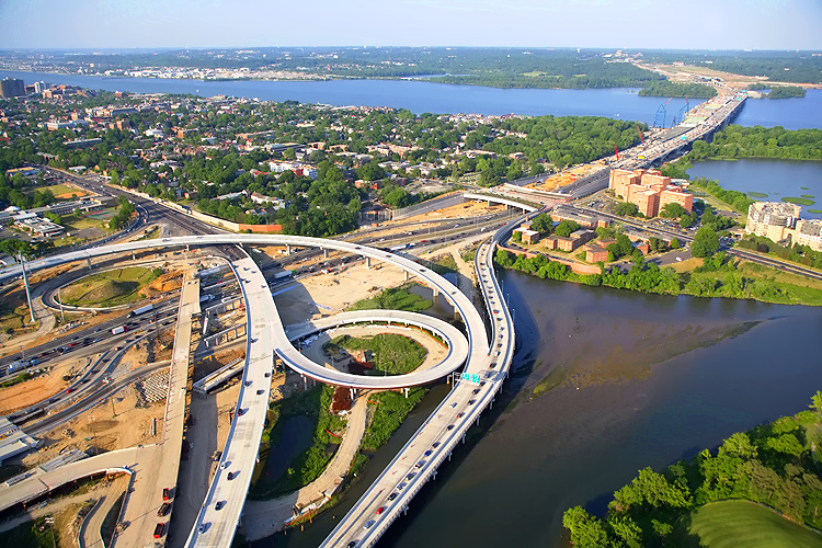
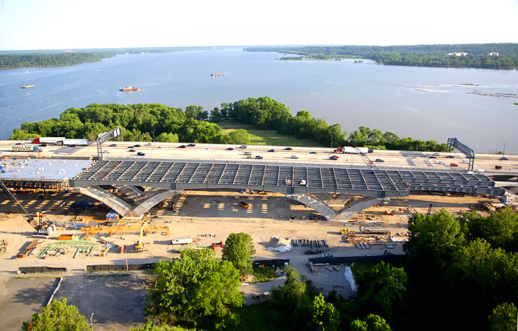
The I-95/I-495
Capital Beltway runs lower left to upper right, Hunting Creek is just to the
right of the Beltway, the Potomac River is in the upper part of the photo,
the U.S. Route 1 Interchange construction is in the canter of the photo, and
the Woodrow Wilson Bridge is in the upper right of the photo. Virginia is
on this side of the Potomac River, and Maryland is on the opposite side.
The downward curving elevated ramp at the middle of the photo is the newly opened flyover ramp from northbound US-1 to the Beltway Inner Loop (toward Springfield), and this ramp opened to traffic on May 6, 2007. |
 |
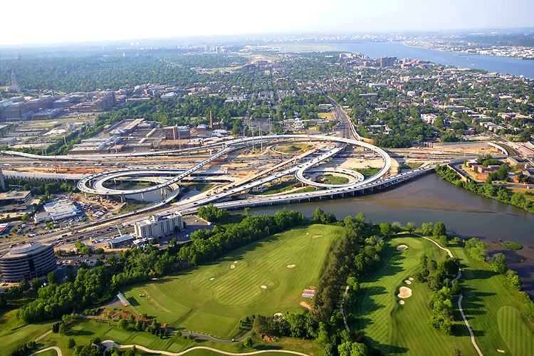
The I-95/I-495 Capital Beltway runs middle left to upper right, Hunting Creek is just to the right of the Beltway, the Potomac River is in the upper part of the photo, the U.S. Route 1 Interchange construction is in the center of the photo, and the Woodrow Wilson Bridge is in the upper right of the photo. Virginia is on this side of the Potomac River, and Maryland is on the opposite side. The highway in the lower right is US-1 in Fairfax County. |
 |
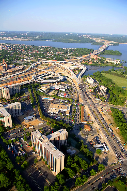
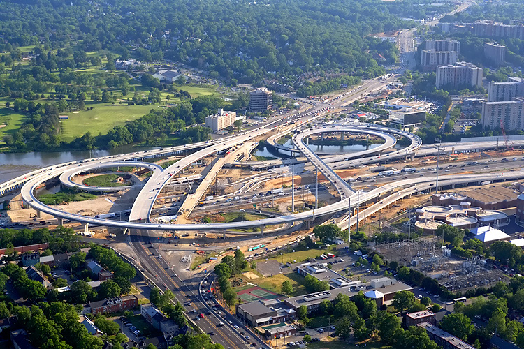
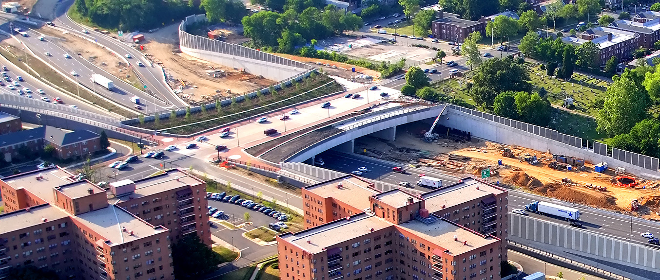
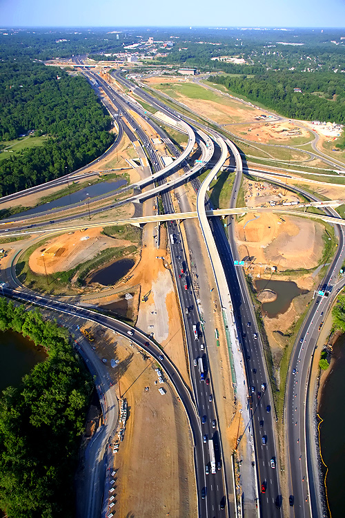
Looking eastward along the Beltway from the Virginia U.S. Route 1 Interchange, and visible in the distance are the Woodrow Wilson Bridge, Potomac River and Maryland. The Hunting Towers Apartments are in the middle part of the photo. |
 |
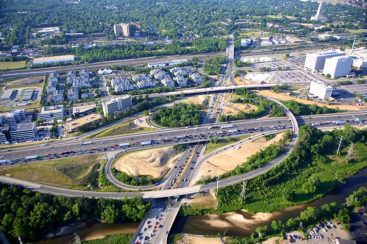
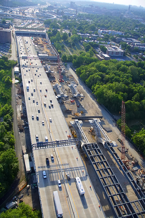
U.S. Route
1 Interchange construction, looking north across Hunting Creek and the I-95/I-495
Capital Beltway, with Alexandria on the north side of the Beltway. US-1 runs
from bottom to top, the Beltway runs from left to right.
Notice the new 3-lane northbound US-1 bridge, which passes over Hunting Creek, low-lying land, and the Beltway. It is temporarily carrying 2 lanes each way. The new US-1 bridge opened to traffic on March 4, 2007. The pre-existing US-1 bridge is being demolished so that the new 3-lane southbound US-1 bridge can be constructed, and the second bridge is under construction. |
 |
U.S. Route 1 Interchange construction, looking north across Hunting Creek and the I-95/I-495 Capital Beltway, with Alexandria on the north side of the Beltway. |
 |
U.S. Route 1 Interchange construction, looking north across Hunting Creek and the I-95/I-495 Capital Beltway, with Alexandria on the north side of the Beltway. |
 |
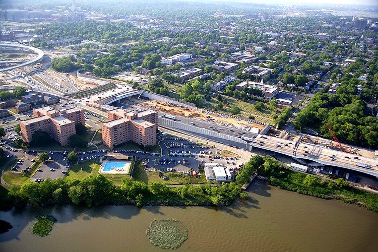
Mount Vernon Memorial Highway runs from the bottom of the photo, upward past the apartment complex where the Mount Vernon Memorial Highway becomes Washington Street, and Washington Street crosses the Beltway and goes into Old Town Alexandria. The Beltway runs left-right across the center of the photo. The Washington Street Urban Deck is under construction in the center of the photo. Old Town Alexandria is in the upper part of the photo, and National Airport, and downtown Washington, D.C., is in the far distance. |
 |
U.S. Route 1 Interchange construction, looking west across Hunting Creek and the I-95/I-495 Capital Beltway, with Alexandria on the north side of the Beltway. The Beltway heads west into the distance in the upper left of the photo. |
 |
Looking west along the Beltway, showing construction of the U.S. Route 1 Interchange. The upward curving elevated ramp at the bottom of the photo is the newly opened flyover ramp from northbound US-1 to the Beltway Inner Loop (toward Springfield), and this ramp opened to traffic on May 6, 2007. |
 |
Looking south along US-1, showing construction of the U.S. Route 1 Interchange. The upward curving elevated ramp at the bottom of the photo is the newly opened flyover ramp from northbound US-1 to the Beltway Inner Loop (toward Springfield). |
 |
Looking south along US-1, showing construction of the U.S. Route 1 Interchange. |
 |
Looking south along US-1, showing construction of the U.S. Route 1 Interchange. |
 |
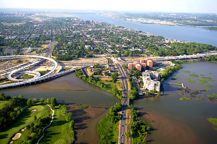
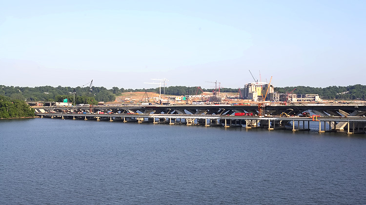
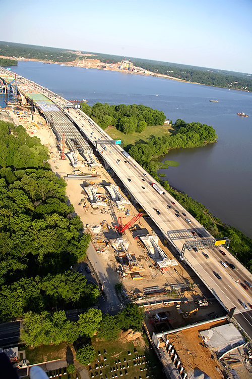
The I-95/I-495 Capital Beltway runs lower right to upper left, the Potomac River is in the upper part of the photo, the U.S. Route 1 Interchange construction is in the center of the photo. Virginia is on this side of the Potomac River, and Maryland is on the opposite side. |
 |
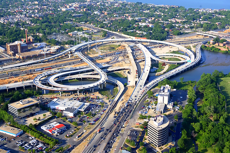
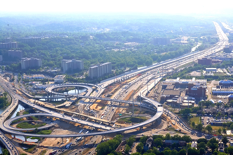
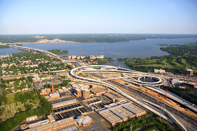
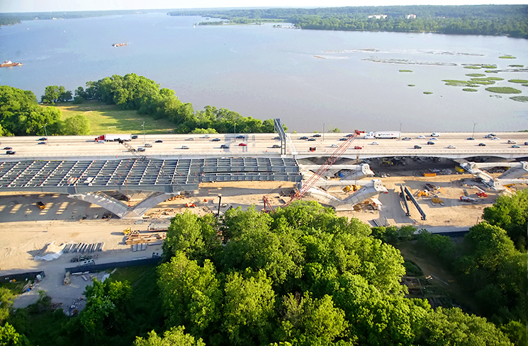
The I-95/I-495 Capital Beltway runs bottom to top, Hunting Creek (also known as Cameron Run) is just to the right of the Beltway, the Potomac River is in the upper part of the photo, the U.S. Route 1 Interchange construction is in the upper part of the photo. Notice the elevated ramps under construction in the center left of the photo, they are part of the local ramps that will connect the Eisenhower Valley in Alexandria, Virginia, to the Beltway's traffic to and from Maryland. |
 |
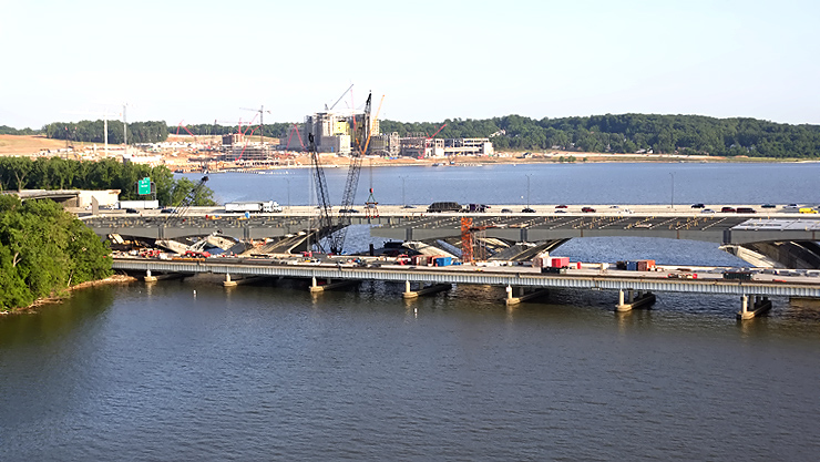
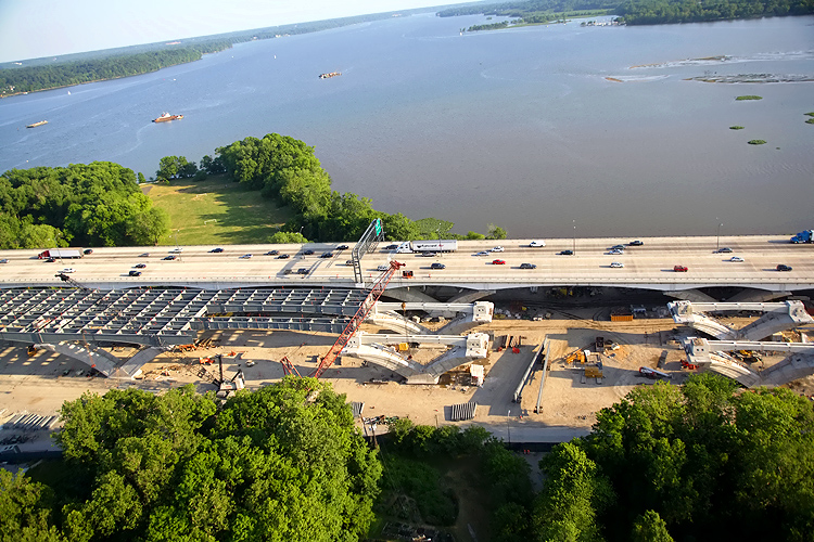
The I-95/I-495 Capital Beltway runs bottom to top, Hunting Creek is just to the right of the Beltway, the Potomac River is in the upper part of the photo, the U.S. Route 1 Interchange construction is in the upper part of the photo, and the Woodrow Wilson Bridge is in the upper part of the photo. The long new bridge on the right side of the Beltway, is part of the completed US Route 1 Interchange Advanced Bridge contract, and the bridge will carry the Beltway Outer Loop local roadway; currently it is carrying local traffic exiting the Beltway to US-1. |
 |
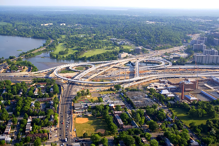
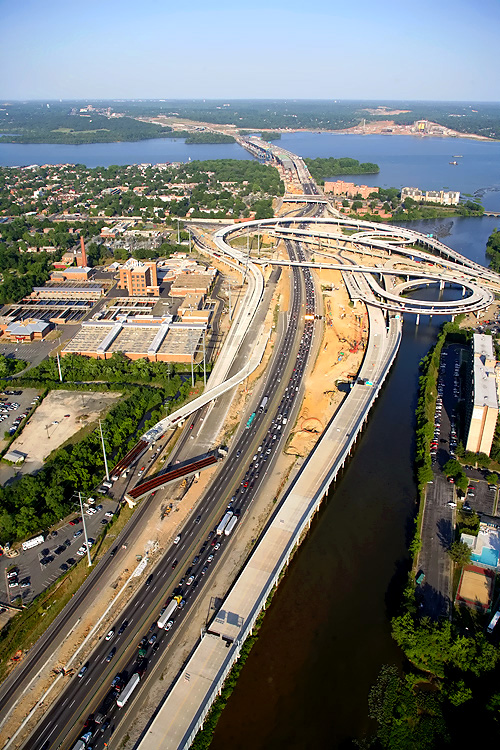
U.S. Route 1 Interchange construction, looking east along the I-95/I-495 Capital Beltway, with Alexandria on the north side of the Beltway, and the Potomac River, the Woodrow Wilson Bridge, and Maryland, visible in the distance. |
 |
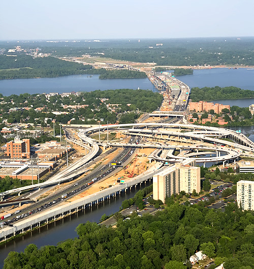
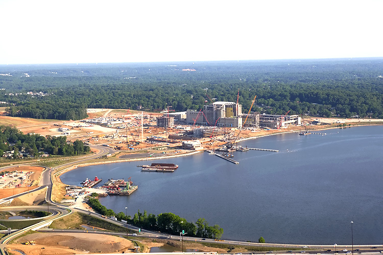
Woodrow
Wilson Bridge and Potomac River in the center of the photo, Old Town Alexandria
is in the lower part of the photo. The construction on the Maryland side of
the river is National Harbor.
Website for National Harbor. |
 |
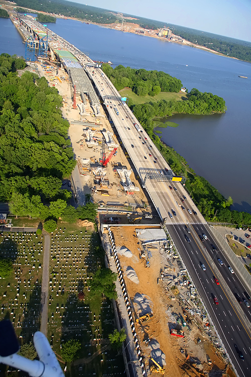
The I-95/I-495 Capital Beltway runs left to right, the Potomac River is in the lower part of the photo, the U.S. Route 1 Interchange construction is mostly off the left edge of the photo, and the Woodrow Wilson Bridge begins in the right of the photo. Old Town Alexandria, Virginia is in the upper part of the photo. The Washington Street Urban Deck is under construction in the left of the photo. |
 |
Zoom-in excerpt of the previous photo, showing the Washington Street Urban Deck under construction. The reinforced concrete structure of the deck is complete, and about 6 feet depth of earthen fill is being placed on the portions of the deck where grass and trees are being planted. Photo size is 484 kilobytes. |
 |
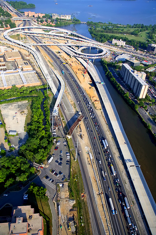
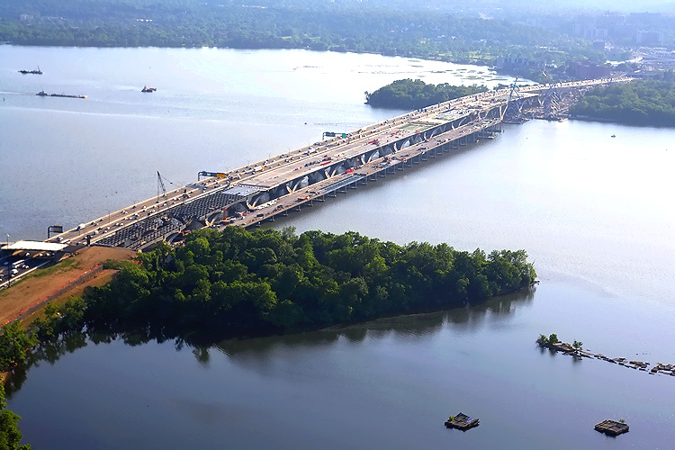
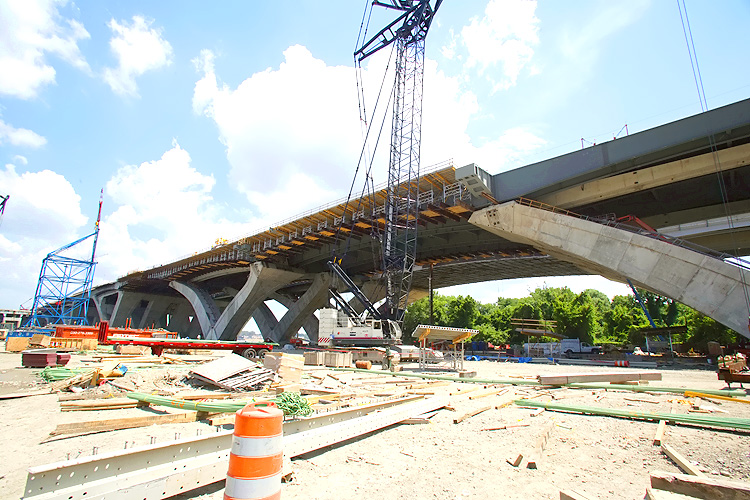
Virginia approaches construction to the Potomac River Bridge, looking north. Construction in the foreground is the Potomac River Bridge Virginia Approach Spans contract, and the new 6-lane Outer Loop WWB is visible, and it is carrying 3 lanes each way until the second new 6-lane Inner Loop WWB, which is under construction above the new bridge, opens to traffic in mid-2008. The new Virginia abutment for the Potomac River Bridge is visible in the left of the photo. |
 |
Virginia approaches construction to the Potomac River Bridge, looking west. Construction in the foreground is the Potomac River Bridge Virginia Approach Spans contract, and the new 6-lane Outer Loop WWB is visible to the left, and it is carrying 3 lanes each way until the second new 6-lane Inner Loop WWB, which is under construction to the right, opens to traffic in mid-2008. The new Virginia abutment for the Potomac River Bridge is visible in the center of the photo, and the land approach construction is visible above that, and the Washington Street Deck construction is visible, with the U.S. Route 1 Interchange construction visible in the distance. |
 |
Virginia approaches construction to the Potomac River Bridge, looking west. Construction in the foreground is the Potomac River Bridge Virginia Approach Spans contract, and the new 6-lane Outer Loop WWB is visible to the left, and it is carrying 3 lanes each way until the second new 6-lane Inner Loop WWB, which is under construction to the right, opens to traffic in mid-2008. |
 |
Old Town Alexandria, Virginia, looking north from above the Woodrow Wilson Bridge. More details in the following photos. |
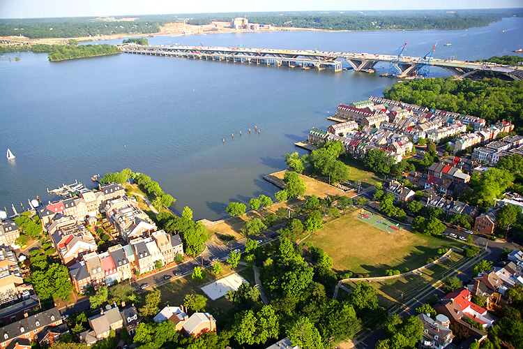 Photo #27 |
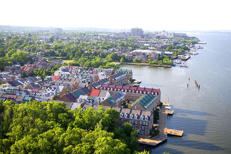
I have mentioned in the past having lived in Old Town Alexandria, Virginia, near the I-495 Woodrow Wilson Bridge, as in less than a mile from the bridge, and being able to see the Potomac River and the eastern half of the bridge and the Beltway upgrade into Maryland from a small urban park that is a block away from where we lived. We lived on the 400 block of South Lee Street from 1969 to 1971, and then my parents moved to the 400 block of Queen Street which is about 8 blocks west and a couple blocks from the old city hall buildings in the center of Old Town. I moved away to college in 1972, and my parents lived in the second location until 1986 when they retired and moved to the Eastern Shore of Maryland where they currently live. The following 5 aerial photos show the area around our South Lee Street residence, the river, the park, and the Woodrow Wilson Bridge. This photo is looking from above Old Town, across the river, the WWB construction, with Maryland in the distance, and notice the National Harbor buildings under construction in Maryland. The urban park is named Pommander Park and is about one city block in size and is in the lower right of the photo. The street immediately paralleling the river is South Union Street, and all the visible townhouses between that street and the river are new construction built between 1970 and the current, and mostly since about 1990. The townhouses visible inland from South Union Street are all historic homes dating from before 1900 and many from before 1850. |
 |
This photo is a slightly different perspective looking across Pommander Park in the lower part of the photo, across the river, with the eastern part of the old and new WWB in the right of the photo, and the Beltway/I-295 interchange construction in Maryland visible in the upper center of the photo. I recognize the townhouses in the very lower left corner of the photo as being directly across the street from our South Lee Street residence. The street paralleling the bottom of the photo is South Lee Street. |
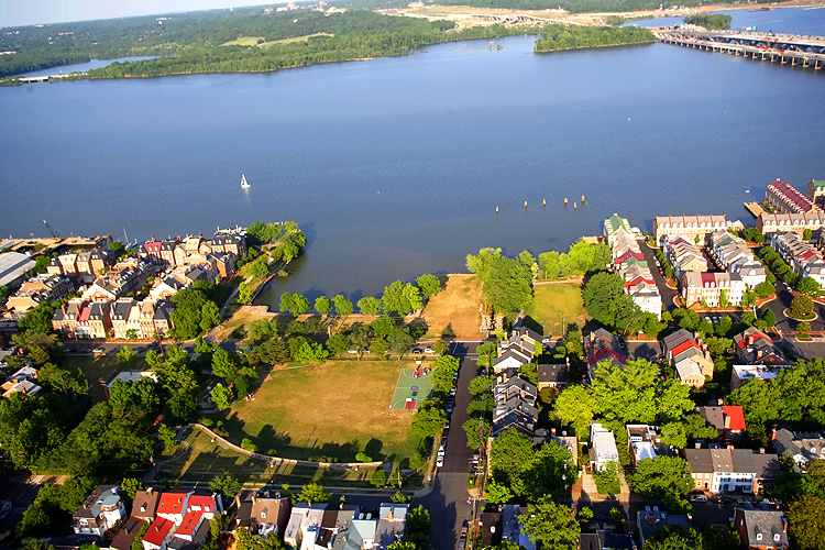 |
This photo is a slightly different perspective looking across Pommander Park in the lower part of the photo, across the river, with the eastern part of the old and new WWB in the right of the photo, and the Beltway/I-295 interchange construction in Maryland visible in the upper center of the photo. |
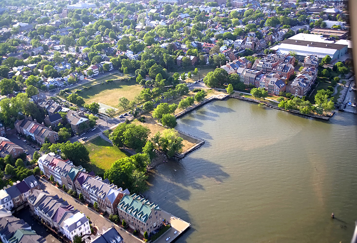 |
This photo is almost the reverse perspective from the first photo (#27), looking from over the river toward Pommander Park with the historic part of Old Town inland of Union Street. Those new townhouses along the river didn't exist when we lived there. They were built on land that was reclaimed from abandoned docks and port facilities. They are generally much larger homes and much more expensive, than the historic Old Town homes, although the new townhouses are architecturally nicely designed in a very similar way to the historic townhouses. The last photo also shows how the inland (Lee Street) side of Pommander Park is on a bluff behind a masonry retaining wall. It is a good 30 feet above the elevation of the river. I could walk one block from our house and have an excellent view of the river, and the Woodrow Wilson Bridge. At night there was the interesting view of a sag curve of the overhead lighting on the Beltway, as what is visible of the Beltway from the park is from the top of the hill in Maryland to the high point of the Woodrow Wilson Bridge. I can testify that in many places in Old Town, the Woodrow Wilson Bridge is not visible at all from street level. It was not visible at all from our house, although you could hear a faint drone of traffic on the bridge which was (and is) part of the I-495 Capital Beltway. |
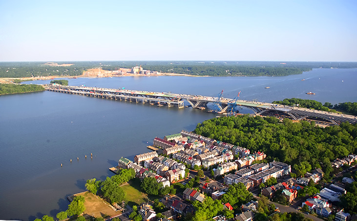 |
Above Old Town, looking south toward the old and new WWB in the center of the photo, and Maryland visible in the upper center of the photo. |
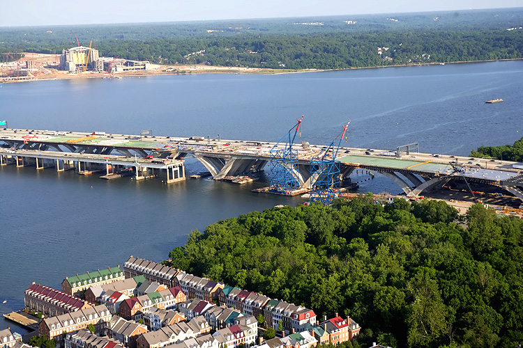 |
Similar perspective to previous photo, closer view of the center section of the WWB. The bascule span and shipping channel is about 500 feet from the Virginia shoreline. |
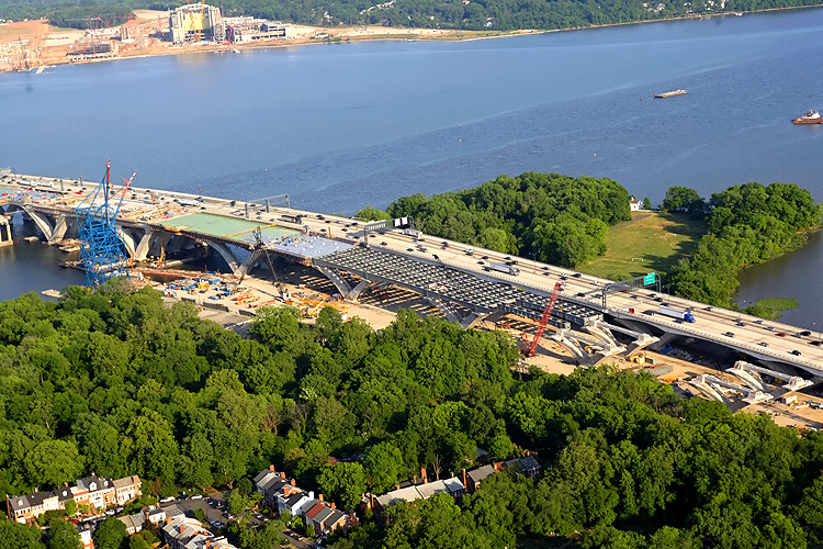 |
Similar perspective to previous photo, closer view of the center section of the WWB and the Virginia approach section of the bridge. |
 |
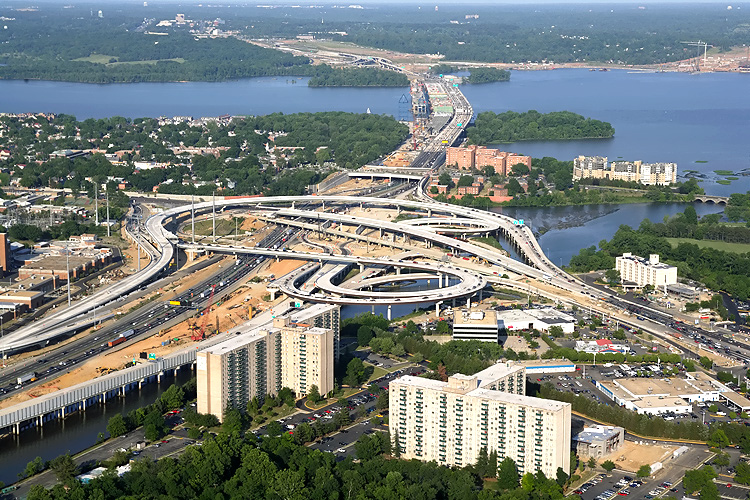
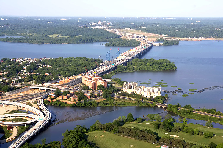
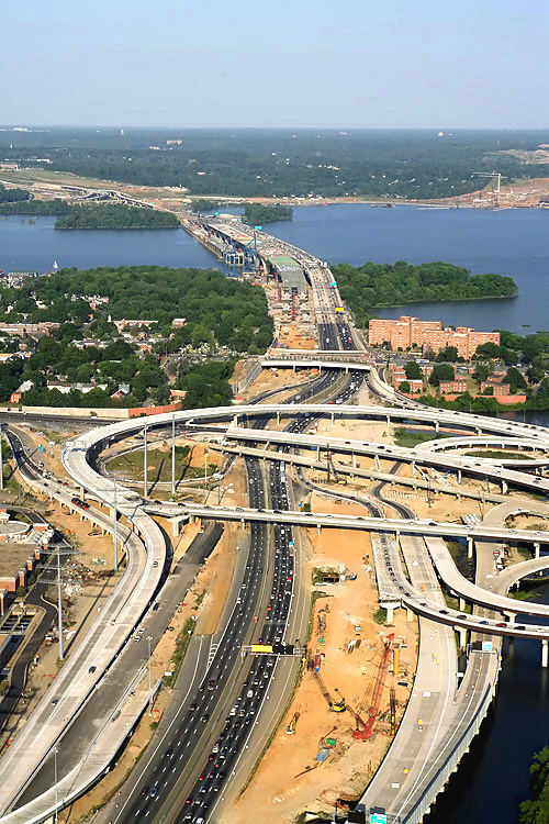
Looking eastward along the Beltway, from above the US-1 interchange in Virginia; and visible are the Woodrow Wilson Bridge, Potomac River and Maryland. The Maryland approach of the original WWB is to the left and the new 6-lane WWB is to the right, and the under construction second new 6-lane WWB is in the middle. |
 |
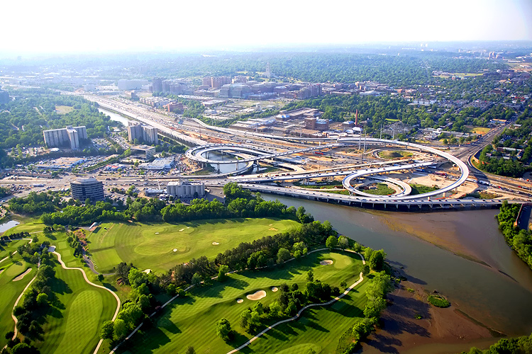
The I-95/I-495 Capital Beltway runs lower left to upper right, Hunting Creek is just below the Beltway, the Potomac River is in the upper part of the photo, the U.S. Route 1 Interchange construction is in the canter of the photo, and the Woodrow Wilson Bridge is in the upper right of the photo. Virginia is on this side of the Potomac River, and Maryland is on the opposite side. |
 |
Woodrow Wilson Bridge construction, looking west, with the old closed WWB to the right, the new 6-lane WWB to the left, and the under construction second new 6-lane WWB in the center. Virginia is on the opposite side of the Potomac River, and Maryland is on the near side of the river. |
 |
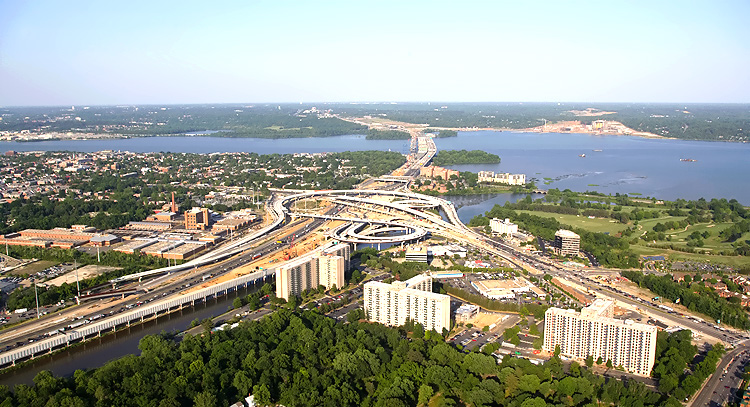
Interstate 295 Interchange construction, looking east along the I-95/I-495 Beltway, the Potomac River Bridge is just off of the bottom edge of the photo. In the lower half of the photo is land Beltway roadway construction, between Rosalie Island and the Maryland mainland. |
 |
The I-95/I-495 Capital Beltway runs left to
right across the bottom edge of the photo, the land roadway between
Rosalie Island and the Maryland mainland. The building construction in the
center of the photo is National Harbor.
Website for National Harbor. |
 |
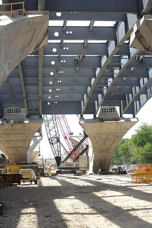
Potomac River Bridge construction, looking south, view of the Potomac River Bridge Maryland Approach Spans contract construction. |
 |
Potomac River Bridge construction, looking south, view of the Maryland Approach Spans construction. The old closed 6-lane Woodrow Wilson Bridge is visible on the near side of the new bridge construction. Notice the Beltway traffic on the opposite-side new bridge. |
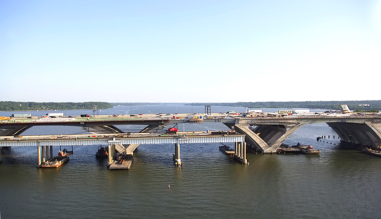 |
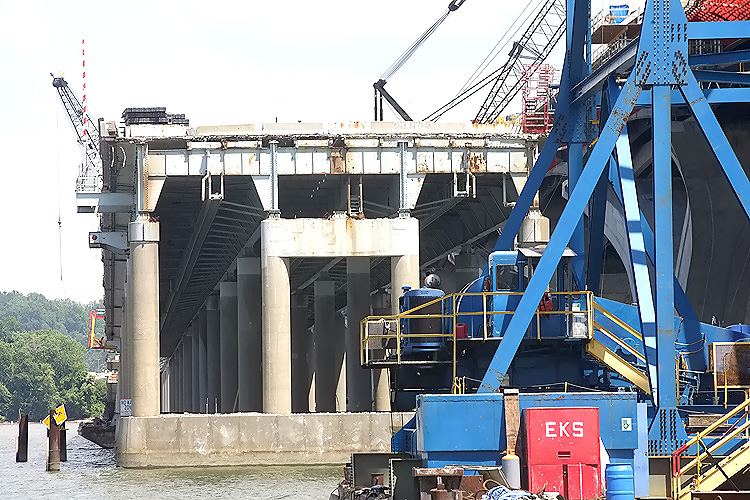
Potomac River Bridge construction, looking south, view of the Maryland Approach Spans construction. The Maryland approach of the old closed 6-lane Woodrow Wilson Bridge is visible on the near side of the new bridge construction, and the old WWB bascule span has been removed. The Bascule Span construction of the new WWB, which is being built under the Potomac River Bridge Bascule Spans contract, is visible in the right of the photo. |
 |
Potomac River Bridge construction, looking
south, view of the Maryland Approach Spans construction and Bascule Spans
construction. The Maryland approach of the old closed 6-lane Woodrow
Wilson Bridge is visible on the near side of the new bridge construction,
and the old WWB bascule span has been removed.
The Maryland approach of the old closed 6-lane WWB is currently being used a construction access road to bring concrete and materials to the construction site of the Maryland approach of the new Inner Loop WWB. |
 |
Potomac River Bridge construction, looking south, view of the Maryland Approach Spans construction and Bascule Spans construction. The Maryland approach of the old closed 6-lane Woodrow Wilson Bridge is visible on the near side of the new bridge construction, and the old WWB bascule span has been removed. |
 |
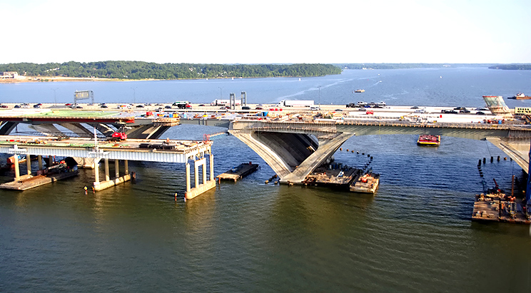
Construction in the center of the photo is the Potomac River Bridge Virginia Approach Spans contract. Jones Point is visible in the upper center of the photo. The Potomac River heads to the south in the distance. |
 |
Construction of the WWB Virginia Approach . The first new 6-lane bridge is open, and the second new bridge is under construction on the near side, notice the superstructure under construction on the Virginia overland approach. |
 |
Construction of the WWB Virginia Approach. The first new 6-lane bridge is open, and the second new bridge is under construction on the near side, notice the superstructure under construction on the Virginia overland approach, where steel girders have been placed, with the construction of the reinforced concrete roadway deck to follow. |
 |
Construction of the WWB Virginia Approach. Jones Point is visible in the upper center of the photo. The Potomac River heads to the south in the distance. |
 |
Construction of the WWB Virginia Approach. Jones Point is visible in the upper center of the photo. The Potomac River heads to the south in the distance. The first new 6-lane bridge is open, and the second new bridge is under construction on the near side, notice the V-piers under construction on the Virginia overland approach. |
 |
Construction of the WWB Virginia Approach. Jones Point is visible in the upper left of the photo. The Potomac River heads to the south in the distance. The first new 6-lane bridge is open, and the second new bridge is under construction on the near side, notice the V-piers under construction on the Virginia overland approach. |
 |
Potomac River Bridge construction, looking east from Virginia into Maryland. The new 6-lane Outer Loop bridge is to the right. The under construction 6-lane Inner Loop bridge is to the left. The Virginia abutment (terminal structure) of the new bridge is in the lower right of the photo. |
 |
Potomac River Bridge construction, looking east from Virginia into Maryland. The new 6-lane Outer Loop bridge is to the right. The under construction 6-lane Inner Loop bridge is to the left. The Virginia abutment (terminal structure) of the new bridge is in the lower center of the photo. |
**LATEST INFORMATION UPDATE follows**
The following 26 photos show various views of the I-95/I-495 Woodrow Wilson Bridge (WWB) Project construction, including the new Potomac River Bridge construction. These photos were taken on June 11, 2007 by the Virginia Department of Transportation. Roads to the Future utilized PhotoDeluxe Business Edition to sharpen and brighten and to align all of the photos. Click on the photo to get a large version of the photo. In later versions of Netscape and Internet Explorer, you probably will need to use Full Screen mode (the F11 key can be utilized to swap back and forth between Full Screen and Regular) to see the full size of the large photo without browser-induced image shrinkage. The large photos have sizes ranging from 148 to 290 kilobytes, with most of them being under 196 kilobytes. With a broadband or network Internet connection each photo will download within seconds, but with a dial-up Internet connection it will be somewhat slower.
 |
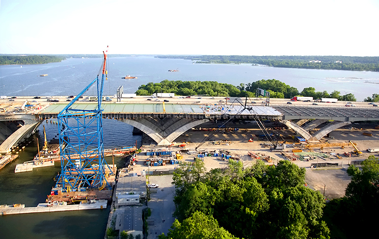
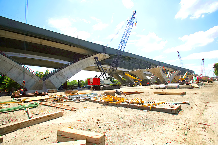
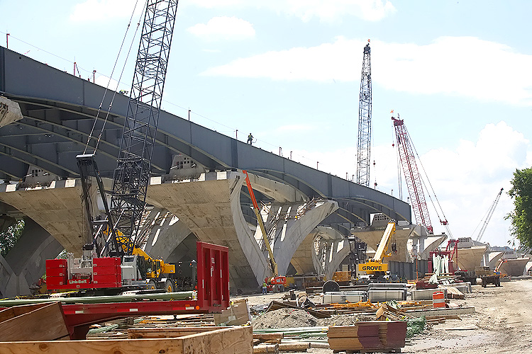
Potomac River Bridge construction of the 6-lane Inner Loop bridge, looking east toward the river, at the Virginia Approach Spans (Potomac River Bridge Virginia Approach Spans contract) construction, from the land under the bridge, showing the V-piers that have been constructed and the steel girders that have been placed. The completed 6-lane Outer Loop WWB is partially visible to the right. |
 |
Potomac River Bridge construction of the 6-lane Inner Loop bridge, looking east, at the Virginia Approach Spans construction, from the land under the bridge, showing the V-piers that have been constructed and the steel girders that have been placed. The completed 6-lane Outer Loop WWB is partially visible to the right. |
 |
Potomac River Bridge construction, looking north, at the Virginia Approach Spans construction. V-pier construction is underway. |
 |
Potomac
River Bridge construction of the 6-lane Inner Loop bridge, looking east, at the Virginia Approach Spans
construction.
|
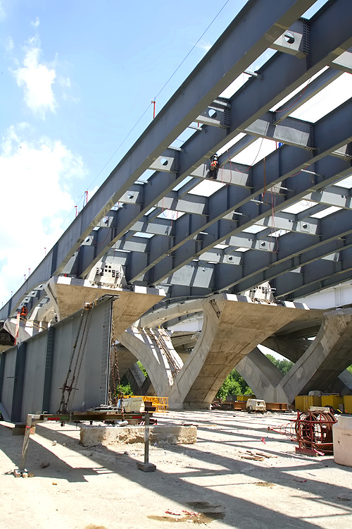 |
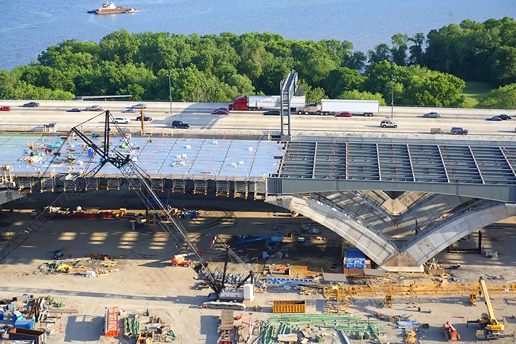
Potomac
River Bridge construction, looking east, at the Virginia Approach Spans construction,
from the land under the bridge, showing the
V-piers that have been constructed and the steel girders and stringers
that have been placed across the tops of the V-piers. The reinforced
concrete roadway deck will be constructed across the tops of the steel
girders.
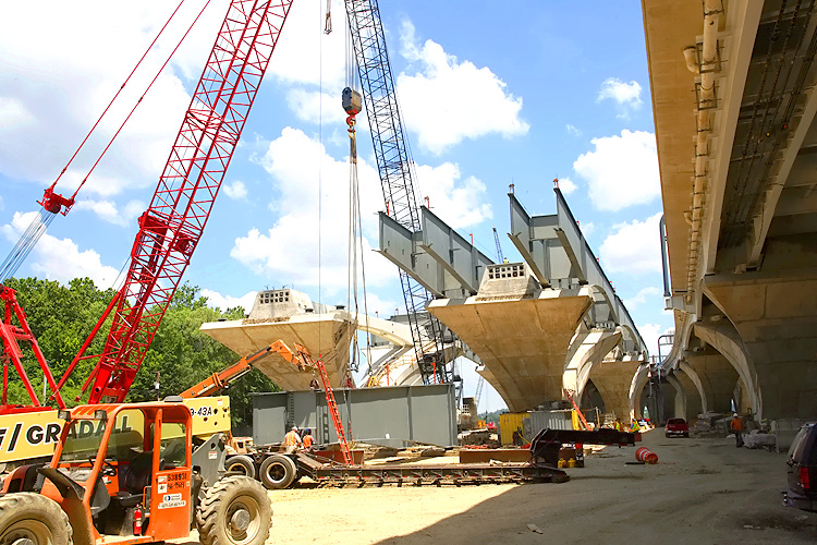
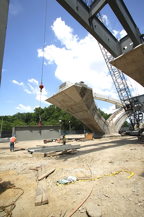
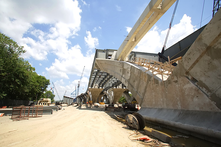
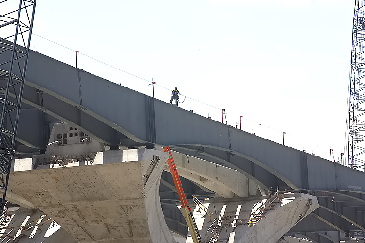
The V-piers on the approach spans are being constructed via the precast segmental method, whereby reinforced concrete segments are fabricated in a fabrication yard, and assembled on the pier foundation and post-tensioned with steel cables that pass through channels in the piers. The arches are held in place by temporary steel cables until the reinforced concrete cross-member links the two arches. |
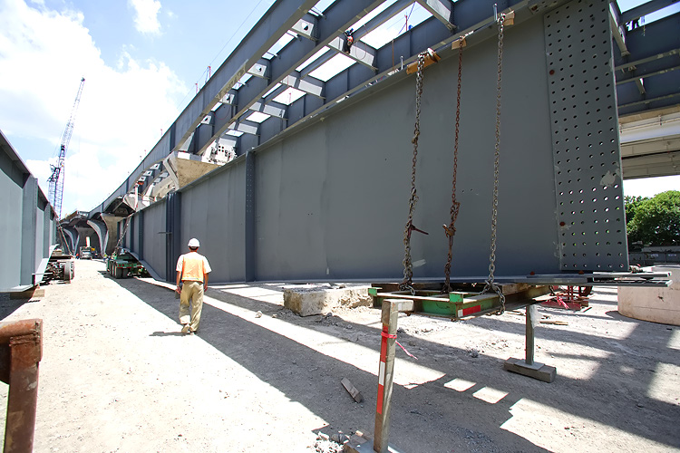 |
Potomac River Bridge construction, the Virginia Approach Spans construction of the 6-lane Inner Loop bridge. The large steel girder in the foreground is about to be lifted and placed on the piers. |
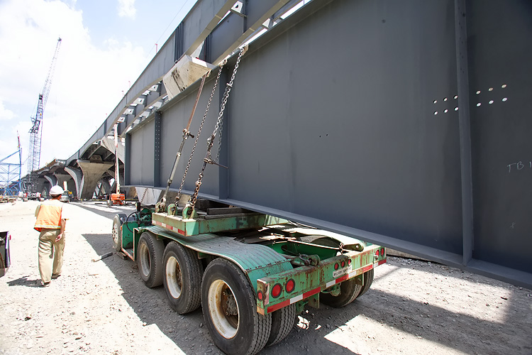 |
Potomac River Bridge construction, the Virginia Approach Spans construction of the 6-lane Inner Loop bridge. The large steel girder in the foreground is about to be lifted and placed on the piers. |
 |
Potomac River Bridge construction, the Virginia Approach Spans construction of the 6-lane Inner Loop bridge. |
 |
Potomac River Bridge construction, the Virginia Approach Spans construction of the 6-lane Inner Loop bridge. |
 |
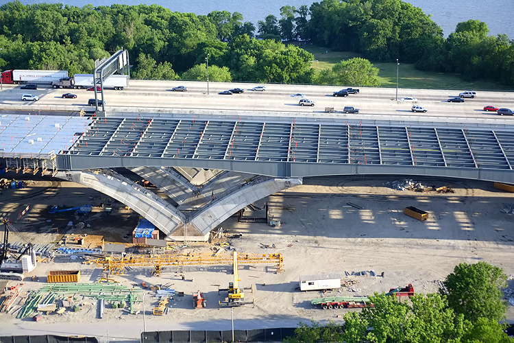
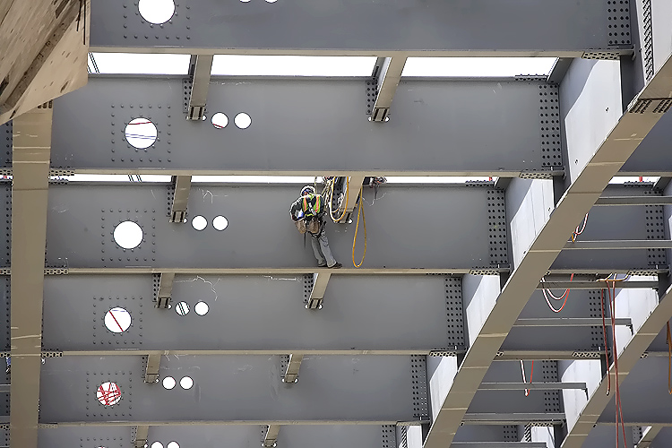
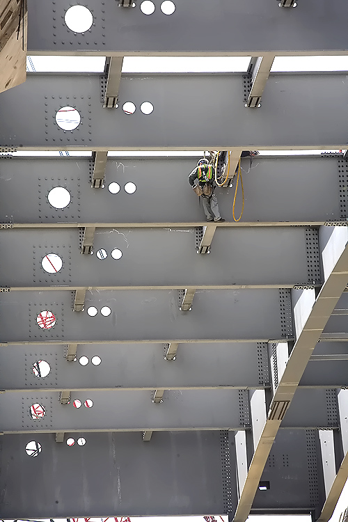
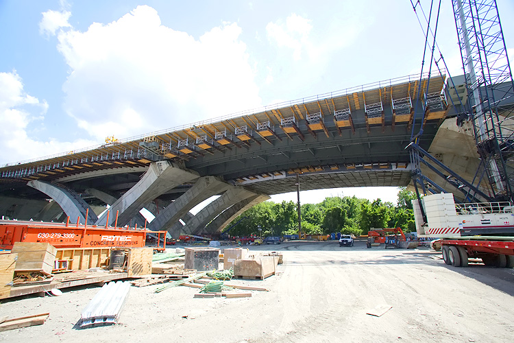
Potomac River Bridge construction, the Virginia Approach Spans construction of the 6-lane Inner Loop bridge, underside view of the steel girders and stringers that have been placed. |
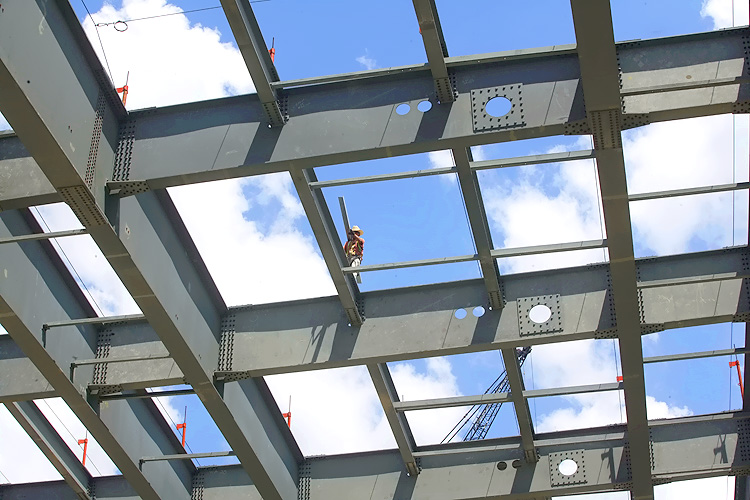 |
Potomac River Bridge construction, the Virginia Approach Spans construction of the 6-lane Inner Loop bridge, underside view of the steel girders and stringers that have been placed. The reinforced concrete roadway deck will be constructed across the tops of the steel girders. |
 |
Potomac River Bridge construction, the Virginia Approach Spans construction of the 6-lane Inner Loop bridge, underside view of the steel girders and stringers that have been placed. |
 |
Potomac River Bridge construction, the Virginia Approach Spans construction of the 6-lane Inner Loop bridge, underside view of the steel girders and stringers that have been placed. |
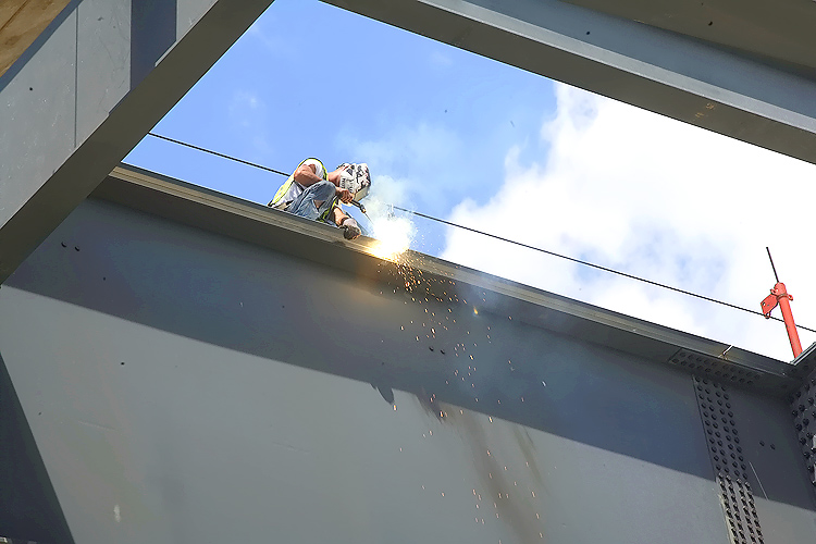 |
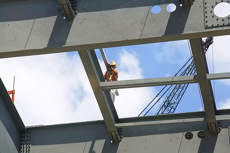
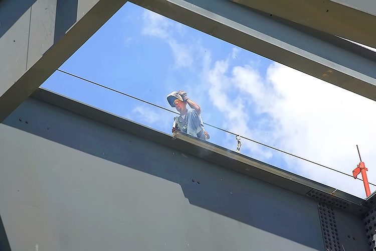
Potomac River Bridge construction, the Virginia Approach Spans construction of the 6-lane Inner Loop bridge, underside view of the steel girders and stringers that have been placed. Notice the welding worker. |
 |
Potomac River Bridge construction, the Virginia Approach Spans construction of the 6-lane Inner Loop bridge, underside view of the steel girders and stringers that have been placed. |
 |
Potomac River Bridge construction, the Virginia Approach Spans construction of the 6-lane Inner Loop bridge, underside view of the steel girders and stringers that have been placed. |
 |
Potomac River Bridge construction, the Virginia Approach Spans construction of the 6-lane Inner Loop bridge, underside view of the steel girders and stringers that have been placed. The shore of the Potomac River is near the cranes that are visible in the distance. |
 |
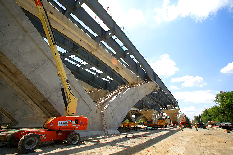
Potomac River Bridge construction, the Virginia Approach Spans construction of the 6-lane Inner Loop bridge, looking toward the river. The completed new 6-lane Outer Loop bridge is behind the bridge under construction. |
 |
Potomac River Bridge construction, the Virginia Approach Spans construction of the 6-lane Inner Loop bridge, looking toward the Virginia end of the bridge. |
 |
Potomac River Bridge construction, the Virginia Approach Spans construction of the 6-lane Inner Loop bridge. This span is adjacent to the river. |
 |
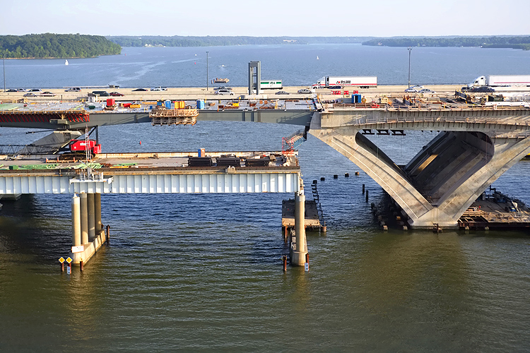
Potomac River Bridge construction is to the right. The Maryland approach of the original WWB is ahead, and the bascule span of the original WWB has been demolished and removed. |
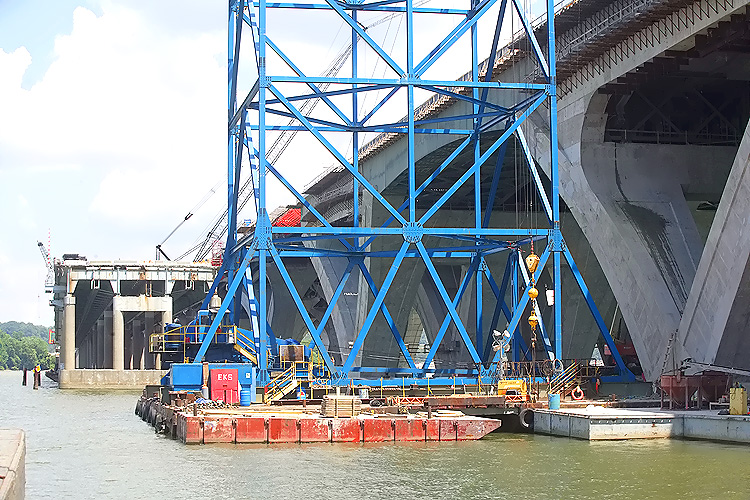 |
Potomac River Bridge construction is to the right. The Maryland approach of the original WWB is in the distance, and the bascule span of the original WWB has been demolished and removed. The new bridge's bascule span is in the center of the photo, and it is being built under the Potomac River Bridge Bascule Spans contract. |
 |
Potomac River Bridge construction, the Virginia Approach Spans construction of the 6-lane Inner Loop bridge. |
 |
Potomac River Bridge construction, the Virginia Approach Spans construction of the 6-lane Inner Loop bridge, looking toward the Virginia end of the bridge. |
 |
Potomac River Bridge construction, the Virginia Approach Spans construction of the 6-lane Inner Loop bridge, looking from the Virginia abutment (terminal structure) of the new bridge, toward the set of V-piers closest to the abutment. |
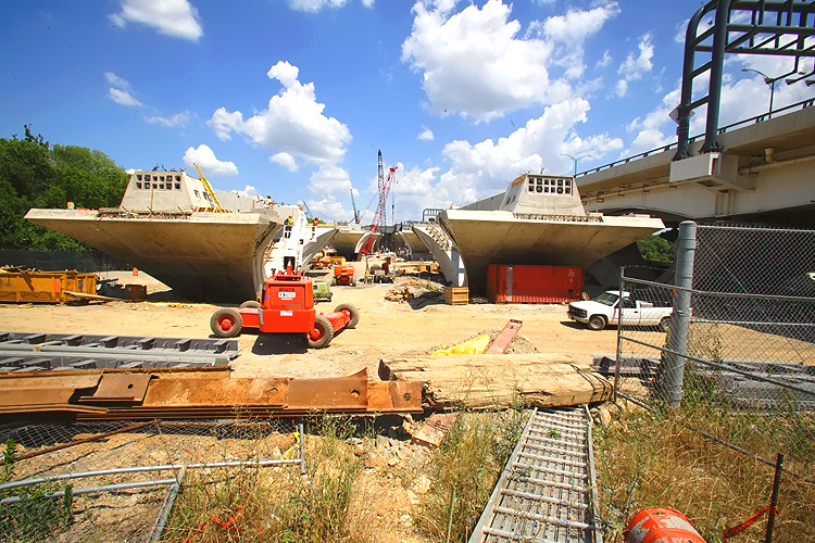 |
Potomac River Bridge construction, the Virginia Approach Spans construction of the 6-lane Inner Loop bridge, looking from the Virginia abutment (terminal structure) of the new bridge, toward the set of V-piers closest to the abutment. The completed 6-lane Outer Loop WWB is visible to the right. |
Lead article - Woodrow Wilson Bridge Project Photos
This article was released on July 1, 2007, with the first 26 aerial photos, numbered 01 thru 25 (and a zoom-in excerpt for #22). The 26 aerial photos, numbered 26 thru 51, were added on July 6, 2007. The last 26 ground-level photos were added on July 22, 2007.
Copyright © 2007 by Scott Kozel. All rights reserved. Reproduction, reuse, or distribution without permission is prohibited.
By Scott M. Kozel, Capital Beltway dot com, Roads to the Future
(Created 7-1-2007, last updated 7-22-2007)