
| Woodrow Wilson Bridge Project Photos - June 2005 |
The following 69 photos show various aerial views of the I-95/I-495 Woodrow Wilson Bridge (WWB) Project construction, including the new Potomac River Bridge under construction, the new U.S. Route 1 Interchange under construction, the Washington Street Urban Deck construction, and the Maryland Interstate 295 Interchange construction.
These photos were taken on June 16, 2005, by the Virginia Department of Transportation, and are posted here with their permission, and Roads to the Future utilized Adobe PhotoDeluxe Business Edition to brighten all the photos and to align and crop some of the photos. Click on the photo to get a large version of the photo. In later versions of Netscape and Internet Explorer, you probably will need to use Full Screen mode (the F11 key can be utilized to swap back and forth between Full Screen and Regular) to see the full size of the large photo without browser-induced image shrinkage. The large photos have sizes ranging from 255 to 557 kilobytes, with most of them being under 456 kilobytes. With a broadband or network Internet connection each photo will download within seconds, but with a dial-up Internet connection it will be somewhat slower.
The day was partly cloudy when the photos were taken, so some of the photos have lighter and darker areas.
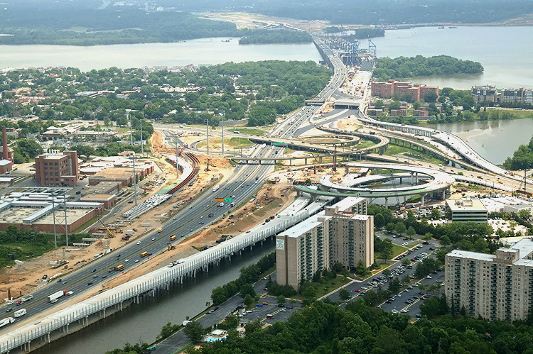 |
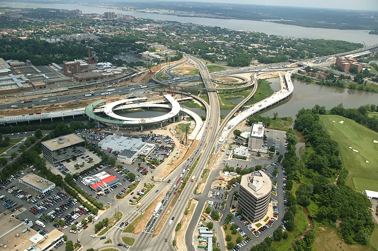
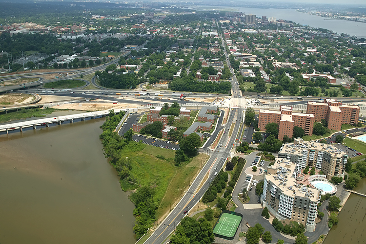
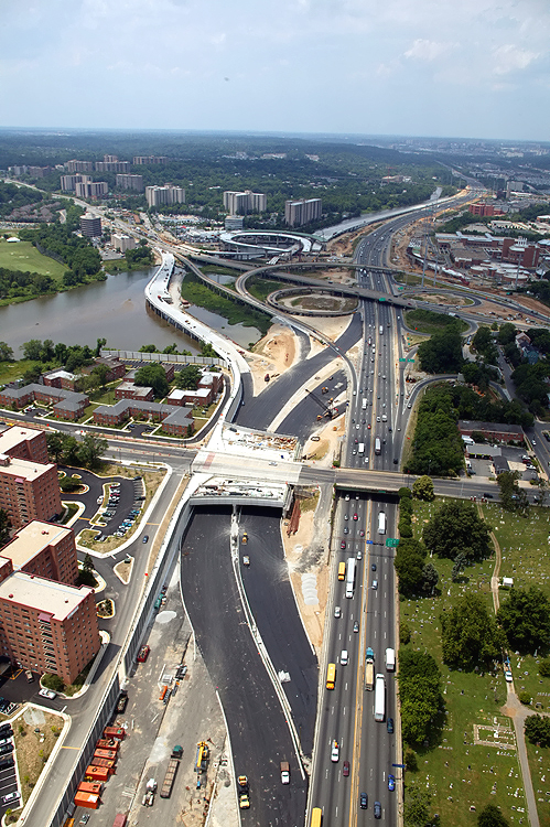
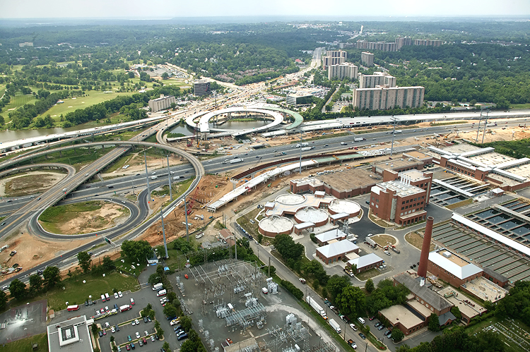
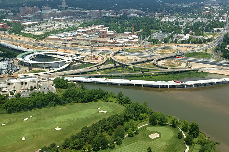
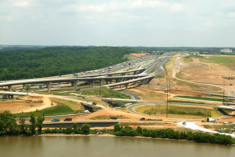
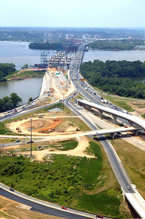
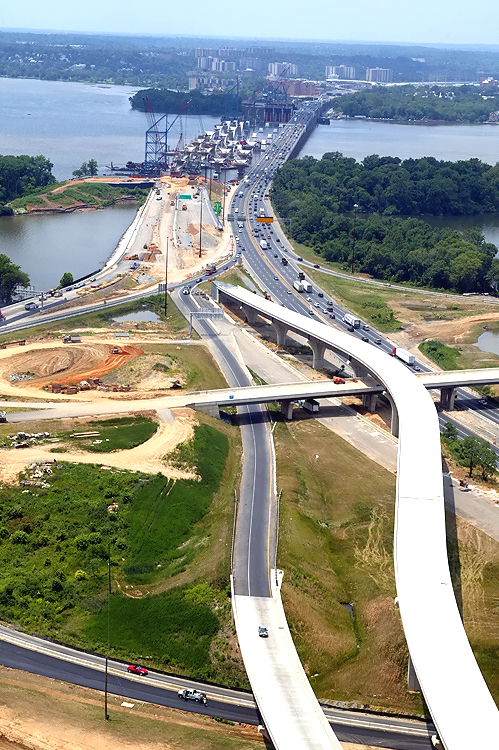
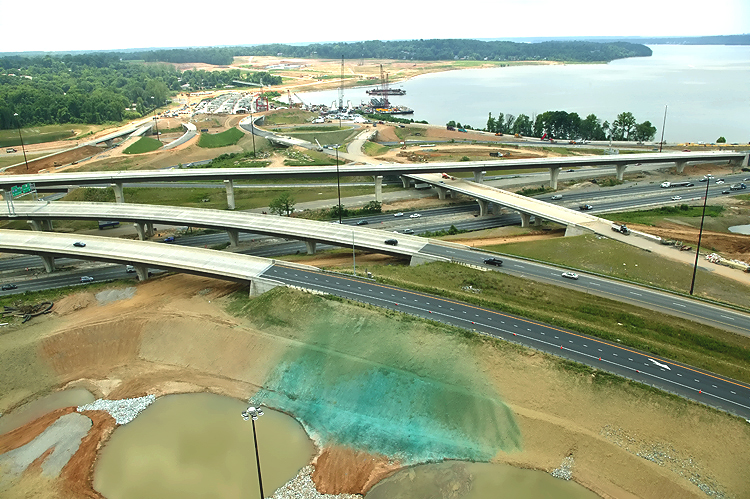
U.S. Route 1 Interchange construction, looking east across Hunting Creek (also known as Cameron Run), and the 8-lane I-95/I-495 Capital Beltway, with Alexandria on the north side of the Beltway, and the Potomac River and 6-lane Woodrow Wilson Bridge is visible in the distance. The long new bridge under construction on the near side of the Beltway, is part of the US Route 1 Interchange Advanced Bridge contract, and the bridge will carry the Beltway Outer Loop local roadway. The cleared area on both sides of the Beltway is for the widened highway, and one of the sites of the US Route 1 Interchange Ground Improvement contract. |
 |
U.S. Route 1 Interchange construction, looking east across Hunting Creek, and the I-95/I-495 Capital Beltway, with Alexandria on the north side of the Beltway. This is a closer view of the right center portion of the previous photo. US-1 runs generally left to right in this photo. The bridges in the lower left corner, the loop ramp under construction, and the outer ramp under construction on the far side of US-1, are parts of the US Route 1 Interchange Advanced Bridge contract, which is nearly complete. |
 |
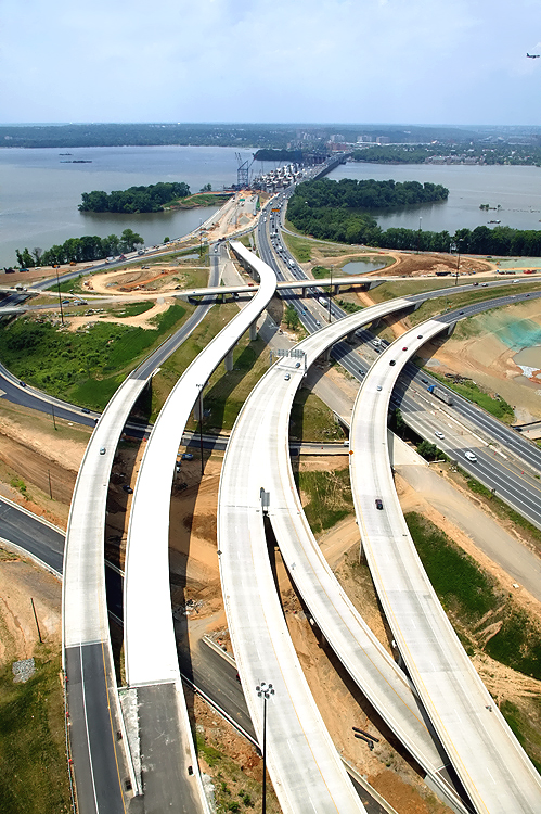
U.S. Route 1 Interchange construction, looking east across Hunting Creek, and the I-95/I-495 Capital Beltway, with Alexandria on the north side of the Beltway. This photo was taken from over US-1, and the new ramps under construction can be seen on either side of US-1. |
 |
U.S. Route 1 Interchange construction, looking northeast across Hunting Creek, and the I-95/I-495 Capital Beltway, with Alexandria on the north side of the Beltway. This photo was taken from over US-1, and the new ramps under construction can be seen on either side of US-1. Nearly all of the southern half of the original US-1/I-495 interchange was built on bridge structure to span the creek and low-lying ground areas, and US-1 itself is on a bridge from south of the creek to just north of the Beltway. |
 |
U.S. Route 1 Interchange construction, looking north across Hunting Creek, and the I-95/I-495 Capital Beltway, with Alexandria on the north side of the Beltway. This photo was taken from over US-1. |
 |
U.S. Route 1 Interchange construction, looking north across Hunting Creek, and the I-95/I-495 Capital Beltway, with Alexandria on the north side of the Beltway. This photo was taken from over US-1, and the new ramps under construction can be seen on either side of US-1. |
 |
U.S. Route 1 Interchange construction, looking north across Hunting Creek, and the I-95/I-495 Capital Beltway, with Alexandria on the north side of the Beltway. The new ramps under construction can be seen on either side of US-1. The new ramp from US-1 northbound to the Outer Loop of the Beltway, can be seen under construction in the center of the photo, and this bridged ramp will have a separate pedestrian/bicycle trail on the outside of the bridge, and the trail will carry pedestrian/bicycle traffic between US-1 south of Alexandria and Washington Street and the pedestrian/bicycle trail which will cross the Potomac River on the new Woodrow Wilson Bridge to pedestrian/bicycle trails in Maryland. |
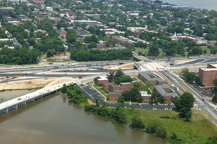 |
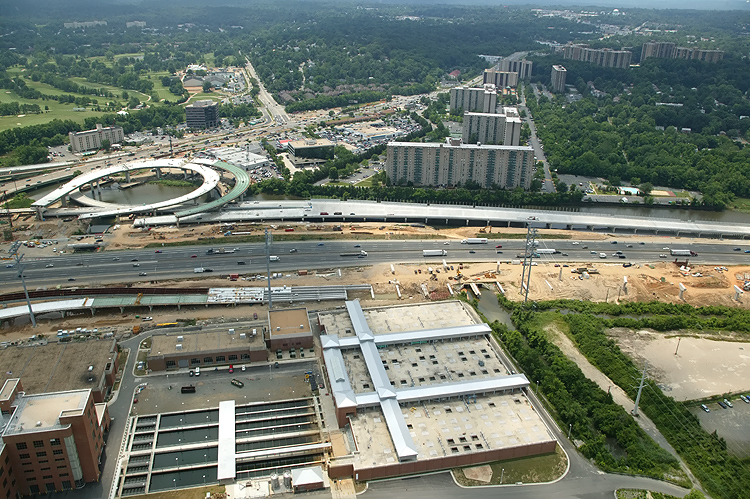
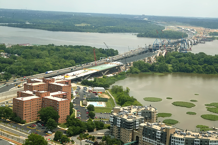
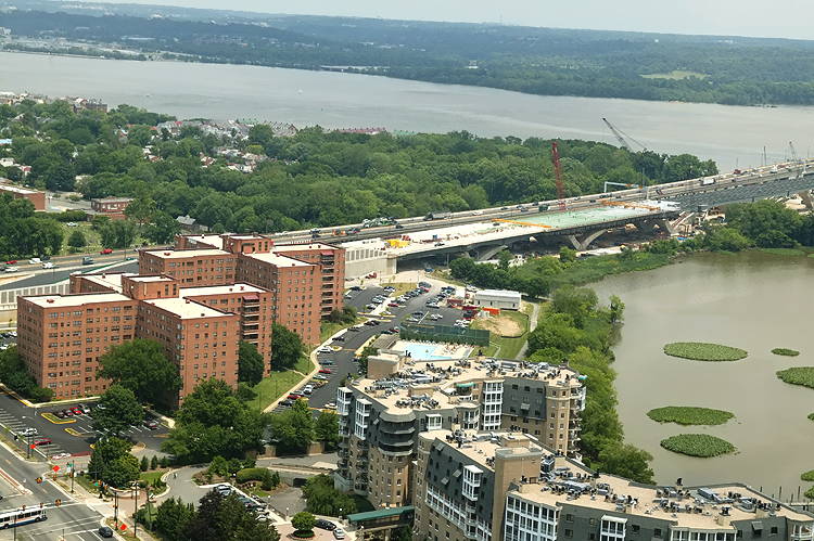
The Hunting Point apartment buildings and office buildings are visible in the center of the photo, and the under construction Washington Street Urban Deck is visible as it crosses the Beltway. |
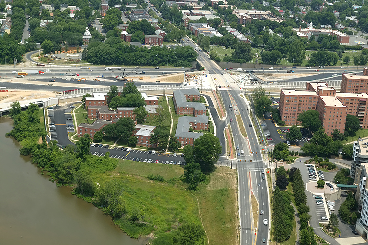 |
Mount Vernon Memorial Highway runs from the bottom of the photo, upward past the apartment complex where the Mount Vernon Memorial Highway becomes Washington Street, and Washington Street crosses the Beltway and goes into Old Town Alexandria. The Beltway runs left-right across the center of the photo. |
 |
Mount Vernon Memorial Highway runs from the bottom of the photo, upward past the apartment complex where the Mount Vernon Memorial Highway becomes Washington Street, and Washington Street crosses the Beltway and goes into Old Town Alexandria. The Beltway runs left-right across the center of the photo. The Potomac River and Washington, D.C. is in the distance. |
 |
U.S. Route 1 Interchange construction, looking southwest across Hunting Creek, and the I-95/I-495 Capital Beltway, with Alexandria on the north side of the Beltway. This photo was taken from over the Hunting Point complex. |
 |
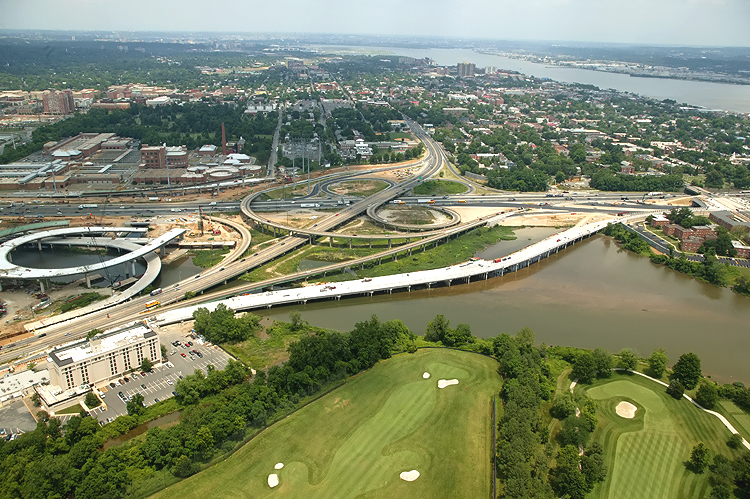
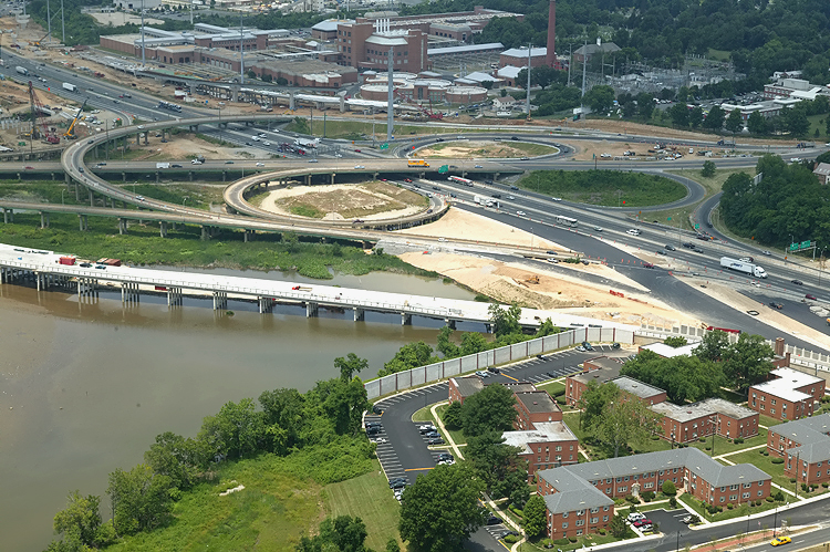
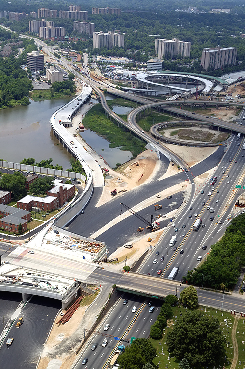
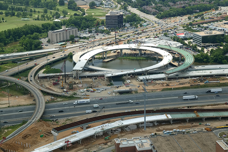
Virginia approach construction, looking southwest, showing construction of the Washington Street Urban Deck in Alexandria VA, and the U.S. Route 1 Interchange in the distance, with a Beltway temporary roadway (details below) nearing completion. Hunting Point apartment towers are visible in foreground. |
 |
Virginia approach construction, looking west, showing construction of the Washington Street Urban Deck in Alexandria VA, and the U.S. Route 1 Interchange in the distance, with a Beltway temporary roadway (details below) nearing completion. |
 |
Virginia approach construction, looking west, showing construction of the Washington Street Urban Deck in Alexandria VA, and the U.S. Route 1 Interchange in the distance, with a Beltway temporary roadway (details below) nearing completion. |
 |
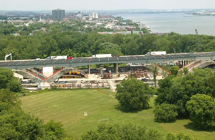
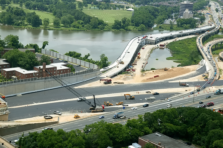
Virginia approach construction, looking west, showing construction of the Washington Street Urban Deck in Alexandria VA, and the U.S. Route 1 Interchange in the distance. The new highway's retaining walls close to the buildings are complete, and the Washington Street Deck has been completed over the future local and express Beltway Outer Loop roadways. Washington Street is the arterial road that crosses the Beltway, and its traffic is being maintained during construction over the Beltway. The completed Washington Street Deck will span the entire reconstructed 12-lane Beltway, and the deck will be over 200 feet long and over 200 feet wide, and will carry the 4-lane divided Washington Street with landscaping over the rest of the deck. The noise barriers over 30 feet high, adjacent to the Hunting Towers Apartment buildings, will be completed before this new section of highway opens. The top half of the temporary roadway in the photo, was already planned in the original "Tie-in Contract" (WWB Project US Route 1 Interchange Tie-In contract), which includes constructing the Washington Street Deck and all Beltway reconstruction between a couple hundred yards west of Washington Street, and the new Woodrow Wilson Bridge Virginia abutments. That portion of the temporary roadway is being built to temporarily tie the existing Beltway into the new 6-lane Outer Loop Woodrow Wilson Bridge, where starting in about May 2006, 6-lane Beltway traffic will flow until the new 6-lane Inner Loop Woodrow Wilson Bridge is completed about May 2008 along with the reconstructed 12-lane land approaches. The lower half of the temporary roadway in the photo, was recently added to the contract so that traffic can be shifted this summer, and then the other half of the Washington Street Deck can be constructed after that section of the existing Beltway roadways are demolished, to benefit the City of Alexandria and the entire Virginia Program, with an early finish to the Urban Deck and completion of South Washington Street. |
 |
Virginia approach construction, looking west, showing construction of the Washington Street Urban Deck in Alexandria VA, and the U.S. Route 1 Interchange in the distance, with a Beltway temporary roadway (details above) nearing completion. |
 |
Virginia approach construction, looking west, showing closer view of the
construction of the Washington Street Urban Deck in Alexandria VA, and
the U.S. Route 1 Interchange. The new ramp from US-1 northbound to the Outer Loop of the Beltway, can be seen under construction in the left center of the photo, and this bridged ramp will have a separate pedestrian/bicycle trail on the outside of the ramp, and the trail will carry pedestrian/bicycle traffic between US-1 south of Alexandria and Washington Street and the pedestrian/bicycle trail which will cross the Potomac River on the new Woodrow Wilson Bridge to pedestrian/bicycle trails in Maryland. |
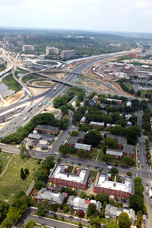 |
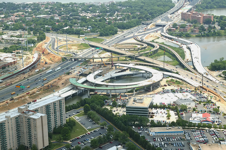
U.S. Route 1 Interchange construction, looking southeast across the I-95/I-495 Capital Beltway, with Alexandria on the north side of the Beltway. This photo was taken from over Old Town Alexandria. |
 |
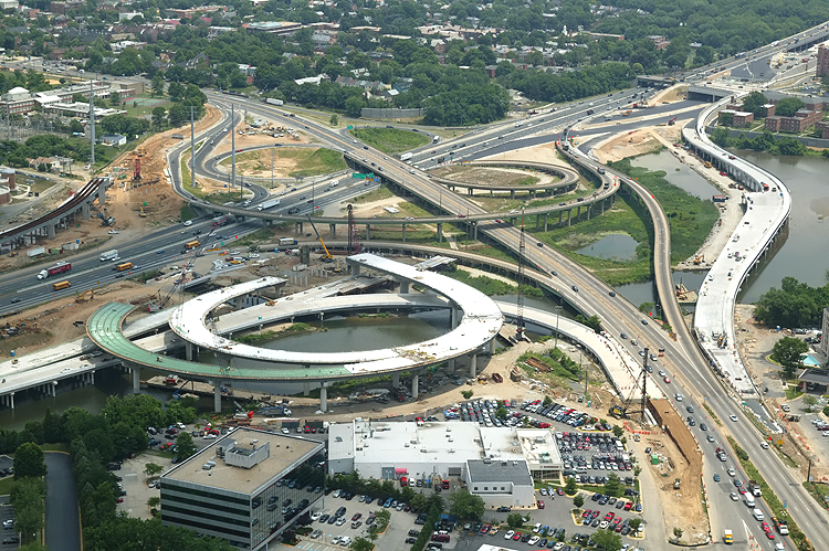
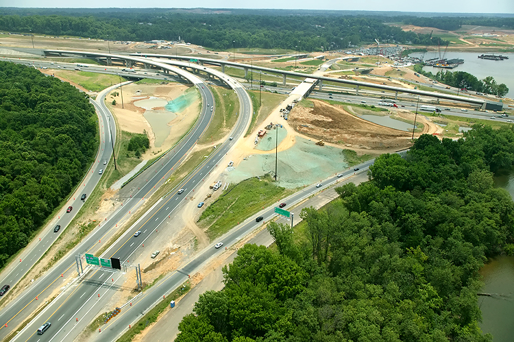
U.S. Route 1 Interchange construction, looking south along U.S. Route 1 which goes into the distance, with the Beltway running left-right. The original U.S. Route 1 Interchange has a considerable amount of bridgework across areas of water and low-lying land, with a long bridge on U.S. 1 and bridges on four of the ramps. The interchange seen here is in essentially the same format as when it opened to traffic in 1961, with a modified cloverleaf design with a semi-directional ramp connecting southbound U.S. 1 to northbound I-95/I-495, and with a collector-distributor (C-D) roadway intercepting the two loop ramps on southbound I-95/I-495. |
 |
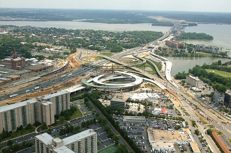
U.S. Route 1 Interchange construction, looking south, with the Beltway running left-right. |
 |
U.S. Route 1 Interchange construction, looking south across the I-95/I-495 Capital Beltway and Hunting Creek. The ramp bridges under construction are part of the US Route 1 Interchange Advanced Bridge contract. |
 |
U.S. Route 1 Interchange construction, looking south across the I-95/I-495 Capital Beltway and Hunting Creek. The ramp bridges under construction are part of the US Route 1 Interchange Advanced Bridge contract. |
 |
U.S. Route 1 Interchange construction, looking east down Hunting Creek (also known as Cameron Run), and the 8-lane I-95/I-495 Capital Beltway, with Alexandria on the north side of the Beltway, and the Potomac River and 6-lane Woodrow Wilson Bridge is visible in the distance. The long new bridge under construction on the near side of the Beltway, is part of the US Route 1 Interchange Advanced Bridge contract, and the bridge will carry the Beltway Outer Loop local roadway. The cleared area on both sides of the Beltway is for the widened highway, and one of the sites of the US Route 1 Interchange Ground Improvement contract. |
 |
U.S. Route 1 Interchange construction, looking east across Hunting Creek (also known as Cameron Run), and the 8-lane I-95/I-495 Capital Beltway, with Alexandria on the north side of the Beltway, and the Potomac River and 6-lane Woodrow Wilson Bridge is visible in the distance. The bridges in the lower left corner, the loop ramp under construction, and the outer ramp under construction on the far side of US-1, are parts of the US Route 1 Interchange Advanced Bridge contract, which is nearly complete. |
 |
U.S. Route 1 Interchange construction, looking north across Hunting Creek, and the I-95/I-495 Capital Beltway, with Alexandria on the north side of the Beltway. The new ramps under construction can be seen on either side of US-1. The new ramp from US-1 northbound to the Outer Loop of the Beltway, can be seen under construction in the center of the photo, and this bridged ramp will have a separate pedestrian/bicycle trail on the outside of the bridge, and the trail will carry pedestrian/bicycle traffic between US-1 south of Alexandria and Washington Street and the pedestrian/bicycle trail which will cross the Potomac River on the new Woodrow Wilson Bridge to pedestrian/bicycle trails in Maryland. |
 |
Virginia approach construction, looking west, showing closer view of the south portion of the U.S. Route 1 Interchange. The new ramp from US-1 northbound to the Outer Loop of the Beltway, can be seen under construction in the left center of the photo, and this bridged ramp will have a separate pedestrian/bicycle trail on the outside of the ramp, and the trail will carry pedestrian/bicycle traffic between US-1 south of Alexandria and Washington Street and the pedestrian/bicycle trail which will cross the Potomac River on the new Woodrow Wilson Bridge to pedestrian/bicycle trails in Maryland. |
 |
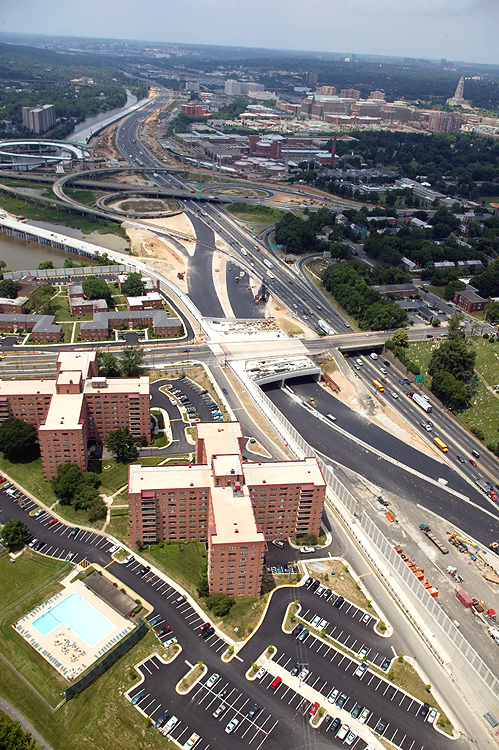
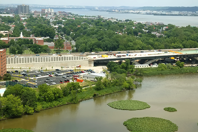
Virginia approach construction, looking east, showing construction of the Washington Street Urban Deck in Alexandria VA, and the existing and under construction Woodrow Wilson Bridges in the distance. The new highway's retaining walls close to the buildings are complete, and the Washington Street Deck has been completed over the future local and express Beltway Outer Loop roadways. Washington Street is the arterial road that crosses the Beltway, and its traffic is being maintained during construction over the Beltway. The completed Washington Street Deck will span the entire reconstructed 12-lane Beltway, and the deck will be over 200 feet long and over 200 feet wide, and will carry the 4-lane divided Washington Street with landscaping over the rest of the deck. The noise barriers over 30 feet high, adjacent to the Hunting Towers Apartment buildings, will be completed before this new section of highway opens. The lower half of the temporary roadway in the photo, was already planned in the original "Tie-in Contract" (WWB Project US Route 1 Interchange Tie-In contract), which includes constructing the Washington Street Deck and all Beltway reconstruction between a couple hundred yards west of Washington Street, and the new Woodrow Wilson Bridge Virginia abutments. That portion of the temporary roadway is being built to temporarily tie the existing Beltway into the new 6-lane Outer Loop Woodrow Wilson Bridge, where starting in about May 2006, 6-lane Beltway traffic will flow until the new 6-lane Inner Loop Woodrow Wilson Bridge is completed about May 2008 along with the reconstructed 12-lane land approaches. The upper half of the temporary roadway in the photo, was recently added to the contract so that traffic can be shifted this summer, and then the other half of the Washington Street Deck can be constructed after that section of the existing Beltway roadways are demolished. |
 |
Virginia approach construction, looking east, showing construction of the Washington Street Urban Deck in Alexandria VA, and the existing and under construction Woodrow Wilson Bridges in the distance, with a Beltway temporary roadway (details above) nearing completion. |
 |
Virginia approach construction, looking east, showing construction of the Washington Street Urban Deck in Alexandria VA, and the existing and under construction Woodrow Wilson Bridges in the distance, with a Beltway temporary roadway (details above) nearing completion. |
 |
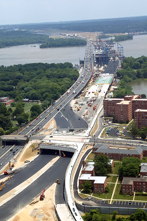
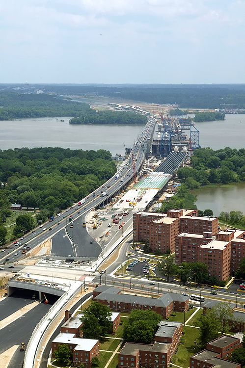
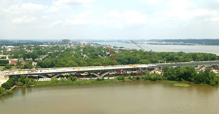
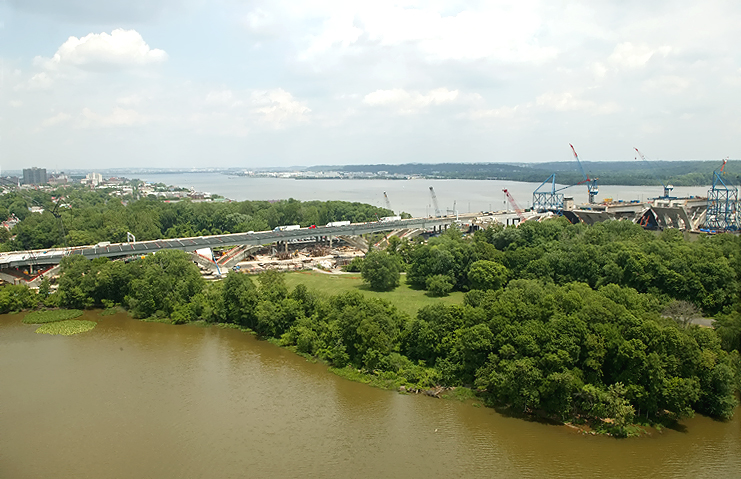
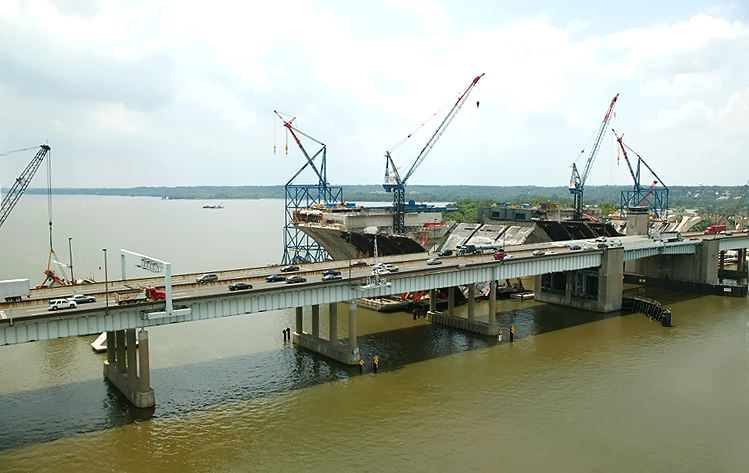
Potomac River Bridge construction, with the existing and under construction Woodrow Wilson Bridges fully shown. Looking from over Virginia, across the Hunting Point apartment and condominium complex, across the Potomac River, with Maryland on the opposite side of the river. |
 |
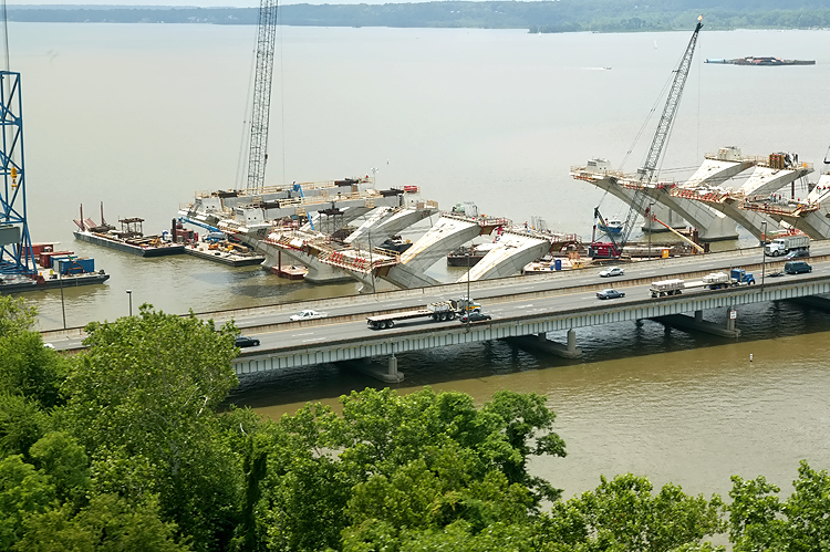
Potomac River Bridge construction, similar vantage point as previous photo, closer view of the WWB Virginia Approach Spans construction (contract Potomac River Bridge Virginia Approach Spans). |
 |
Virginia approaches construction to the Potomac River Bridge, looking north. Construction in the right of the photo is the Potomac River Bridge Virginia Approach Spans contract. The new Virginia abutment for the Potomac River Bridge is visible in the center of the photo. The existing Woodrow Wilson Bridge and Old Town Alexandria and the Potomac River are visible in the upper part of the photo. |
 |
Virginia approaches construction to the Potomac River Bridge, looking north. Construction in the center of the photo is the Potomac River Bridge Virginia Approach Spans contract. The existing Woodrow Wilson Bridge and Old Town Alexandria and the Potomac River are visible in the upper part of the photo. The new Virginia abutment for the Potomac River Bridge is visible in the left of the photo. Jones Point is visible in the right of the photo. Several spans have been built for the new Potomac River Bridge for the Beltway Outer Loop. |
 |
Potomac River Bridge construction, looking north, across Jones Point, at the Virginia Approach construction, and the Bascule Span construction. The new 12-lane twin-span bridge is being built just to the south of the existing 6-lane bridge. |
 |
Potomac River Bridge construction, looking north, across Jones Point, at the Virginia Approach construction, and the Bascule Span construction. |
 |
Potomac River Bridge construction, looking north, across Jones Point, at the Virginia Approach construction. Similar vantage point as previous photo, but telephoto. |
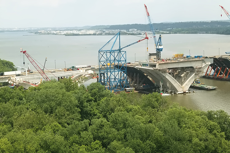 |
Potomac River Bridge construction, looking north from Virginia shoreline, view of the Bascule Span construction, which is being built under the Potomac River Bridge Bascule Spans contract. |
 |
Potomac River Bridge construction, view of the Bascule Span construction, which is being built under the Potomac River Bridge Bascule Spans contract. |
 |
Potomac River Bridge construction, closer view of the Bascule Span construction. Looking north, downtown D.C. is in the distance, and Old Town Alexandria is on the left. |
 |
Potomac River Bridge construction, looking north, view of the Maryland Approach Spans construction, which is being built under the Potomac River Bridge Maryland Approach Spans contract. The beginnings of delta pier construction is underway on the bridge foundation in the center of the photo. The foundations were built in the Potomac River Bridge Foundations contract. |
 |
Potomac
River Bridge construction, looking north, view of the Maryland Approach
Spans construction. Delta pier construction is underway on the
bridge foundation in the center of the photo.
The delta piers on the approach spans are being constructed via the precast segmental method, whereby reinforced concrete segments are fabricated in a fabrication yard, and assembled on the pier foundations and post-tensioned with steel cables that pass through channels in the piers. |
 |
Potomac
River Bridge construction, looking north, view of the Maryland Approach
Spans construction. Delta pier construction is underway on the
bridge foundations.
The existing 6-lane Woodrow Wilson Bridge is visible on the opposite side of the new bridge construction. |
 |
Potomac River Bridge construction, looking north, view of the Maryland Approach Spans construction. Delta pier construction is underway on the bridge foundations. |
 |
Potomac River Bridge construction, looking north, view of the Maryland Approach Spans construction. Delta pier construction is underway on the bridge foundations. The under construction Maryland abutment for the new Potomac River Bridge is visible in the right of the photo. |
 |
Interstate 295 Interchange construction, looking east, the Potomac River bridge is just off of the left edge of the photo, and the I-95/I-495 Beltway sweeps into the distance. |
 |
Interstate 295 Interchange construction, looking east, the I-95/I-495 Beltway sweeps into the distance. |
 |
Interstate 295 Interchange construction, looking north. High capacity roadways and ramps are being constructed to make this a 4-way interchange, with the southerly extension heading into the National Harbor development which began construction in 2004. Website for National Harbor. |
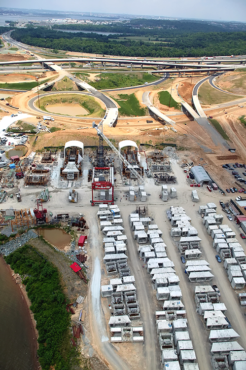 |
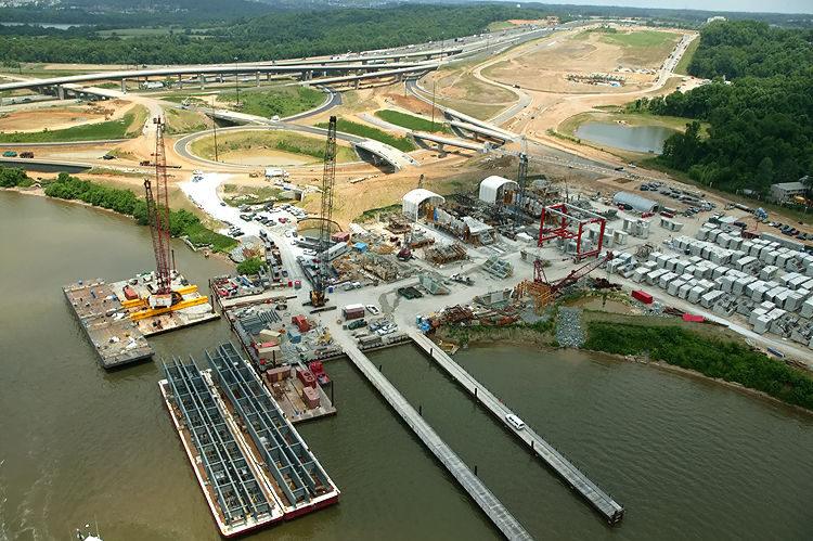
Interstate 295 Interchange construction, looking north, the south section of the interchange that heads into the property of the National Harbor development. The center and lower part of the photo shows the fabrication yard for the pre-casting of the segments that are being utilized for the piers on the Potomac River Bridge Maryland Approach Spans construction. This fabrication yard is visible in the previous photo, and the previous photo shows the Potomac River docks for barges that transport materials to the project. |
 |
Interstate 295 Interchange construction, looking north. The I-95/I-495 Beltway runs left-right, and I-295 is seen as it sweeps upward, to the center of Washington, D.C. |
 |
Interstate 295 Interchange construction, looking northwest. The I-95/I-495 Beltway runs left-right, the Woodrow Wilson Bridge is in the upper left corner, and Virginia is on the opposite side of the Potomac River. |
 |
Interstate 295 Interchange construction, looking west. The I-95/I-495 Beltway runs up-down, the Woodrow Wilson Bridge is in the upper part of the photo, and Virginia is on the opposite side of the Potomac River |
 |
Interstate 295 Interchange construction, looking west. The I-95/I-495 Beltway runs up-down, the Woodrow Wilson Bridge is in the upper part of the photo, and Virginia is on the opposite side of the Potomac River. |
 |
Interstate 295 Interchange construction, looking west. The I-95/I-495 Beltway runs up-down, the Woodrow Wilson Bridge is in the upper part of the photo, and Virginia is on the opposite side of the river. The right two new bridges extend I-295 to MD-210 Indian Head Highway, and the left two new bridges connect the Beltway Outer Loop to MD-210 Indian Head Highway. |
 |
Interstate 295 Interchange construction,
looking southwest. The I-95/I-495 Beltway runs left-right, the Woodrow
Wilson Bridge is in the right part of the photo, and Virginia is on the
opposite side of the Potomac River.
|
 |
Interstate 295 Interchange construction, looking south. The I-95/I-495 Beltway runs left-right, the Woodrow Wilson Bridge is off of the right part of the photo, and the National Harbor construction is in the upper part of the photo. |
 |
Interstate 295 Interchange construction, looking south. The I-95/I-495 Beltway runs left-right, I-295 goes to/from the left lower corner of the photo, and the National Harbor construction is in the upper part of the photo. |
 |
Interstate 295 Interchange construction, looking south. The I-95/I-495 Beltway runs left-right, the Woodrow Wilson Bridge is off of the right part of the photo, and the National Harbor construction is in the upper part of the photo. |
 |
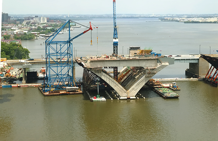
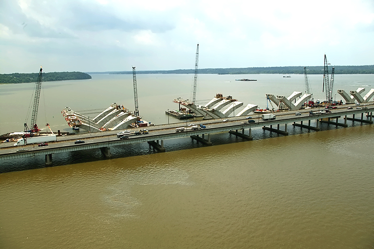
Potomac
River Bridge construction, looking south, view of the Maryland Approach
Spans construction, near the Maryland shoreline. The delta piers on the approach spans are being constructed via the pre-cast segmental method, whereby reinforced concrete segments are fabricated in a fabrication yard, and assembled on the pier foundations and post-tensioned with steel cables that pass through channels in the piers. The arches are held in place by temporary steel cables until the reinforced concrete cross-member links the two arches. The bridge's steel beams and roadway deck will be constructed across the top of the piers. |
 |
Potomac
River Bridge construction, looking south, view of the Maryland Approach
Spans construction, near the Maryland shoreline. The existing 6-lane Woodrow Wilson Bridge is visible on the near side of the new bridge construction. |
 |
Potomac River Bridge construction, looking south, view of the Maryland Approach Spans construction, which is being built under the Potomac River Bridge Maryland Approach Spans contract. |
 |
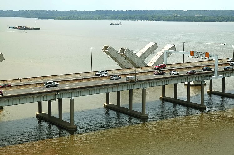
Potomac River Bridge construction, looking south, view of the Bascule Span construction, which is being built under the Potomac River Bridge Bascule Spans contract. The bascule span of the existing bridge, is visible in the right of the photo. |
 |
Potomac River Bridge construction, looking south, view of the Bascule Span construction. The bascule span of the existing bridge, is visible in the lower left of the photo. |
 |
Potomac River Bridge construction, looking south, view of the Bascule Span construction. The bascule span of the existing bridge, is visible in the lower left of the photo. |
 |
Construction in the center of the photo is the Potomac River Bridge Virginia Approach Spans contract. The existing Woodrow Wilson Bridge is on the near side of the construction. Jones Point is visible in the upper center of the photo. This photo is panned just to the right from the previous photo. |
 |
Potomac River Bridge Virginia Approach Spans construction. The existing Woodrow Wilson Bridge is on the near side of the construction. Jones Point is visible in the upper left of the photo. This photo is panned just to the right from the previous photo. |
 |
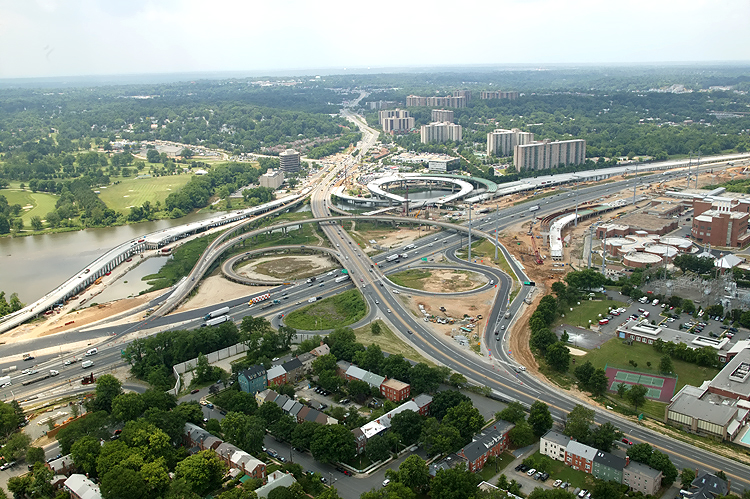
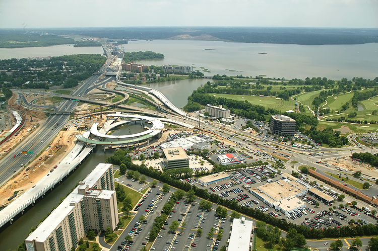
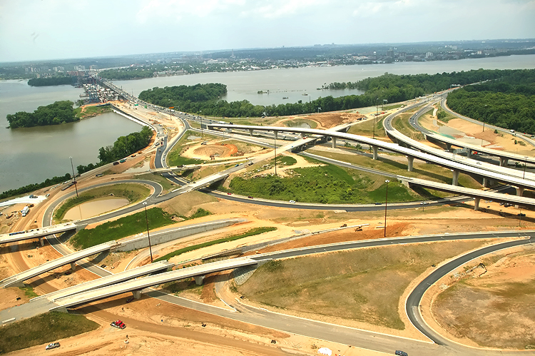
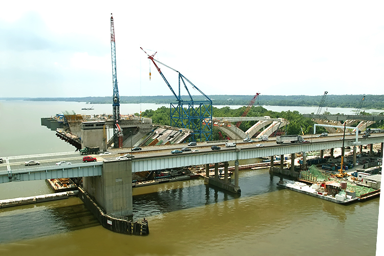
Virginia approaches construction to the Potomac River Bridge, looking south. The new 12-lane twin-span bridge is being built just to the south of the existing 6-lane Woodrow Wilson Bridge. The Hunting Towers apartment complex is in the center of the photo. The Virginia abutment (terminal structure) of the bridges is visible in the center of the photo. |
 |
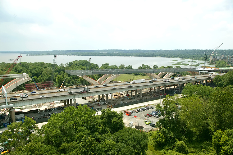
Virginia approaches construction to the Potomac River Bridge, looking south. Looking over Washington Street, across the Beltway and WWB Project, and Washington Street south of the apartments becomes the Mount Vernon Memorial Highway and heads to Mount Vernon. |
 |
Virginia approaches construction to the Potomac River Bridge, looking south. Looking from over Washington Street, across the Beltway and WWB Project. The Washington Street Deck has been completed over the future local and express Beltway Outer Loop roadways. Washington Street is the highway that crosses the Beltway, and its traffic is being maintained during construction over the Beltway. The completed Washington Street Deck will span the entire reconstructed 12-lane Beltway, and the deck will be over 200 feet long and over 200 feet wide, and will carry the 4-lane divided Washington Street with landscaping over the rest of the deck. |
 |
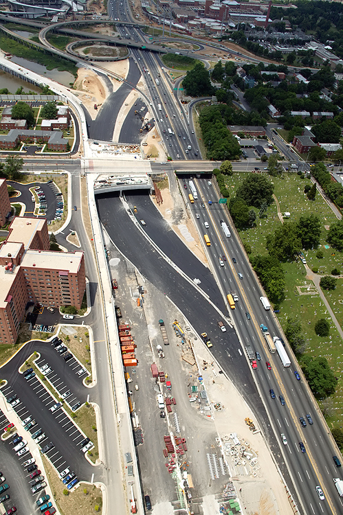
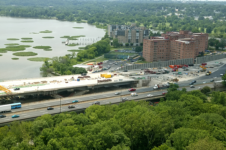
Virginia approach construction, looking south, showing closer view of the
temporary Beltway roadway under
construction. Notice that the highway is depressed, and that the new
retaining wall and sound barrier is complete at the south edge of the
highway near the buildings.
The new ramp from US-1 northbound to the Outer Loop of the Beltway, can be seen under construction in the center of the photo, and this bridged ramp will have a separate pedestrian/bicycle trail on the outside of the ramp, and the trail will carry pedestrian/bicycle traffic between US-1 south of Alexandria and Washington Street and the pedestrian/bicycle trail which will cross the Potomac River on the new Woodrow Wilson Bridge to pedestrian/bicycle trails in Maryland. That trail runs just outside of the top of the retaining wall. |
Lead article - Woodrow Wilson Bridge Project Photos
Copyright © 2005 by Scott Kozel. All rights reserved. Reproduction, reuse, or distribution without permission is prohibited.
By Scott M. Kozel, Capital Beltway dot com, Roads to the Future
(Created 8-1-2005, moved to capital-beltway.com on 3-17-2007)