
| Woodrow Wilson Bridge Project Photos - January 2006 |
The following 75 photos show various aerial views of the I-95/I-495 Woodrow Wilson Bridge (WWB) Project construction, including the new Potomac River Bridge construction, the Virginia U.S. Route 1 Interchange construction, the Washington Street Urban Deck construction, and the Maryland Interstate 295 Interchange construction.
These photos were taken by the Virginia Department of Transportation, and are posted here with their permission. Roads to the Future utilized PhotoDeluxe Business Edition to sharpen and brighten and to align all of the photos. Click on the photo to get a large version of the photo. In later versions of Netscape and Internet Explorer, you probably will need to use Full Screen mode (the F11 key can be utilized to swap back and forth between Full Screen and Regular) to see the full size of the large photo without browser-induced image shrinkage. The large photos have sizes ranging from 80 to 328 kilobytes, with most of them being under 218 kilobytes. With a broadband or network Internet connection each photo will download within seconds, but with a dial-up Internet connection it will be somewhat slower.
The following 37 photos were taken on January 9, 2006, by the Virginia Department of Transportation.
 |
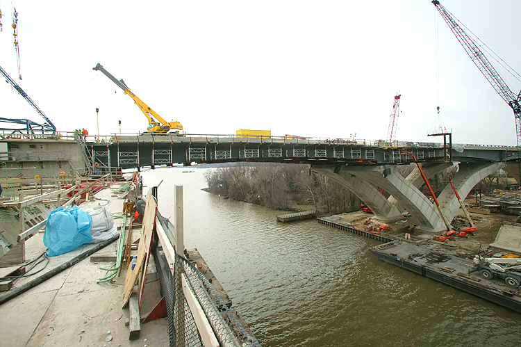
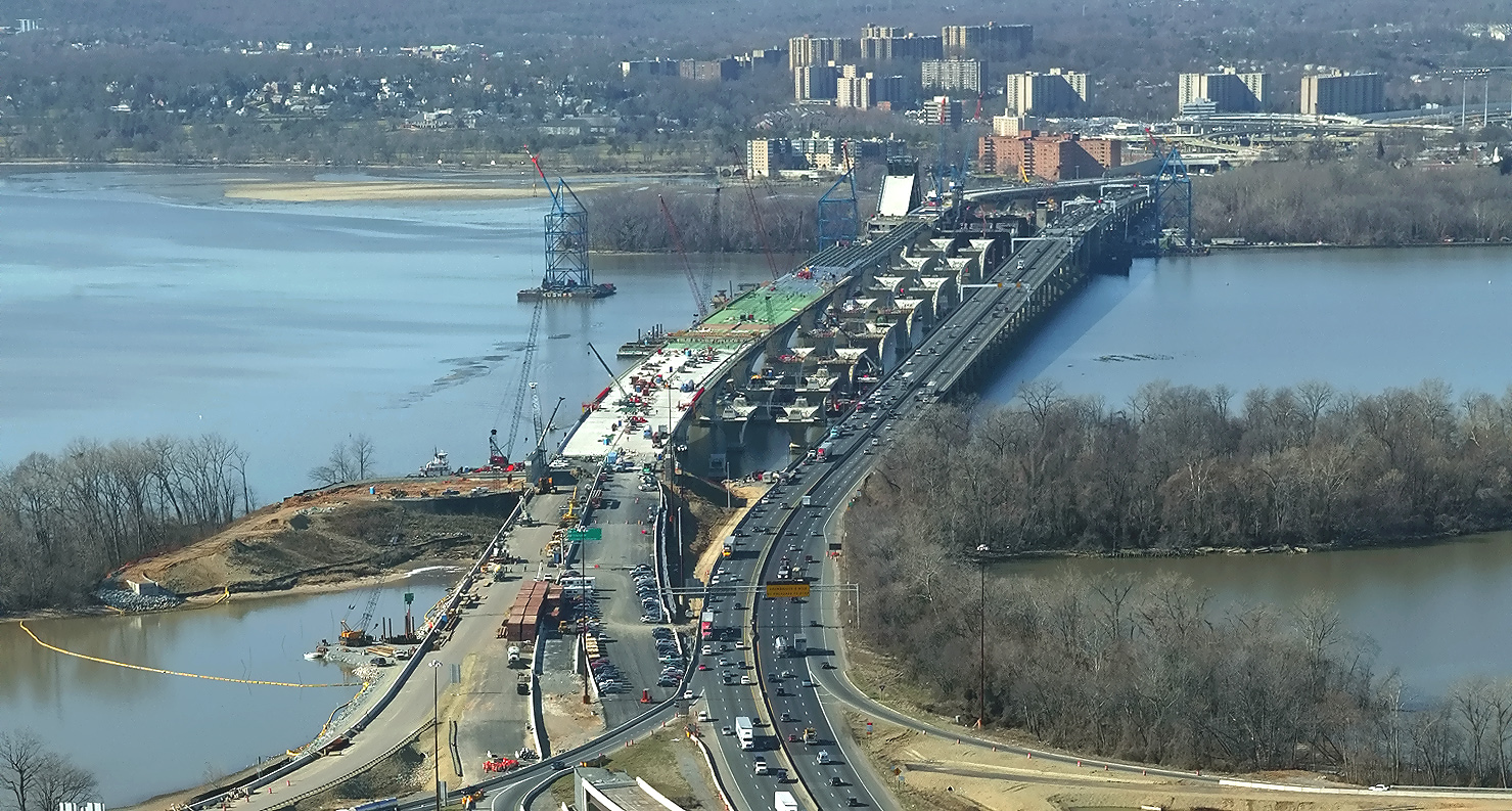
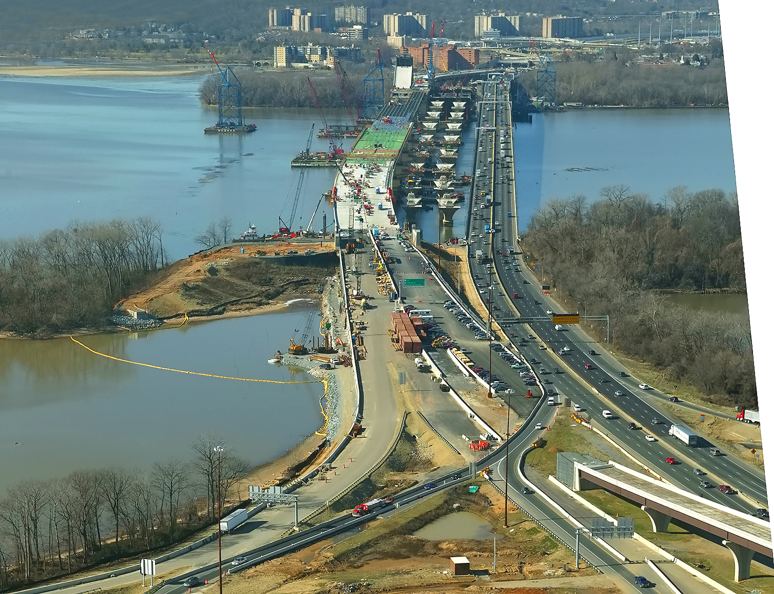
Virginia approaches construction to the Potomac River Bridge, which is being built under the Potomac River Bridge Virginia Approach Spans contract, looking south. |
 |
Virginia approaches construction to the Potomac River Bridge, looking at the span between the Virginia shoreline and the bascule span. |
 |
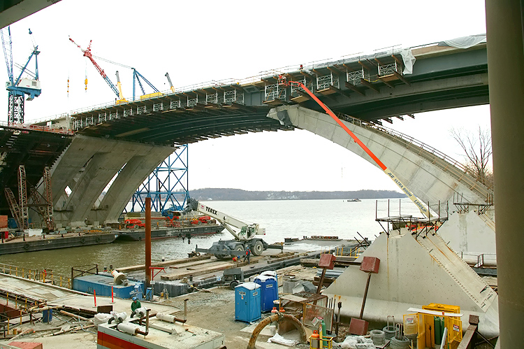
Virginia approaches construction to the Potomac River Bridge, close view of the delta pier connection to the superstructure. |
 |
Virginia approaches construction to the Potomac River Bridge, looking at the span between the Virginia shoreline and the bascule span. |
 |
Virginia approaches construction to the Potomac River Bridge, looking south. |
 |
Virginia approaches construction to the Potomac River Bridge, looking east. |
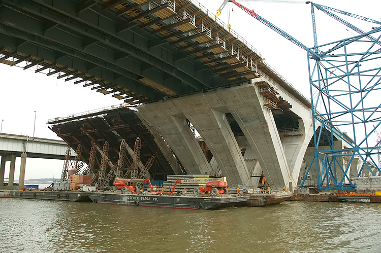 |
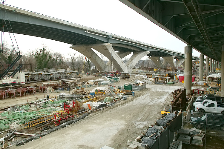
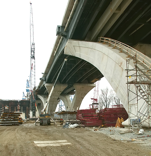
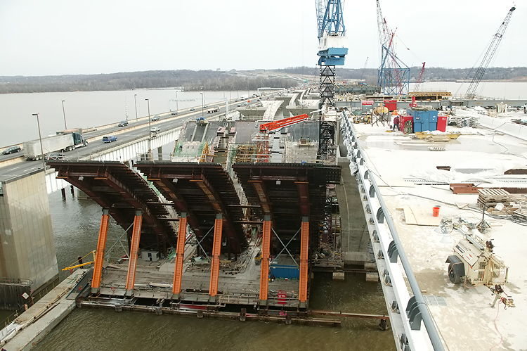
Virginia approaches construction to the Potomac River Bridge, looking at the delta piers for the bascule span. The delta piers for the bascule span are being constructed as cast-in-place reinforced concrete structures. |
 |
Virginia approaches construction to the Potomac River Bridge, looking at the span between the Virginia shoreline and the bascule span. The existing WWB is in the background. |
 |
Virginia approaches construction to the Potomac River Bridge, looking at the span between the Virginia shoreline and the bascule span. |
 |
Virginia approaches construction to the Potomac River Bridge, looking at the span between the Virginia shoreline and the bascule span. |
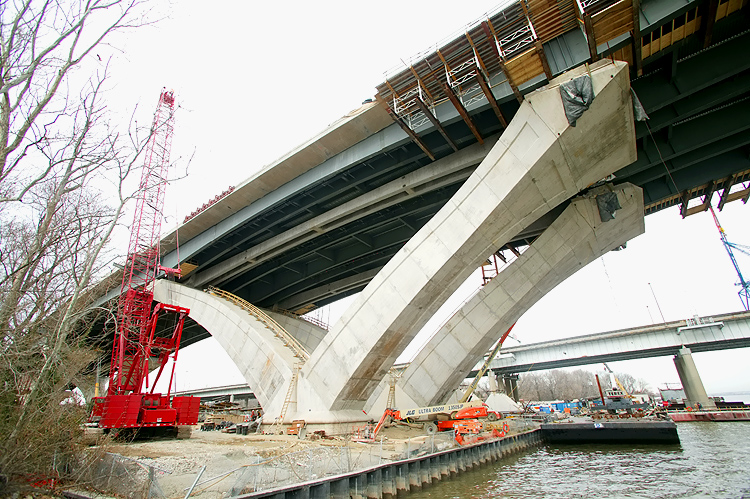 |
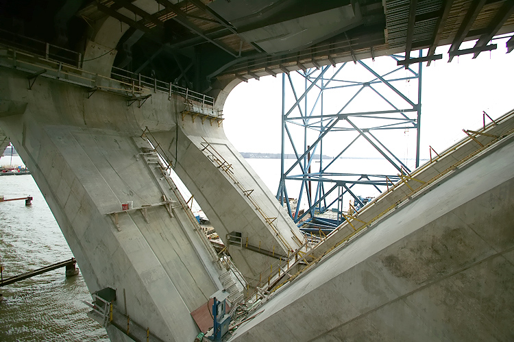
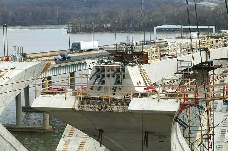
Virginia
approaches construction to the Potomac River Bridge, looking at the delta
pier at the Virginia shoreline. A wide-angle lens exaggerates the perspective.
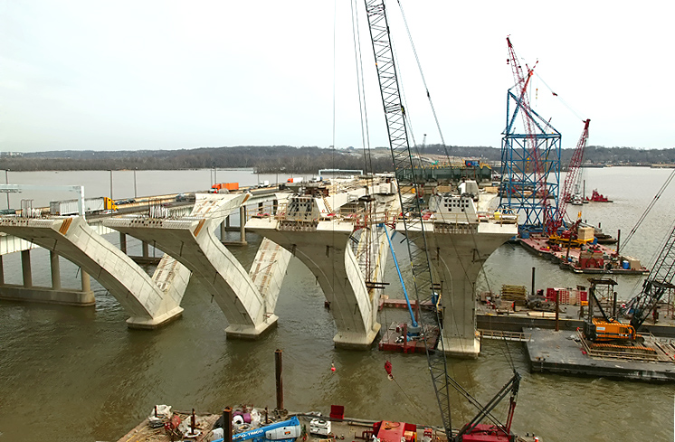
The delta piers on the approach spans are being constructed via the precast segmental method, whereby reinforced concrete segments are cast in a fabrication yard, and assembled on the pier foundations and post-tensioned with steel cables that pass through channels in the piers. The arches are held in place by temporary steel cables until the reinforced concrete cross-member links the two arches. The bridge's steel beams and roadway deck are constructed across the top of the piers. |
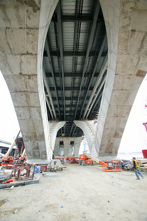 |
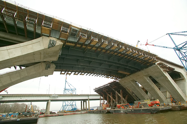
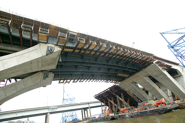
Virginia approaches construction to the Potomac River Bridge, looking at the underside of the new bridge. |
 |
Virginia approaches construction to the Potomac River Bridge, looking at the underside of the new bridge. |
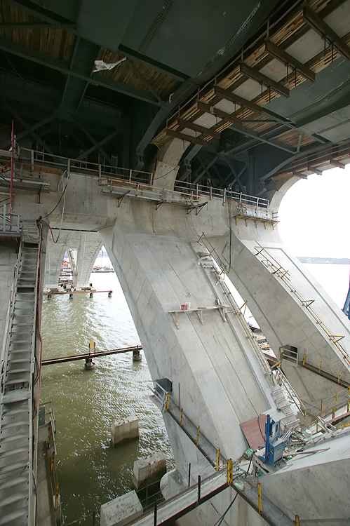 |
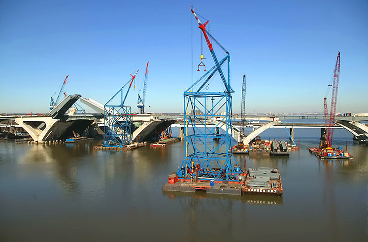
Potomac River Bridge construction, view of the Bascule Span construction, which is being built under the Potomac River Bridge Bascule Spans contract, looking at the inside of the delta piers. The delta piers for the bascule span are being constructed as cast-in-place reinforced concrete structures. |
 |
Potomac River Bridge construction, view of the Bascule Span construction, looking at the inside of the delta piers. |
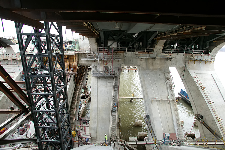 |
Potomac River Bridge construction, view of the Bascule Span construction, looking at the inside of the delta piers. |
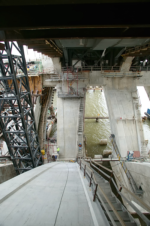 |
Potomac River Bridge construction, view of the Bascule Span construction, looking at the inside of the delta piers. |
 |
Potomac River Bridge construction, view of the Virginia Approach Spans construction, photo taken from the Bascule Span western delta pier. The existing Woodrow Wilson Bridge is to the right. |
 |
Potomac River Bridge construction, view of the Virginia Approach Spans construction, photo taken from the Bascule Span western delta pier. |
 |
Potomac River Bridge construction, view of the Virginia Approach Spans construction, photo taken from the Bascule Span western delta pier, looking south down the Virginia shoreline of the Potomac River. |
 |
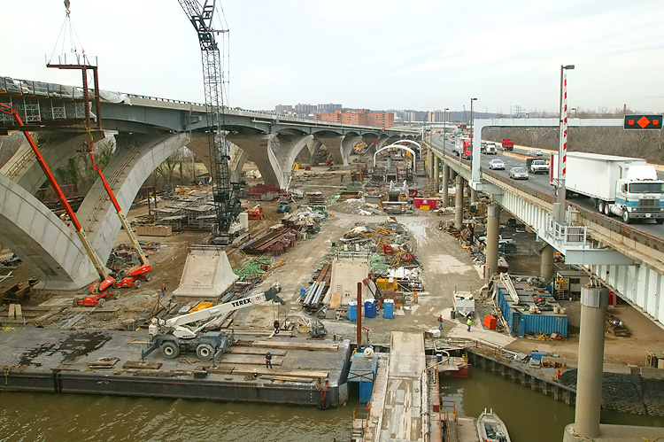
Potomac River Bridge construction, Virginia Approach Spans construction, on a nearly-completed section of the 6-lane Outer Loop bridge. The metal structure is a bridge expansion joint, being installed in the reinforced concrete roadway deck, after which final concrete pours will be conducted along the section where steel reinforcing bars ("re-bars") are visible. |
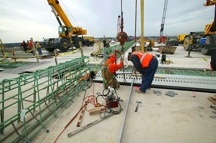 |
Potomac River Bridge construction, Virginia
Approach Spans construction, on a nearly-completed section of the 6-lane
Outer Loop bridge. The metal structure that runs right-to-left is a bridge
expansion joint, being installed in the reinforced concrete roadway deck,
after which final concrete pours will be conducted along the section where
steel reinforcing bars ("re-bars") are visible. The metal structure that runs lower-left-to-center, is the cage of steel reinforcing bars ("re-bars") that will form the core of the concrete median barrier that will separate the 3-lane express roadway from the 3-lane local roadway. |
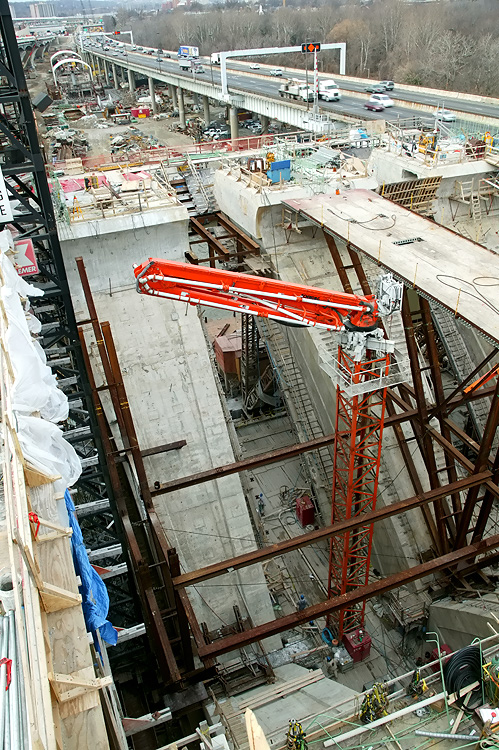 |
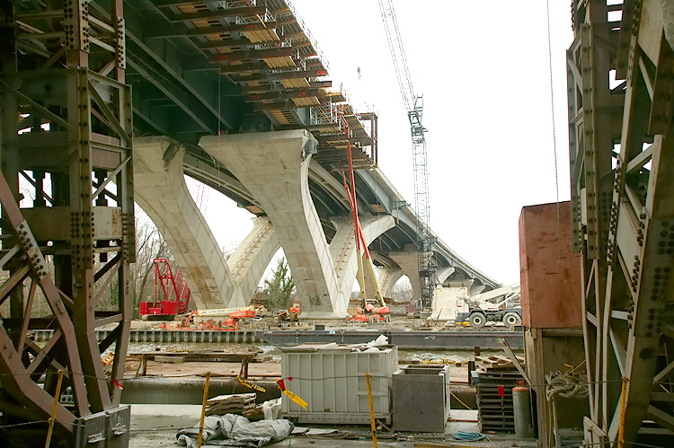
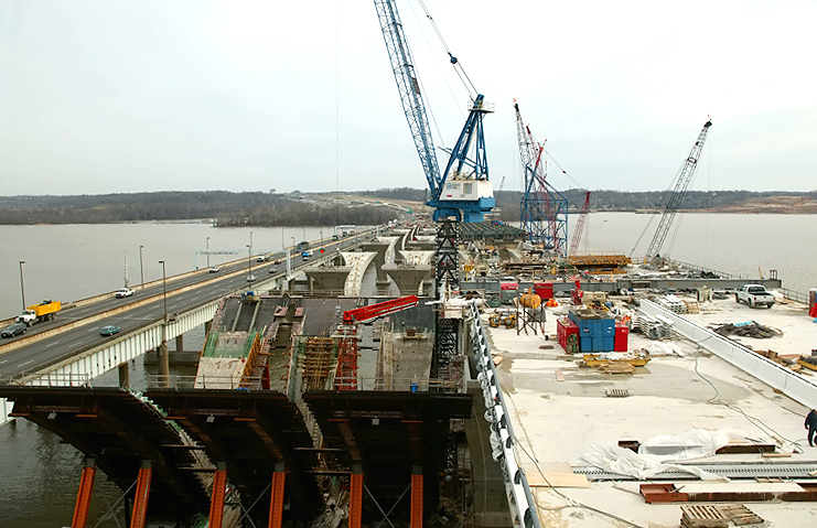
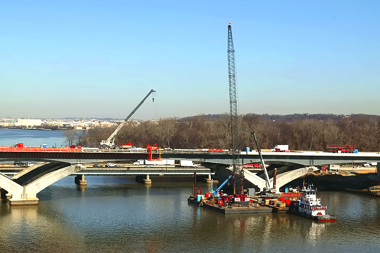
Potomac River Bridge construction, view of the Bascule Span construction, looking down on the delta piers. The delta piers for the bascule span are being constructed as cast-in-place reinforced concrete structures. |
 |
Potomac River Bridge construction, looking down on the
Bascule Span construction, and the nearly completed roadway deck on that
portion of the 6-lane Outer Loop bridge. Looking toward Virginia. I believe that this and the following set of photos that were taken from above the bridge, were taken from the under-construction new drawbridge Operator's Tower. |
 |
Potomac River Bridge construction, looking down on the Bascule Span construction, and the nearly completed roadway deck on that portion of the 6-lane Outer Loop bridge. Looking toward Maryland. The construction to the left is for the bascule span for the 6-lane Inner Loop bridge. The existing Woodrow Wilson Bridge is to the far left. |
 |
Potomac River Bridge construction, looking down on the Bascule Span construction, and the nearly completed roadway deck on that portion of the 6-lane Outer Loop bridge. Looking toward Maryland. The construction to the left is for the bascule span for the 6-lane Inner Loop bridge. |
 |
Potomac River Bridge construction, looking down on the Bascule Span and Maryland Approach Spans construction, which is being built under the Potomac River Bridge Maryland Approach Spans contract, similar vantage point to the previous photo but more telephoto. |
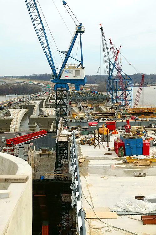 |
Potomac River Bridge construction, looking down on the Bascule Span and Maryland Approach Spans construction. I think that the "tub" to the lower left is part of the under-construction new drawbridge Operator's Tower. |
 |
Potomac River Bridge construction, looking down on the Bascule Span construction, and the nearly completed roadway deck on that portion of the 6-lane Outer Loop bridge. Looking toward Maryland with the National Harbor construction in the distance. |
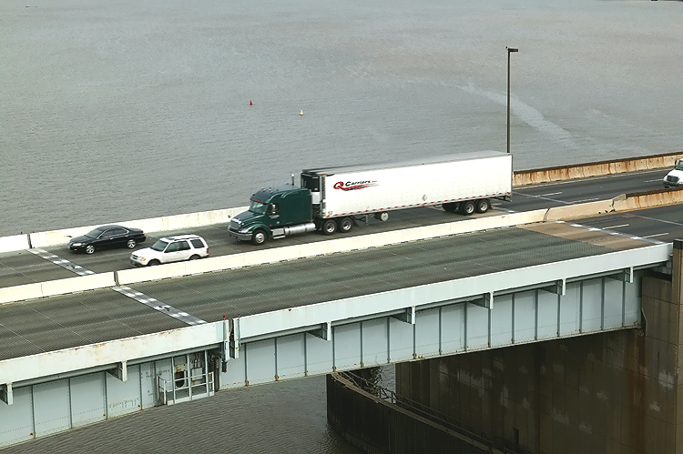 |
The existing Woodrow Wilson Bridge drawspan. The new bascule span will have 70 feet of vertical navigational clearance when the drawspan is closed, 20 feet higher than the existing bridge's bascule span which has 50 feet of vertical navigational clearance when its drawspan is closed. |
 |
Potomac River Bridge construction, looking down on the Bascule Span construction. The construction to the right is for the bascule span for the 6-lane Inner Loop bridge. The existing Woodrow Wilson Bridge and its drawspan is to the left. |
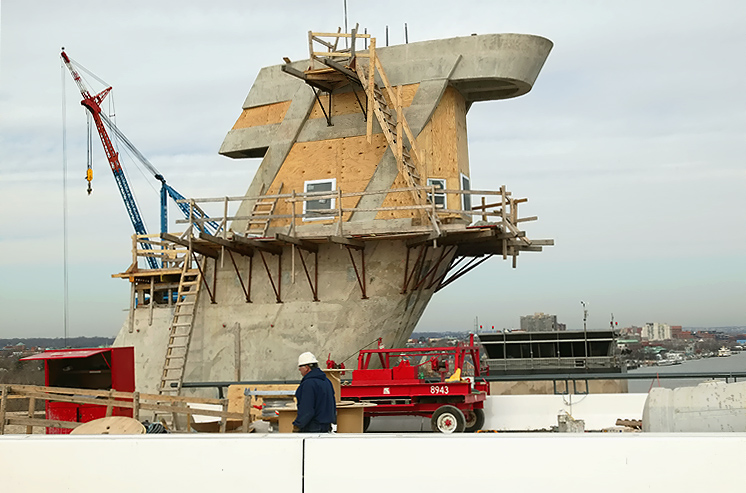 |
The under-construction new drawbridge Operator's Tower. The top of the existing bridge's operator's tower is visible in the lower right of the photo. |
 |
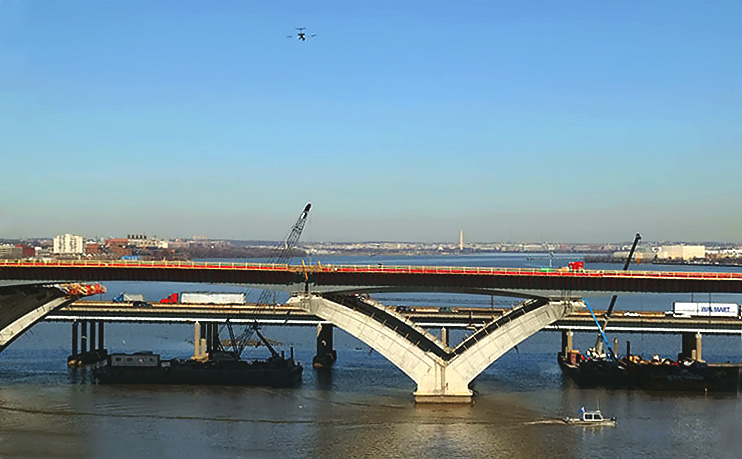
Potomac River Bridge construction, looking east from the bascule span eastern pier toward Maryland, with the Maryland Approach Spans construction visible ahead, which is being built under the Potomac River Bridge Maryland Approach Spans contract. The existing Woodrow Wilson Bridge is to the left. |
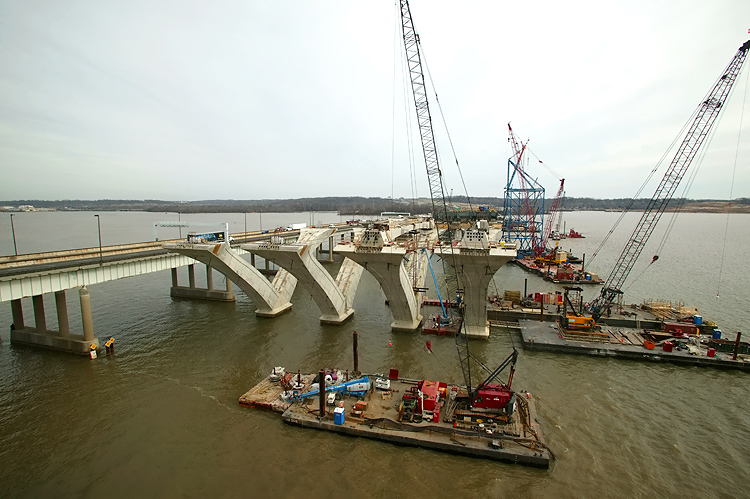 |
Potomac River Bridge construction, looking
east from the bascule span eastern
pier toward Maryland, with the Maryland
Approach Spans construction visible ahead. The existing Woodrow Wilson
Bridge is to the left. The delta piers on the approach spans are being constructed via the precast segmental method, whereby reinforced concrete segments are cast in a fabrication yard, and assembled on the pier foundations and post-tensioned with steel cables that pass through channels in the piers. The arches are held in place by temporary steel cables until the reinforced concrete cross-member links the two arches. The bridge's steel beams and roadway deck are constructed across the top of the piers. |
 |
Potomac River Bridge construction, looking east from the eastern bascule pier toward Maryland, with the Maryland Approach Spans construction visible ahead. This is a telephoto view of the top of one of the delta piers. Notice the reinforced concrete cross-member that connects the two arms of one delta pier. The holes in the concrete structure that have steel cables sticking out, are channels through the arms and cross-member for post-tensioning steel cables which will be installed and tightened with hydraulic jacks so as to effectively make the series of segments into one reinforced concrete structure. |
The following 38 photos were taken on January 28, 2006, by the Virginia Department of Transportation.
 |
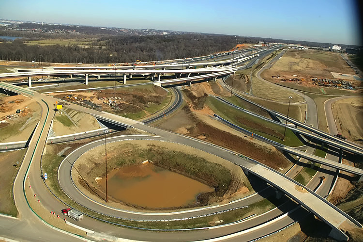
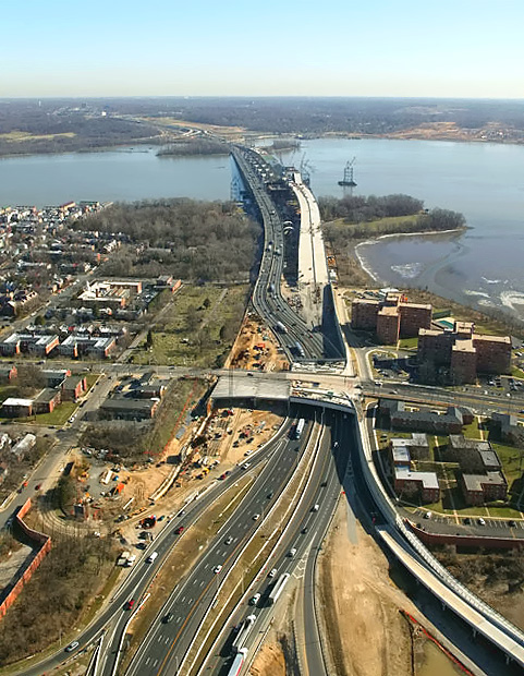
U.S. Route 1 Interchange construction, looking north
across Hunting Creek and the I-95/I-495 Capital Beltway, with Alexandria on the
north side of the Beltway. This photo was taken from over US-1, and the
new ramps can be seen on either side of US-1. The two new southerly ramps
connecting the Beltway to US-1 (Outer Loop to US-1 southbound, and US-1
northbound to Outer Loop), were opened to traffic in August and September
2005, respectively.
A new temporary ramp taking motorists from the Outer Loop of the Capital Beltway (I-95 North) to US-1 North into Old Town Alexandria opened on October 25, 2005. This temporary ramp is a temporary bridge, as it connects one bridge to another. It connects the partially-completed permanent new bridged Beltway Outer Loop local roadway, to the pre-existing US-1 bridge, with a new temporary traffic signal between the ramp and US-1. The pre-existing loop ramp for this movement was a bridge structure, and it was demolished afterward. |
 |
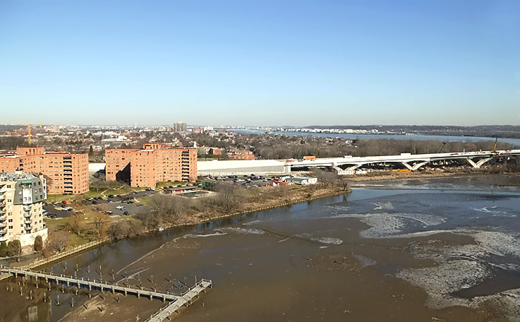
U.S. Route 1 Interchange construction, looking north across Hunting Creek, and the I-95/I-495 Capital Beltway, with Alexandria on the north side of the Beltway. The Woodrow Wilson Bridge is to the right. The new ramp from US-1 northbound to the Outer Loop of the Beltway, can be seen in the foreground of the photo, and this bridged ramp has a separate pedestrian/bicycle trail on the east side of the bridge, and the trail carries pedestrian/bicycle traffic between US-1 south of Alexandria and Washington Street and the pedestrian/bicycle trail which will cross the Potomac River on the new Woodrow Wilson Bridge to pedestrian/bicycle trails in Maryland. |
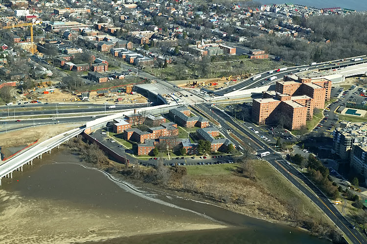 |
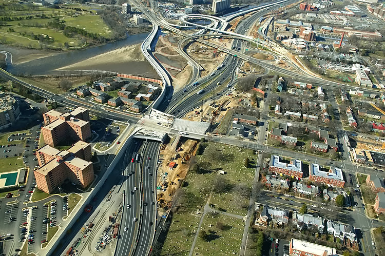
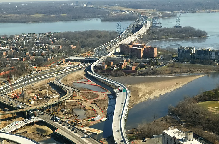
Mount Vernon Memorial Highway runs from the right bottom of the photo, upward past the apartment complex where the Mount Vernon Memorial Highway becomes Washington Street, and Washington Street crosses the Beltway and goes into Old Town Alexandria. The Beltway runs left-right across the center of the photo. |
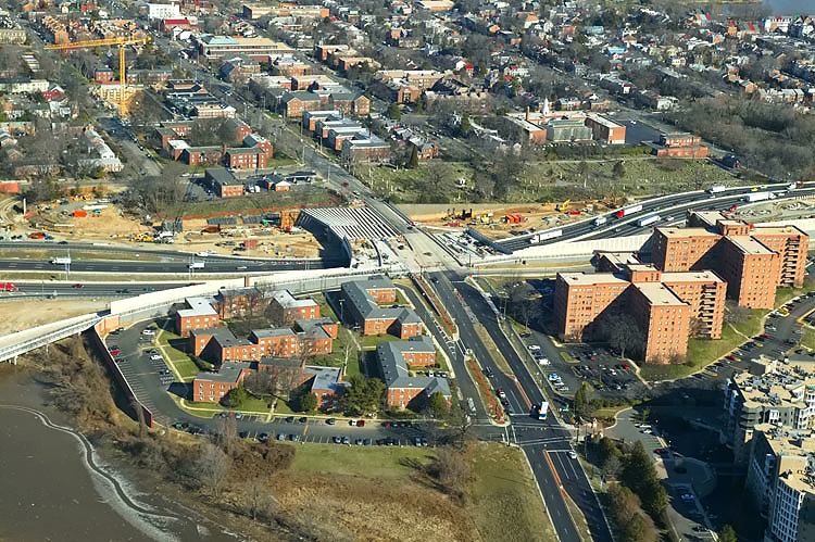 |
Mount Vernon Memorial Highway runs from the bottom of the photo, upward past the apartment complex where the Mount Vernon Memorial Highway becomes Washington Street, and Washington Street crosses the Beltway and goes into Old Town Alexandria. The Beltway runs left-right across the center of the photo. The Washington Street Urban Deck is under construction in the center of the photo. |
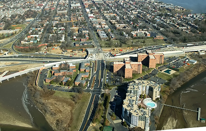 |
Mount Vernon Memorial Highway runs from the bottom of the photo, upward past the apartment complex where the Mount Vernon Memorial Highway becomes Washington Street, and Washington Street crosses the Beltway and goes into Old Town Alexandria. The Beltway runs left-right across the center of the photo. |
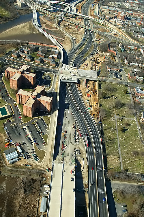 |
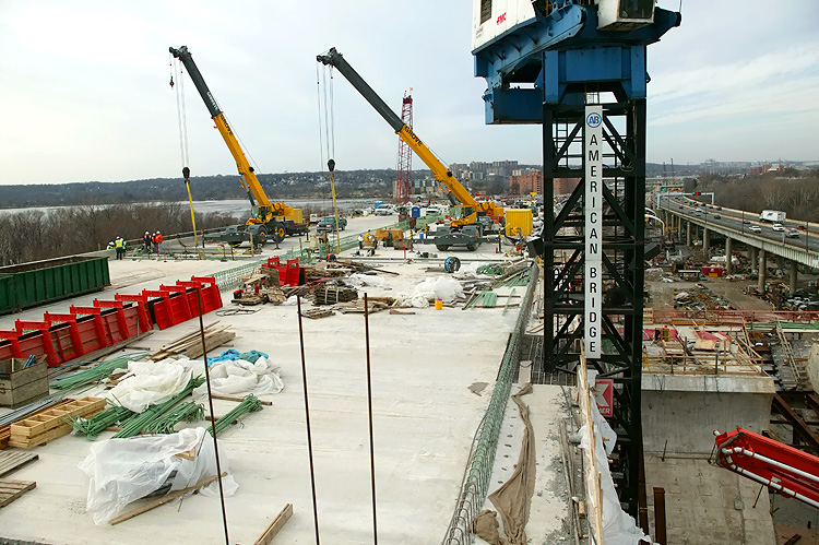
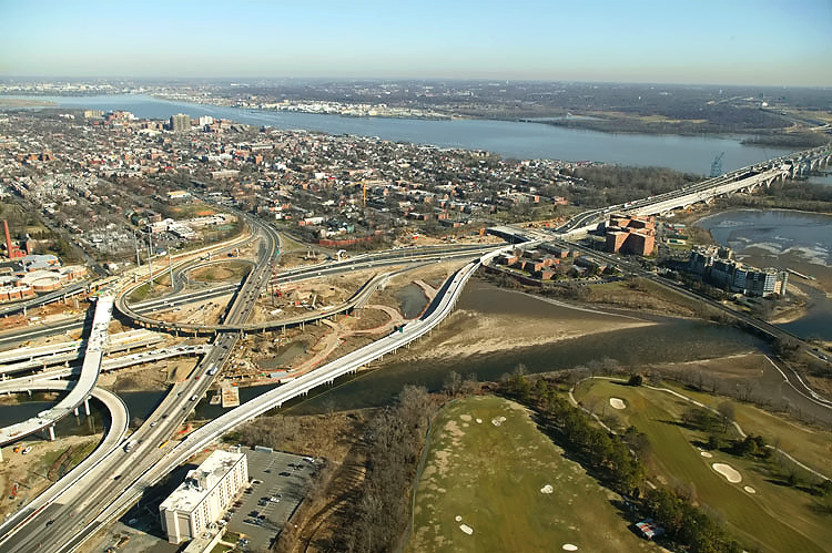
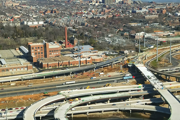
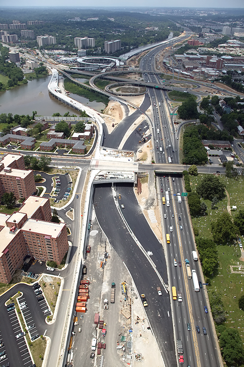
Looking west along the Beltway, showing construction of the Washington Street Urban Deck in Alexandria VA, and the U.S. Route 1 Interchange in the distance. The new highway's retaining walls close to the buildings are complete, and the Washington Street Deck has been completed over the future local and express Beltway Outer Loop roadways. The west end of the Woodrow Wilson Bridge is visible in the bottom of the photo. The Beltway detour roadway has been completed and traffic was shifted to it. Some of the Hunting Towers Apartments are visible in the left of the photo. This is what it looked like just before the tie-in construction started -- WWB-Aerial-Jun1705-1. With the Beltway traffic shifted out of the way, now construction can proceed on the northern half of the Washington Street Deck, to complete the whole deck. |
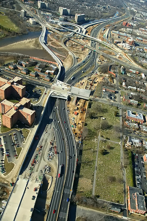 |
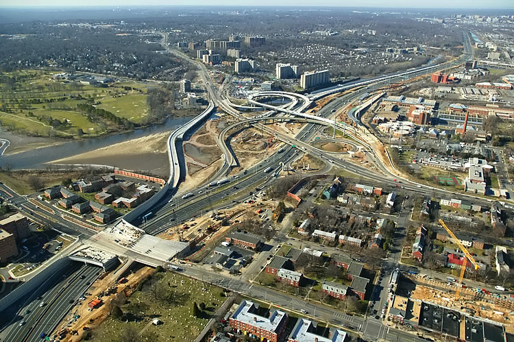
Looking west along the Beltway, showing construction of the Washington Street Urban Deck in Alexandria VA, and the U.S. Route 1 Interchange in the distance. The Washington Street Deck has been completed over the future local and express Beltway Outer Loop roadways, and the deck is under construction over the future local and express Beltway Inner Loop roadways. |
 |
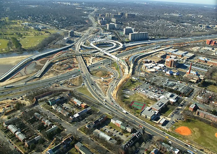
Looking west along the Beltway, showing construction of the Washington Street Urban Deck in Alexandria VA, and the U.S. Route 1 Interchange in the distance. |
 |
U.S. Route 1 Interchange construction, looking south along U.S. Route 1 which goes into the distance. |
 |
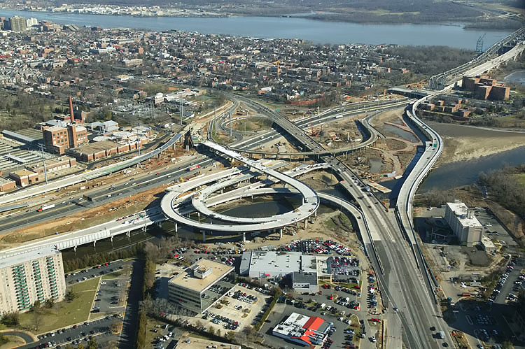
U.S. Route 1 Interchange construction, looking south along U.S. Route 1 which goes into the distance, with the Beltway running left-right. The original U.S. Route 1 Interchange had a considerable amount of bridgework across areas of water and low-lying land, with a long bridge on US-1 and bridges on four of the ramps. The original interchange opened to traffic in 1961, with a modified cloverleaf design with a semi-directional flyover ramp connecting southbound US-1 to northbound I-95/I-495 (to Wilson Bridge), and with a collector-distributor (C-D) roadway intercepting the two loop ramps on southbound I-95/I-495. |
 |
U.S. Route 1 Interchange construction, looking south across the I-95/I-495 Capital Beltway and Hunting Creek. The new ramp is nearing completion, that will replace the original semi-directional flyover ramp connecting southbound US-1 to northbound I-95/I-495 (to Wilson Bridge), and there will be a temporary tie-in between the ramp and northbound I-95/I-495. |
 |
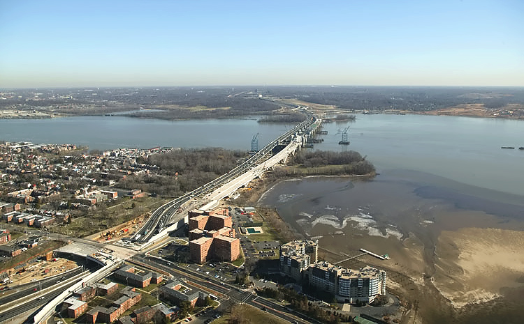
U.S. Route 1 Interchange construction, looking east across the I-95/I-495 Capital Beltway and Hunting Creek, with the Woodrow Wilson Bridge and Potomac River in the distance. The new ramp from US-1 northbound to the Outer Loop of the Beltway, can be seen in the center of the photo, and this bridged ramp has a separate pedestrian/bicycle trail on the east side of the bridge, and the trail carries pedestrian/bicycle traffic between US-1 south of Alexandria and Washington Street and the pedestrian/bicycle trail which will cross the Potomac River on the new Woodrow Wilson Bridge to pedestrian/bicycle trails in Maryland. |
 |
U.S. Route 1 Interchange construction, looking north across Hunting Creek and the I-95/I-495 Capital Beltway, with Alexandria on the north side of the Beltway. The new ramp is nearing completion, that will replace the original semi-directional flyover ramp connecting southbound US-1 to northbound I-95/I-495 (to Wilson Bridge), and there will be a temporary tie-in between the ramp and northbound I-95/I-495. |
 |
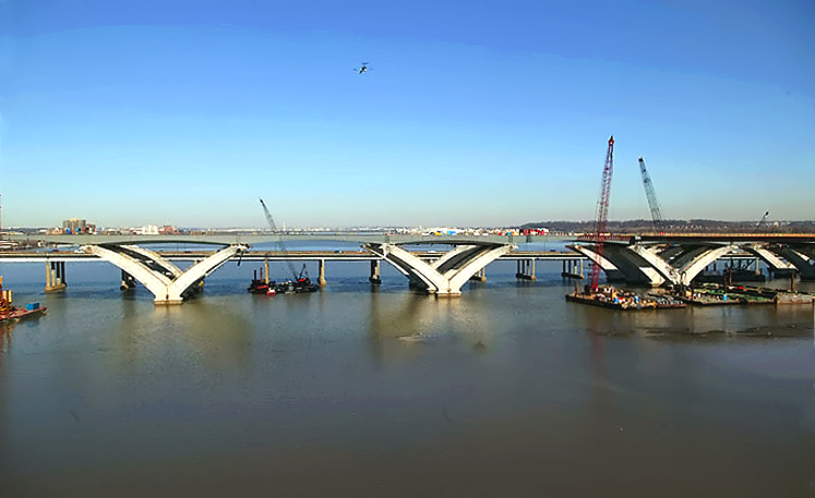
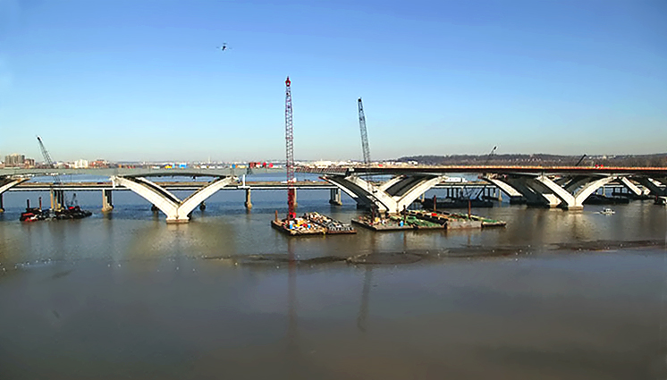
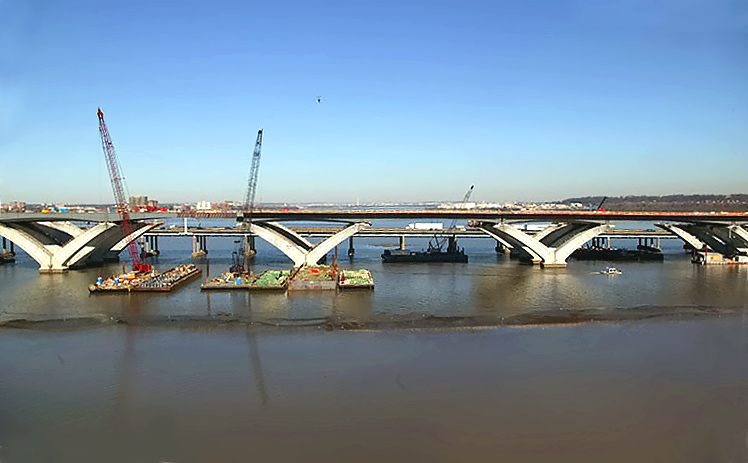
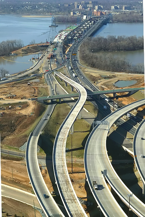
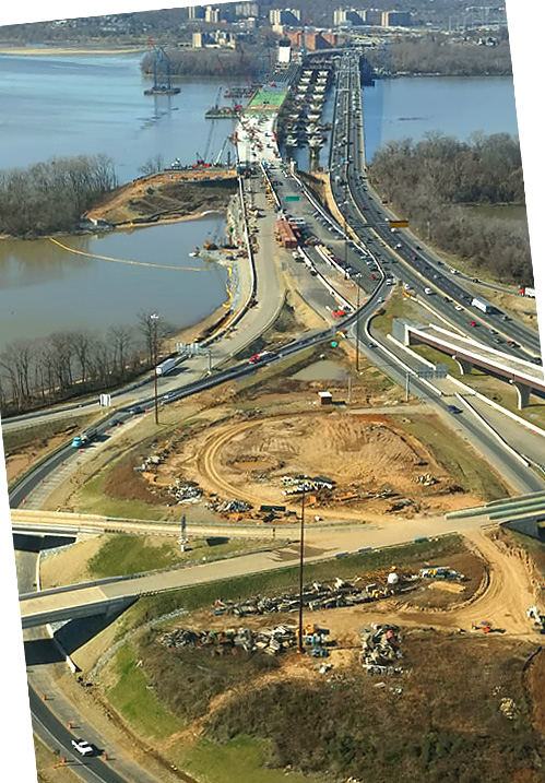
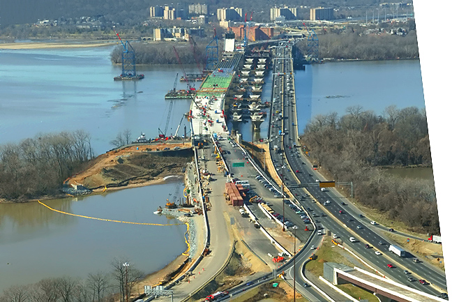
Virginia approaches construction to the Potomac River Bridge, looking north. Construction in the right of the photo is the Potomac River Bridge Virginia Approach Spans contract. The new Virginia abutment for the Potomac River Bridge is visible in the center of the photo. The Hunting Towers apartments are to the left. |
 |
Virginia approaches construction to the Potomac River Bridge, looking north. Jones Point is visible in the right of the photo. |
.jpg) |
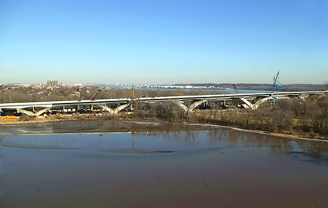
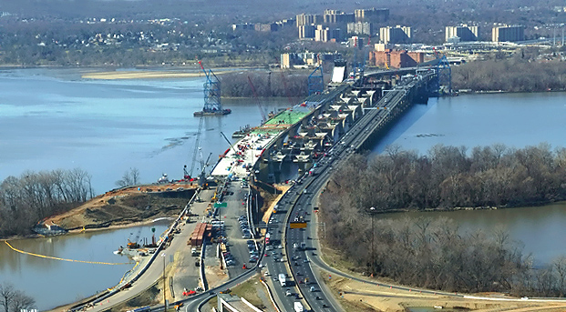
Potomac River Bridge construction, looking north. The existing Woodrow Wilson Bridge is behind the bridge under construction. |
.jpg) |
Potomac River Bridge construction, view of the Bascule Span construction, which is being built under the Potomac River Bridge Bascule Spans contract. The bascule leaves have been installed. The existing Woodrow Wilson Bridge is behind the bridge under construction. The new bascule span will have 70 feet of vertical navigational clearance when the drawspan is closed, 20 feet higher than the existing bridge's bascule span which has 50 feet of vertical navigational clearance when its drawspan is closed. Notice the raised bascule leaves on the bridge under construction. |
 |
Potomac River Bridge construction, view of the Bascule Span construction, and the Maryland Approach Spans construction, which is being built under the Potomac River Bridge Maryland Approach Spans contract. Delta pier construction is underway on the bridge foundations. The foundations were built in the Potomac River Bridge Foundations contract. |
 |
Potomac River Bridge construction, view of the Bascule Span construction, and the Maryland Approach Spans construction. |
 |
Potomac River Bridge construction, view of the Maryland Approach Spans
construction. The next 7 photos gradually pan to the Maryland shore. |
 |
Potomac River Bridge construction, view of the Maryland Approach Spans construction. |
 |
Potomac River Bridge construction, view of the Maryland Approach Spans construction. |
 |
Potomac River Bridge construction, view of the Maryland Approach Spans construction. |
 |
Potomac River Bridge construction, view of the Maryland Approach Spans
construction. Downtown Washington, D.C. is in the distance. Notice the Washington Monument visible in the right center of the photo. Notice the airliner flying overhead on its final approach to National Airport 3 miles away. |
 |
Potomac River Bridge construction, view of the Maryland Approach Spans construction. |
 |
Potomac River Bridge construction, view of the Maryland Approach Spans construction. |
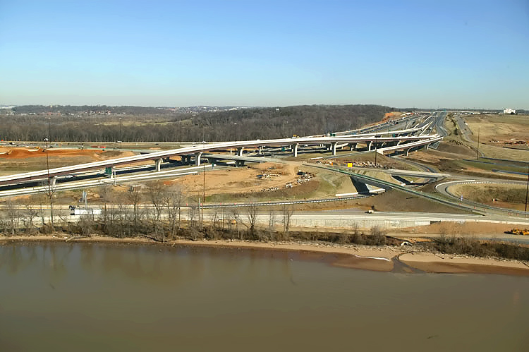 |
Interstate 295 Interchange construction, looking east, the Potomac River Bridge is just off of the left edge of the photo, and the I-95/I-495 Beltway sweeps into the distance, with I-295 to the right as it extends to MD-210 Indian Head Highway in the distance. |
 |
Interstate 295 Interchange construction, looking northeast. High capacity
roadways and ramps are being constructed to make this a 4-way interchange,
with the southerly extension heading into the National Harbor development
which began construction in 2004.
Website for National Harbor. |
 |
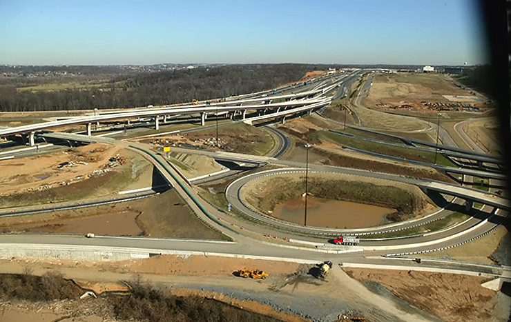
Interstate 295 Interchange construction, looking northeast. |
 |
Interstate 295 Interchange construction, looking west along the I-95/I-495 Beltway. The Woodrow Wilson Bridge across the Potomac River is in the upper center part of the photo. I-295 curves over the Beltway on the two new bridges to the right, and I-295 terminates at MD-210 Indian Head Highway about a mile to the east. The two new bridges to the left are ramps connecting the Beltway Outer Loop to I-295. |
 |
Woodrow Wilson Bridge construction, looking
west. This image is a zoom-in excerpt from the previous image. See very large image (673 kilobytes). |
 |
Interstate 295 Interchange construction, looking west along the I-95/I-495 Beltway. I-295 curves over the Beltway on the two new bridges to the center. |
 |
Interstate 295 Interchange construction, looking west along the I-95/I-495 Beltway. The Woodrow Wilson Bridge across the Potomac River is in the upper center part of the photo, with the existing WWB to the right and the under construction new WWB to the left, and Virginia is on the opposite side of the Potomac River. |
 |
Woodrow Wilson Bridge construction, looking
west. This image is a zoom-in excerpt from the previous image. See very large image (1,004 kilobytes). |
.jpg) |
Potomac River Bridge construction, looking south. The existing Woodrow Wilson Bridge is in front of the bridge under construction. Notice the raised bascule leaves on the bridge under construction. |
.jpg) |
Potomac River Bridge construction construction, looking east from Virginia into Maryland, showing construction of the Washington Street Urban Deck in Alexandria VA, and the existing (left) and under construction (right) Woodrow Wilson Bridges. |
 |
Potomac River Bridge construction construction, looking east from Virginia into Maryland, showing construction of the Washington Street Urban Deck in Alexandria VA, and the existing (left) and under construction (right) Woodrow Wilson Bridges. |
.jpg) |
Potomac River Bridge construction construction, looking east from Virginia into Maryland, showing construction of the Washington Street Urban Deck in Alexandria VA, and the existing (left) and under construction (right) Woodrow Wilson Bridges. |
 |
Potomac River Bridge construction construction, looking east from Virginia into Maryland, showing the existing (left) and under construction (right) Woodrow Wilson Bridges. |
.jpg) |
Potomac River Bridge construction construction, looking east from Virginia into Maryland, showing the existing (left) and under construction (right) Woodrow Wilson Bridges. Notice the raised bascule leaves on the bridge under construction. |
Lead article - Woodrow Wilson Bridge Project Photos
This article was released on March 1, 2006, with the 37 photos that were taken on January 9, 2006; and with 21 of the photos that were taken on January 28, 2006, 1 thru 15, 16(A), 17(B), 33(C), 34(D), 36(E), and 38(F). The 17 January 28th photos between 18 and 32 inclusive, and 35 and 37, were added on March 23, 2006.
Copyright © 2006 by Scott Kozel. All rights reserved. Reproduction, reuse, or distribution without permission is prohibited.
By Scott M. Kozel, Capital Beltway dot com, Roads to the Future
(Created 3-1-2006, updated 5-14-2006, moved to capital-beltway.com on 3-21-2007)