
| Woodrow Wilson Bridge Project Photos - December 2005 |
The following 33 photos show various aerial views of the I-95/I-495 Woodrow Wilson Bridge (WWB) Project construction, including the new Potomac River Bridge construction, the Virginia U.S. Route 1 Interchange construction, the Washington Street Urban Deck construction, and the Maryland Interstate 295 Interchange construction.
These photos were taken on December 21, 2005, by the Virginia Department of Transportation, and are posted here with their permission. Roads to the Future utilized PhotoDeluxe Business Edition to sharpen and brighten and to align all of the photos. Click on the photo to get a large version of the photo. In later versions of Netscape and Internet Explorer, you probably will need to use Full Screen mode (the F11 key can be utilized to swap back and forth between Full Screen and Regular) to see the full size of the large photo without browser-induced image shrinkage. The large photos have sizes ranging from 196 to 443 kilobytes, with most of them being under 316 kilobytes. With a broadband or network Internet connection each photo will download within seconds, but with a dial-up Internet connection it will be somewhat slower.
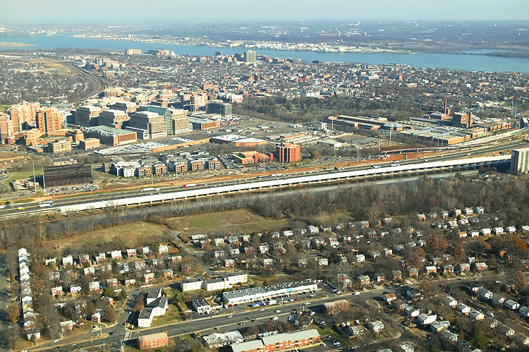 |
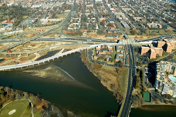
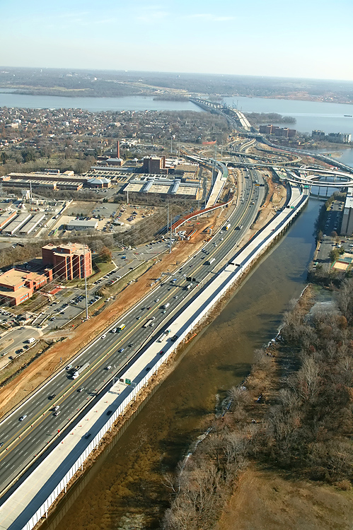
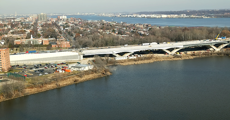
U.S. Route 1 Interchange construction, looking north across Hunting Creek (also known as Cameron Run), and the 8-lane I-95/I-495 Capital Beltway, with Alexandria on the north side of the Beltway, and the Potomac River in the distance. The long new bridge on the near side of the Beltway, is part of the completed US Route 1 Interchange Advanced Bridge contract, and the bridge will carry the Beltway Outer Loop local roadway. |
 |
U.S. Route 1 Interchange construction, looking northeast across Hunting Creek, and the I-95/I-495 Capital Beltway, with Alexandria on the north side of the Beltway. The Woodrow Wilson Bridge and Potomac River is in the distance. The $147 million US Route 1 Interchange (Major Portion) contract is 25% complete as of December 2005. |
 |
U.S. Route 1 Interchange construction, looking northeast across Hunting Creek, and the I-95/I-495 Capital Beltway, with Alexandria on the north side of the Beltway. The Woodrow Wilson Bridge and Potomac River is in the distance. |
.jpg) |
U.S. Route
1 Interchange construction, looking north across Hunting Creek and the I-95/I-495
Capital Beltway, with Alexandria on the north side of the Beltway. This photo
was taken from over US-1, and the new ramps can be seen on either side of
US-1. The two new southerly ramps connecting the Beltway to US-1 (Outer Loop
to US-1 southbound, and US-1 northbound to Outer Loop), were opened to traffic
in August and September 2005, respectively.
A new temporary ramp taking motorists from the Outer Loop of the Capital Beltway (I-95 North) to US-1 North into Old Town Alexandria opened on October 25, 2005. This temporary ramp is a temporary bridge, as it connects one bridge to another. It connects the partially-completed permanent new bridged Beltway Outer Loop local roadway, to the pre-existing US-1 bridge, with a new temporary traffic signal between the ramp and US-1. The pre-existing loop ramp for this movement was a bridge structure, and it was demolished afterward. |
 |
U.S. Route 1 Interchange construction, looking north across Hunting Creek, and the I-95/I-495 Capital Beltway, with Alexandria on the north side of the Beltway. The new ramps can be seen on either side of US-1. The two new southerly ramps connecting the Beltway to US-1 (Outer Loop to US-1 southbound, and US-1 northbound to Outer Loop), were opened to traffic in August and September 2005, respectively. |
 |
U.S. Route 1 Interchange construction, looking north across Hunting Creek, and the I-95/I-495 Capital Beltway, with Alexandria on the north side of the Beltway. The new ramp from US-1 northbound to the Outer Loop of the Beltway, can be seen in the foreground of the photo, and this bridged ramp has a separate pedestrian/bicycle trail on the east side of the bridge, and the trail carries pedestrian/bicycle traffic between US-1 south of Alexandria and Washington Street and the pedestrian/bicycle trail which will cross the Potomac River on the new Woodrow Wilson Bridge to pedestrian/bicycle trails in Maryland. |
 |
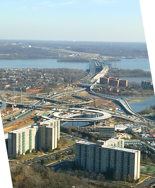
Mount Vernon Memorial Highway runs from the bottom of the photo, upward past the apartment complex where the Mount Vernon Memorial Highway becomes Washington Street, and Washington Street crosses the Beltway and goes into Old Town Alexandria. The Beltway runs left-right across the center of the photo. |
 |
Mount Vernon Memorial Highway runs from the bottom of the photo, upward past the apartment complex where the Mount Vernon Memorial Highway becomes Washington Street, and Washington Street crosses the Beltway and goes into Old Town Alexandria. The Beltway runs left-right across the center of the photo. |
.jpg) |
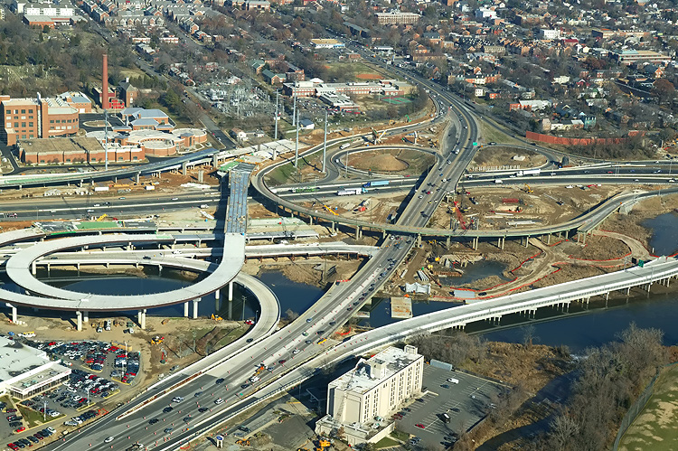
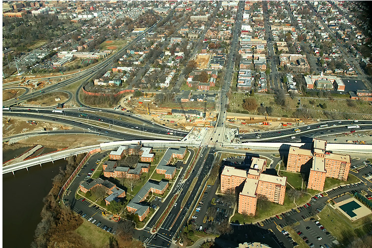
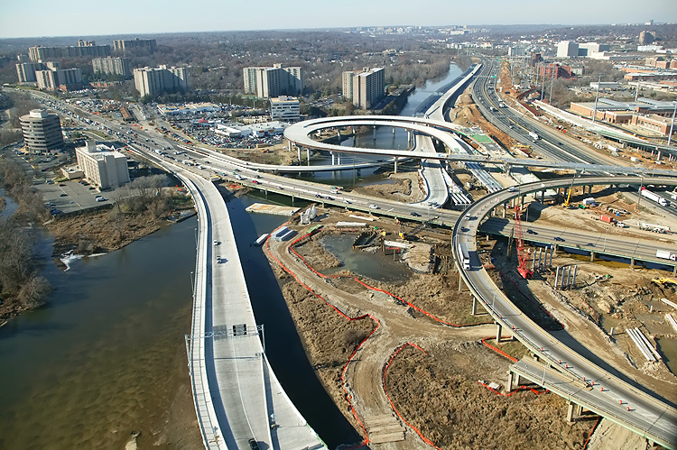
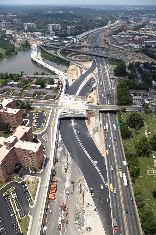
Looking west along the Beltway, showing construction of the Washington Street Urban Deck in Alexandria VA, and the U.S. Route 1 Interchange. |
 |
Looking
west along the Beltway, showing construction of the Washington Street Urban
Deck in Alexandria VA, and the U.S. Route 1 Interchange. The new elevated ramps along the left (south) side of the Beltway, are elements of the US Route 1 Interchange Advanced Bridge contract, which was started in June 2003 and completed in September 2005 at a cost of $38 million. The two new southerly ramps connecting the Beltway to US-1 (Outer Loop to US-1 southbound, and US-1 northbound to Outer Loop), were opened to traffic in August and September 2005, respectively. |
.jpg) |
Looking west along the Beltway, showing construction of the Washington Street Urban Deck in Alexandria VA, and the U.S. Route 1 Interchange in the distance. The new highway's retaining walls close to the buildings are complete, and the Washington Street Deck has been completed over the future local and express Beltway Outer Loop roadways. The Beltway detour roadway has been completed and traffic was shifted to it. Some of the Hunting Towers Apartments are visible in the lower left of the photo. The US-1 interchange is visible in the distance. This is what it looked like just before the tie-in construction started -- WWB-Aerial-Jun1705-1. With the Beltway traffic shifted out of the way, now construction can proceed on the northern half of the Washington Street Deck, to complete the whole deck. |
 |
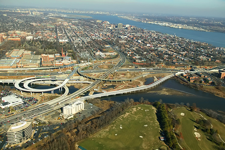
U.S. Route 1 Interchange construction, looking south along U.S. Route 1 which goes into the distance. |
.jpg) |
U.S. Route 1 Interchange construction, looking south along U.S. Route 1 which goes into the distance, with the Beltway running left-right. The original U.S. Route 1 Interchange had a considerable amount of bridgework across areas of water and low-lying land, with a long bridge on US-1 and bridges on four of the ramps. The original interchange opened to traffic in 1961, with a modified cloverleaf design with a semi-directional flyover ramp connecting southbound US-1 to northbound I-95/I-495 (to Wilson Bridge), and with a collector-distributor (C-D) roadway intercepting the two loop ramps on southbound I-95/I-495. |
.jpg) |
U.S. Route 1 Interchange construction, looking south across the I-95/I-495 Capital Beltway and Hunting Creek. The new ramp is nearing completion, that will replace the original semi-directional flyover ramp connecting southbound US-1 to northbound I-95/I-495 (to Wilson Bridge), and there will be a temporary tie-in between the ramp and northbound I-95/I-495. |
 |
U.S. Route 1 Interchange construction, looking south across the I-95/I-495 Capital Beltway and Hunting Creek. |
 |
Looking east along the Beltway, showing construction of the U.S. Route 1 Interchange. The new elevated roadway along the right (south) side of the Beltway, are elements of the US Route 1 Interchange Advanced Bridge contract, the Outer Loop local roadway. |
 |
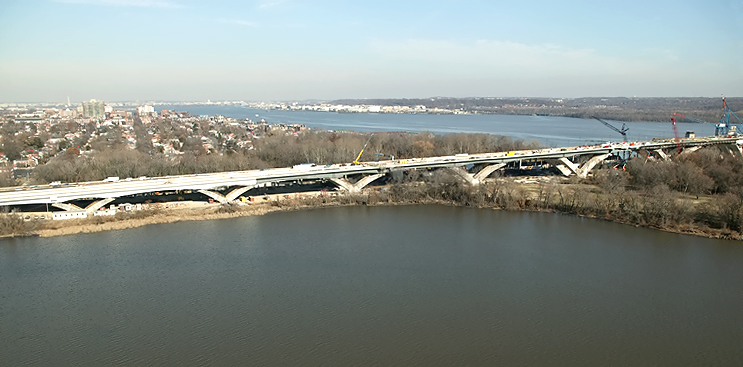
U.S. Route 1 Interchange construction, looking east across Hunting Creek, and the 8-lane I-95/I-495 Capital Beltway, with Alexandria on the north side of the Beltway, and the Potomac River and Woodrow Wilson Bridge is visible in the distance. |
 |
U.S. Route 1 Interchange construction, looking north across Hunting Creek, and the I-95/I-495 Capital Beltway, with Alexandria on the north side of the Beltway. The new ramp from US-1 northbound to the Outer Loop of the Beltway (to Wilson Bridge), can be seen in the foreground of the photo, and this bridged ramp has a separate pedestrian/bicycle trail on the east side of the bridge, and the trail carries pedestrian/bicycle traffic between US-1 south of Alexandria and Washington Street and the pedestrian/bicycle trail which will cross the Potomac River on the new Woodrow Wilson Bridge to pedestrian/bicycle trails in Maryland. |
 |
Looking west along the Beltway, showing construction of the U.S. Route 1 Interchange. The new elevated ramps along the left (south) side of the Beltway, are elements of the US Route 1 Interchange Advanced Bridge contract. The two new southerly ramps connecting the Beltway to US-1 (Outer Loop to US-1 southbound, and US-1 northbound to Outer Loop), were opened to traffic in August and September 2005, respectively. The ramp in the left foreground is the ramp with the separate pedestrian/bicycle trail described in the previous photo. |
 |
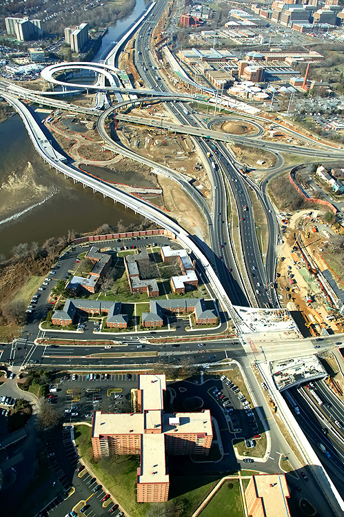
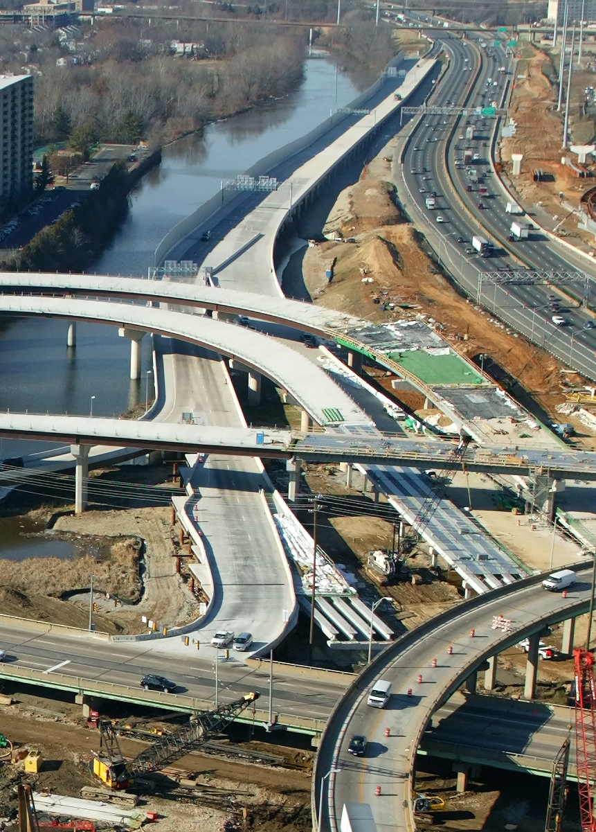
This is
a zoom-in excerpt from the previous photo, to show the entire mile-long new
bridge for the Beltway Outer Loop local roadway, and its temporary bridge
connection to the US-1 bridge which is visible at the bottom of the photo.
The entire bridge is utilized for the exits from the Beltway Outer Loop to
both directions of US-1. Large image (size 751 kilobytes) A new temporary ramp taking motorists from the Outer Loop of the Capital Beltway (I-95 North) to US-1 North into Old Town Alexandria opened on October 25, 2005. This temporary ramp is a temporary bridge, as it connects one bridge to another. It connects the partially-completed permanent new bridged Beltway Outer Loop local roadway, to the pre-existing US-1 bridge, with a new temporary traffic signal between the ramp and US-1. The pre-existing loop ramp for this movement was a bridge structure, and it was demolished afterward. |
 |
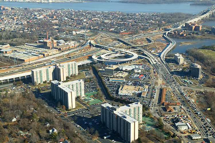
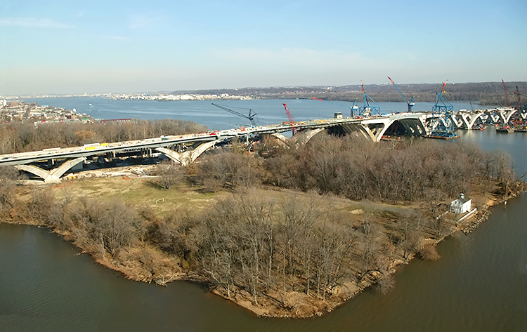
Virginia approaches construction to the Potomac River Bridge, looking north. Construction in the right of the photo is the Potomac River Bridge Virginia Approach Spans contract. The new Virginia abutment for the Potomac River Bridge is visible in the center of the photo. |
 |
Virginia approaches construction to the Potomac River Bridge, looking north. The existing Woodrow Wilson Bridge and Old Town Alexandria and the Potomac River are visible in the upper part of the photo. The new Virginia abutment for the Potomac River Bridge is visible in the left of the photo. |
 |
Virginia approaches construction to the Potomac River Bridge, looking north. Jones Point is visible in the right of the photo. |
 |
Potomac River Bridge construction, looking north, across Jones Point, at the Virginia Approach construction, and the Bascule Span construction. The new 12-lane twin-span bridge is being built just to the south of the existing 6-lane bridge. |
.jpg) |
Potomac River Bridge construction, looking north, across Jones Point, at the Virginia Approach construction, and the Bascule Span construction. The Potomac River and downtown Washington, D.C. is in the distance. |
.jpg) |
Potomac River Bridge construction, view of the Bascule Span construction, which is being built under the Potomac River Bridge Bascule Spans contract. The existing WWB is behind the bridge under construction. |
 |
Interstate 295 Interchange construction, looking east, the south section of the interchange that heads into the property of the National Harbor development. Website for National Harbor. |
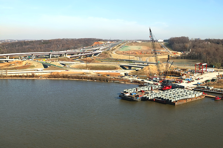 |
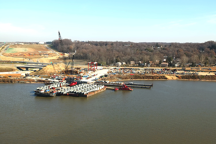
Interstate 295 Interchange construction, looking east, the south section of the interchange that heads into the property of the National Harbor development. The center part of the photo shows the fabrication yard for the pre-casting of the segments that are being utilized for the piers on the Potomac River Bridge Maryland Approach Spans construction. This fabrication yard is visible in the previous photo, and both photos show the Potomac River docks for barges that transport materials to the WWB Project. Notice the docked barge carrying the load of steel bridge girders to the project site. |
 |
Potomac River Bridge construction,
looking south, view of the Maryland Approach Spans construction, which is
being built under the Potomac River Bridge Maryland Approach Spans
contract. The delta piers on the approach spans are being constructed via the precast segmental method, whereby reinforced concrete segments are fabricated in a fabrication yard, and assembled on the pier foundations and post-tensioned with steel cables that pass through channels in the piers. The arches are held in place by temporary steel cables until the reinforced concrete cross-member links the two arches. The bridge's steel beams and roadway deck will be constructed across the top of the piers. |
 |
Potomac River Bridge construction, view of the Bascule Span construction, which is being built under the Potomac River Bridge Bascule Spans contract. |
 |
Construction in the center of the photo is the Potomac River Bridge Virginia Approach Spans contract. The existing Woodrow Wilson Bridge is on the near side of the construction. Jones Point is visible in the upper center of the photo. The Potomac River heads to the south in the distance. |
.jpg) |
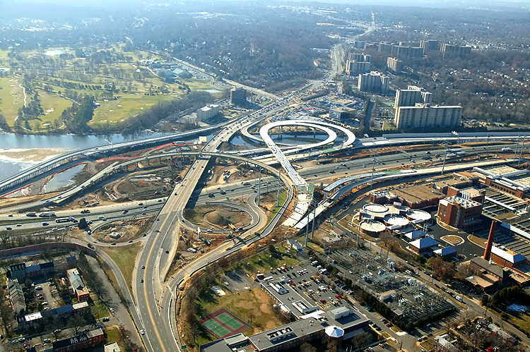
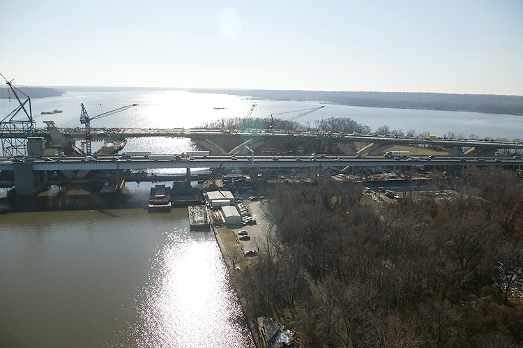
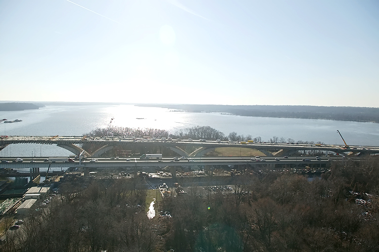
Potomac River Bridge construction, looking east from Virginia into Maryland. The new 6-lane Outer Loop bridge is to the right, and the piers, girders and roadway deck have been constructed on this section. The existing 6-lane WWB is to the left. |
.jpg) |
Potomac River Bridge construction, looking east. The new 6-lane Outer Loop bridge is to the right, and the piers, girders and roadway deck have been constructed on this section. The 12-lane bascule span is under construction, and the new bridge will have 12 lanes. The existing 6-lane WWB is to the left. |
Lead article - Woodrow Wilson Bridge Project Photos
This article was released on January 1, 2006, with the 9 photos, 04(A), 09(B), 11(C), 13(D), 14(E), 24(F), 25(G), 31(H), and 32(I). The 19 photos between 1 and 25 inclusive were added on January 16, 2006. The 5 photos between 26 and 30 inclusive were added on February 11, 2006.
Copyright © 2006 by Scott Kozel. All rights reserved. Reproduction, reuse, or distribution without permission is prohibited.
By Scott M. Kozel, Capital Beltway dot com, Roads to the Future
(Created 1-1-2006, updated 2-11-2006, moved to capital-beltway.com on 3-18-2007)