
| Woodrow Wilson Bridge Project Photos - April 2008 |
This article has a group of 45 aerial photos taken on April 17, 2008, and a group of 32 ground-level photos taken on April 18, 2008. The group of 45 photos taken on April 17, 2008, were added to this article on October 10, 2008. The group of 32 photos taken on April 18, 2008, were in the original release of article.
The following 45 photos show various aerial views of the I-95/I-495 Woodrow Wilson Bridge (WWB) Project construction, including the new Potomac River Bridge construction, the Virginia Eisenhower Avenue Connector interchange, the Virginia VA-241 Telegraph Road Interchange construction, Virginia U.S. Route 1 Interchange construction, the Washington Street Urban Deck construction, the Maryland Interstate 295 Interchange construction, and the Maryland MD-210 Indian Head Highway Interchange construction.
These photos were taken on April 17, 2008 by the Virginia Department of Transportation, and are posted here with their permission. Roads to the Future utilized PhotoDeluxe Business Edition to sharpen and brighten and to align all of the photos. Click on the photo to get a large version of the photo. In later versions of Netscape and Internet Explorer, you probably will need to use Full Screen mode (the F11 key can be utilized to swap back and forth between Full Screen and Regular) to see the full size of the large photo without browser-induced image shrinkage. The large photos have sizes ranging from 162 to 390 kilobytes, with most of them being under 297 kilobytes. The photos marked "LARGE PHOTO" are much larger, with a very detailed zoom-in of the previous photo, and they have the file size listed next to the photo. With a broadband or network Internet connection each photo will download within seconds, but with a dial-up Internet connection it will be somewhat slower.
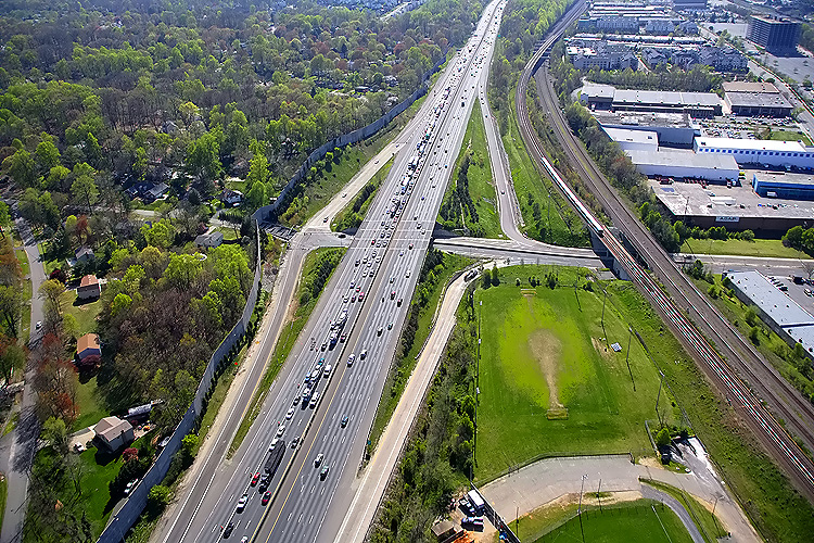 |
The I-95/I-495
Capital Beltway and Eisenhower Avenue Connector interchange, Virginia Exit
174, looking west along the Beltway toward Springfield. The 4-lane Eisenhower
Avenue parallels the Beltway for several miles, about 1/2 mile to the north,
and except for the top right of the photo is mostly beyond the right edge
of the photo.
The VA-241 Telegraph Road interchange and that segment of the Beltway, is being rebuilt and expanded as part of the WWB Project, and that segment began construction in early 2008, and will extend the Beltway widening westward to the Eisenhower Avenue Connector interchange, with the 4 lane each way Beltway widening to 5 lanes each way east of this interchange, expanding to 6 lanes each way about 1/2 mile to the east of there. The railroads to the right of the Beltway, are, to the left, the WMATA Metro rapid rail transit line Franconia-Springfield Route (Blue Line trains), and, to the right, the mainline of the CSXT Railroad and the Norfolk Southern Railroad. Notice the Metro train in the middle of the photo. Notice that the WMATA railroad passes over the mainline railroad near the top of the photo. |
 |
The I-95/I-495 Capital Beltway and Eisenhower Avenue Connector interchange, looking east along the Beltway toward the WWB and Maryland. The railroads mentioned in the previous photo description, are to the left. |
 |
The I-95/I-495
Capital Beltway and Eisenhower Avenue Connector interchange, similar vantage
point as previous photo, closer view.
This interchange was not part of the original Beltway, it was opened to traffic in August 1997 along with the 4-lane Eisenhower Avenue Connector that connects to Eisenhower Avenue. The Beltway underpass that the Eisenhower Avenue Connector utilized, was part of the original Beltway, and it carried the 2-lane Clermont Drive which had a one-lane underpass under the mainline railroad. The agreement to build the new interchange included the cul-de-sacing of Clermont Drive so that Beltway traffic would not have access to the Clermont neighborhood (this is what that neighborhood requested), and the sound barrier to the right provides that barrier, but has provision for pedestrians to pass through between the Clermont neighborhood and the Eisenhower Avenue Connector. |
 |
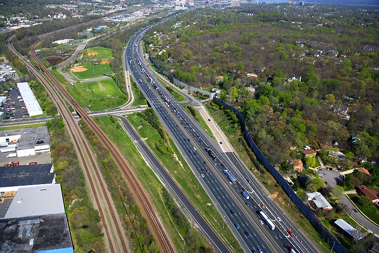
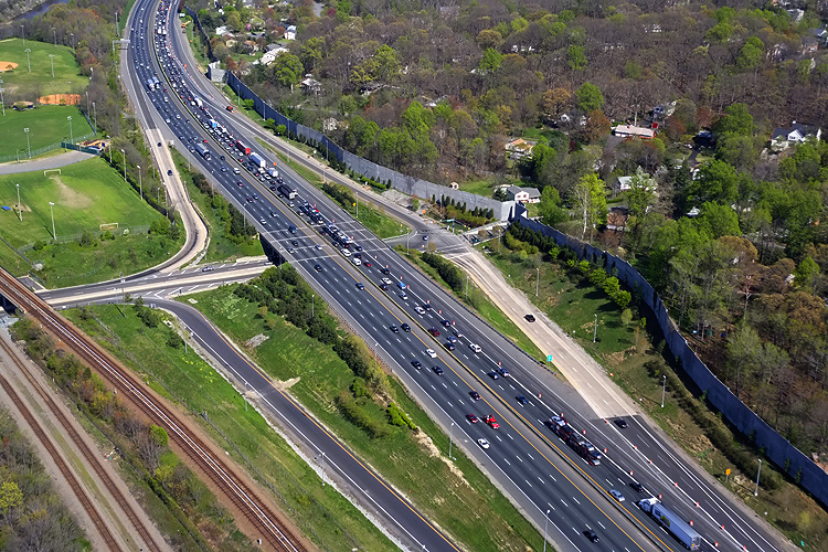
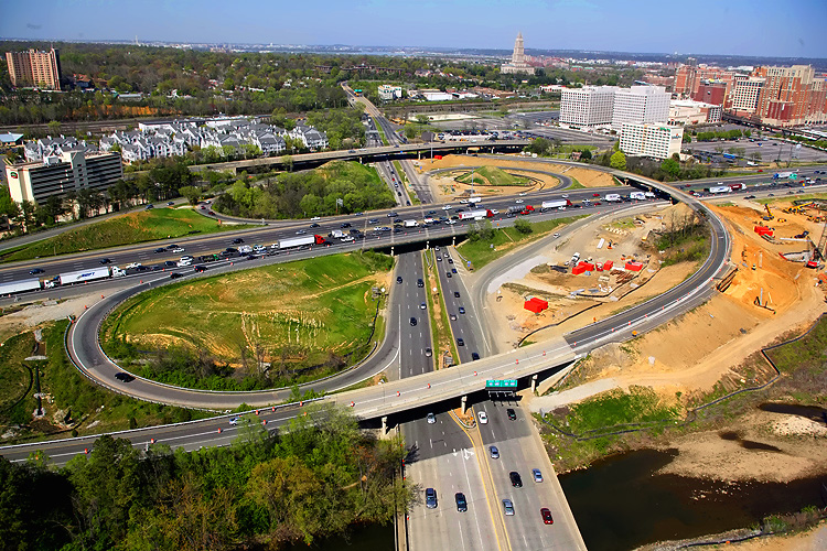
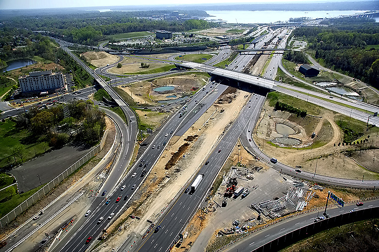
The I-95/I-495
Capital Beltway and VA-241 Telegraph Road Interchange (Virginia Exit 176),
looking east along the Beltway toward the WWB and Maryland.
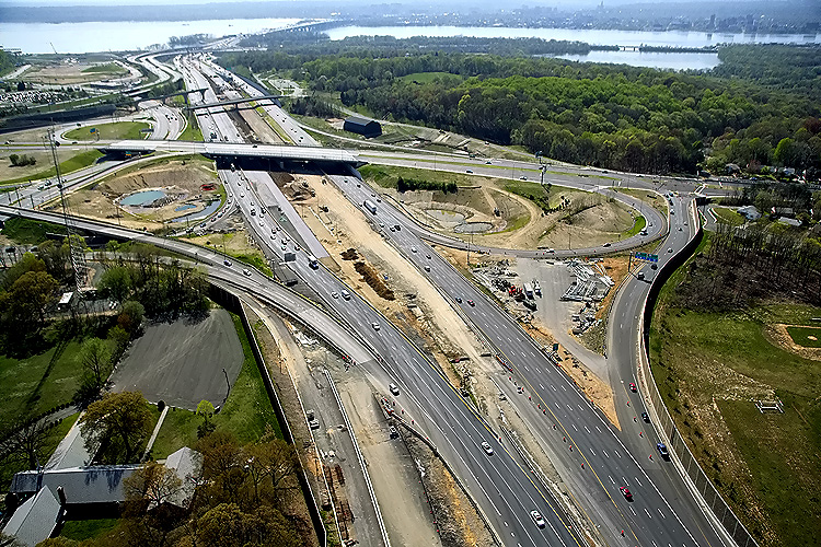
This segment of the Beltway will be reconstructed in the Telegraph Road segment of the Woodrow Wilson Bridge Project, a $236 million contract which just began construction, and this contract includes raising the Beltway roadways to provide 5 feet more elevation over Cameron Run to provide a higher resistance to flooding in heavy rainstorm conditions. Per the VDOT Dashboard entry for the project on March 16, 2008, the Contract Award was $236,393,188, the Contract Execution Date was February 12, 2008, and the Original Specified Completion Date is June 30, 2013. The Contract Execution Date includes the Notice to Proceed for the contractor. The construction contractor is CK Constructors, a joint venture of Corman Construction, Inc., and Kiewit Corporation. The contract to rebuild the I-95/I-495 interchange at Telegraph Road, and the remainder of the Beltway between the US-1 Interchange project segment and the Eisenhower Avenue Connector interchange (Virginia Exit 174), will take 5 years to complete. The contract includes 11 ramps and bridges, 5 box culvert extensions, drainage improvements, retaining walls, overhead signs, noise walls, pedestrian paths, landscaping, and environmental mitigation. |
 |
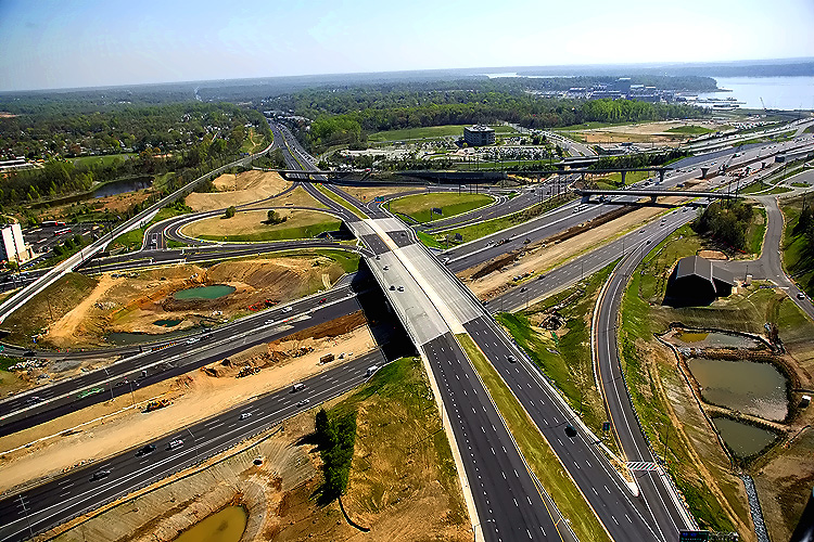
The I-95/I-495
Capital Beltway and Telegraph Road Interchange, looking north along Telegraph
Road toward Alexandria. Telegraph Road is a 4- to 6-lane arterial, and the
Beltway interchange is in the center of the photo.
The 8-lane I-95/I-495 Capital Beltway runs left to right, Hunting Creek (also known as Cameron Run) is just below the Beltway. The VA-241 Telegraph Road Interchange of the Beltway was originally built in 1961 as a modified cloverleaf interchange with one semi-directional ramp. The road paralleling just above the Beltway is the 4-lane Eisenhower Avenue, and it has a long bridge over Telegraph Road. Telegraph Road runs bottom to top, and its junctions from bottom to top in order are, the interchange with the Beltway, an interchange with local roads in the Eisenhower Valley, and the northern terminus of Telegraph Road which has a trumpet interchange with VA-236 Duke Street in Alexandria. The mainline of the CSXT Railroad and the Norfolk Southern Railroad parallels between Eisenhower Avenue and VA-236 Duke Street. Telegraph Road mainline bridges in this photo are, over Hunting Creek, over the mainline railroads, and over Duke Street. |
 |
The I-95/I-495 Capital Beltway and VA-241 Telegraph Road Interchange, looking northwest. |
 |
The I-95/I-495 Capital Beltway and VA-241 Telegraph Road Interchange, looking west along the Beltway toward Springfield. |
 |
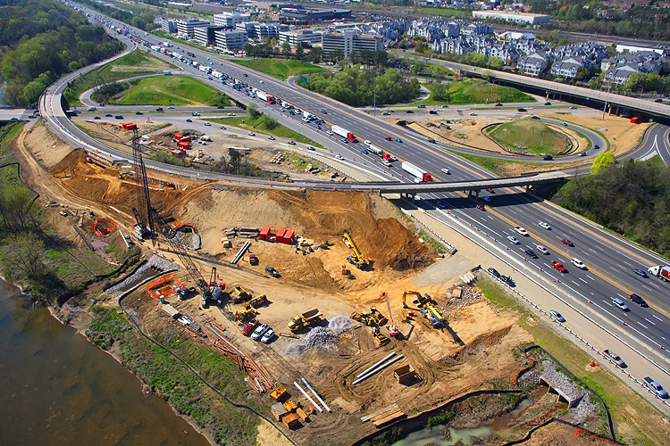
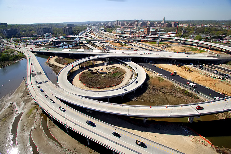
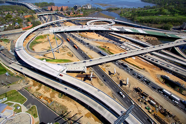
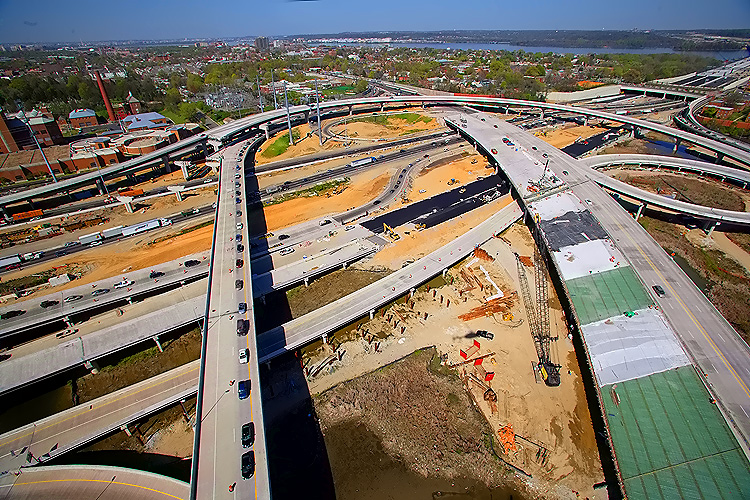
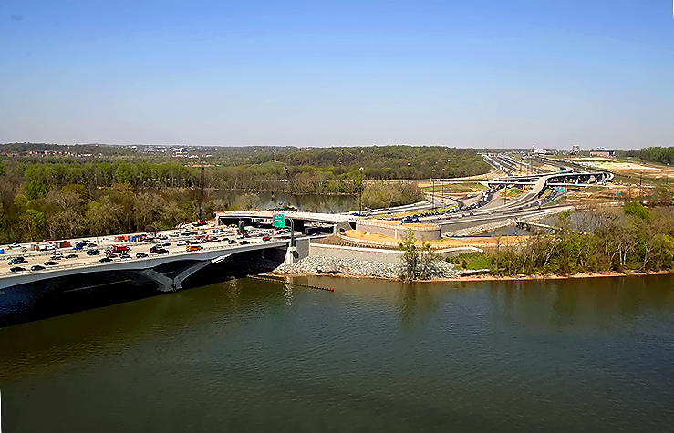
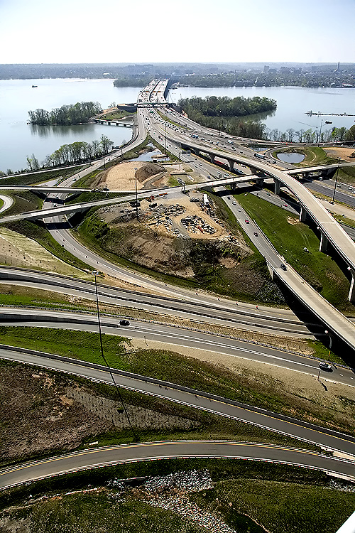
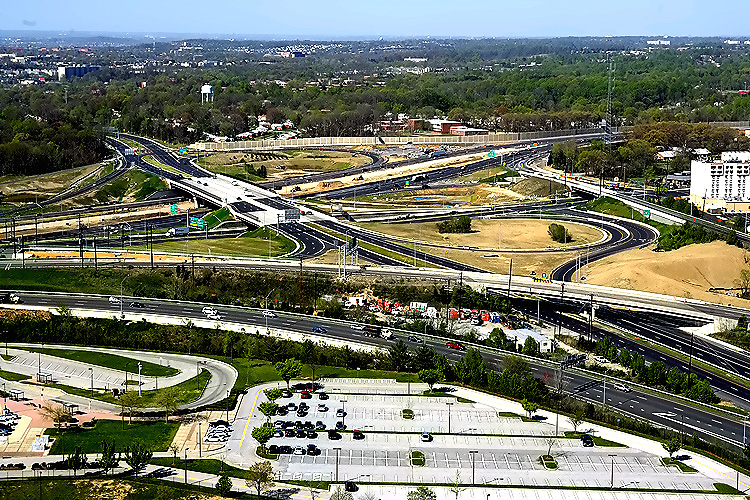
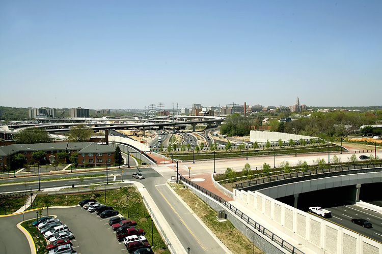
The I-95/I-495 Capital Beltway runs left to right, this is part of the U.S. Route 1 Interchange construction in Virginia. Notice the elevated ramps under construction in the center of the photo, they are part of the local ramps that will connect the Eisenhower Valley in Alexandria, Virginia, to the Beltway's traffic to and from Maryland. The long new bridge on the near side of the Beltway, will carry the Beltway Outer Loop local roadway; as of this photo shot it is carrying local traffic exiting the Beltway to US-1. |
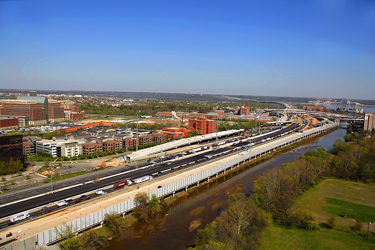 |
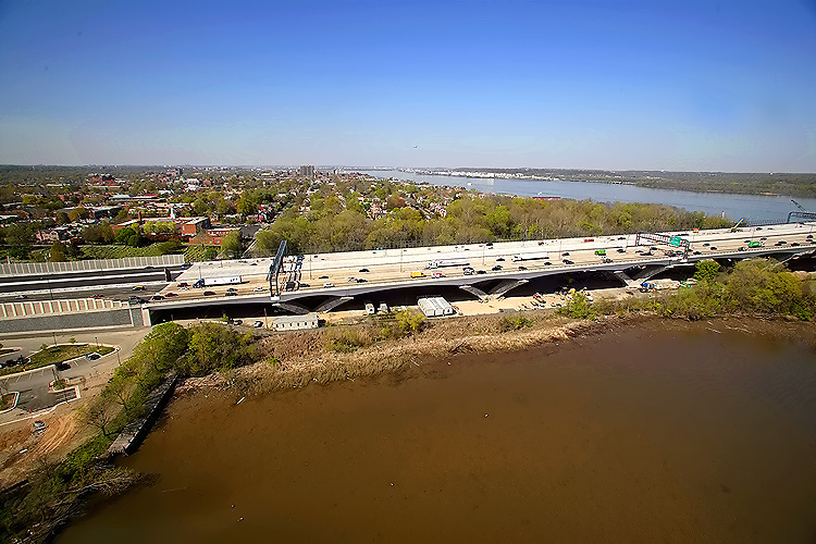
The I-95/I-495 Capital Beltway runs lower left to upper right, Cameron Run is just to the right of the Beltway, the Potomac River is in the upper part of the photo, the U.S. Route 1 Interchange (Virginia Exit 177) construction is in the right of the photo, and the Woodrow Wilson Bridge is in the right of the photo. Alexandria, Virginia is on the north side of (above) the Beltway. Virginia is on this side of the Potomac River, and Maryland and Washington, D.C. is on the opposite side of the river. |
 |
The I-95/I-495 Capital Beltway runs lower left to upper right, Cameron Run is just to the right of the Beltway, the Potomac River is in the upper part of the photo, the U.S. Route 1 Interchange construction is in the right of the photo, and the Woodrow Wilson Bridge is in the right of the photo. |
 |
The I-95/I-495 Capital Beltway runs lower left to upper right, Hunting Creek is just to the right of the Beltway, the Potomac River is in the upper part of the photo, the U.S. Route 1 Interchange construction is in the center of the photo, and the Woodrow Wilson Bridge is in the upper right of the photo. Virginia is on this side of the Potomac River, and Maryland is on the opposite side. |
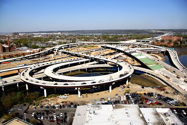 |
The I-95/I-495 Capital Beltway runs lower left to upper right, Hunting Creek is just to the right of the Beltway, the Potomac River is in the upper part of the photo, the U.S. Route 1 Interchange construction is in the center of the photo, and the Woodrow Wilson Bridge is in the upper right of the photo. |
 |
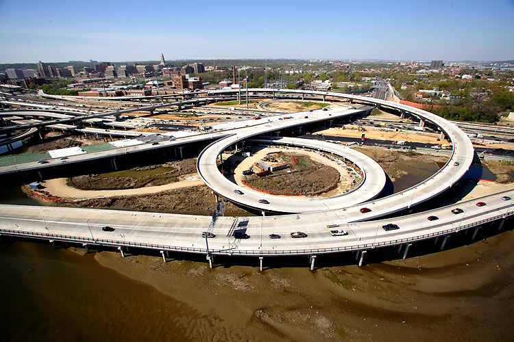
U.S. Route
1 Interchange construction, looking north across Hunting Creek and the I-95/I-495
Capital Beltway, with Alexandria on the north side of the Beltway.
Notice the new 3-lane southbound US-1 bridge under construction, which passes over Hunting Creek, low-lying land, and the Beltway. The new 3-lane northbound US-1 bridge is temporarily carrying 2 lanes each way. |
 |
U.S. Route 1 Interchange construction, looking northwest across Hunting Creek and the I-95/I-495 Capital Beltway, with Alexandria on the north side of the Beltway. |
 |
U.S. Route 1 Interchange construction, looking northwest across Hunting Creek and the I-95/I-495 Capital Beltway. |
 |
U.S. Route
1 Interchange construction, looking west across Hunting Creek and the I-95/I-495
Capital Beltway.
The pedestrian/bicycle path (not yet open in this photo) that will connect US-1 to Washington Street and the WWB pedestrian/bicycle path, is visible along the left side of the bridged ramp in the left side of the photo. |
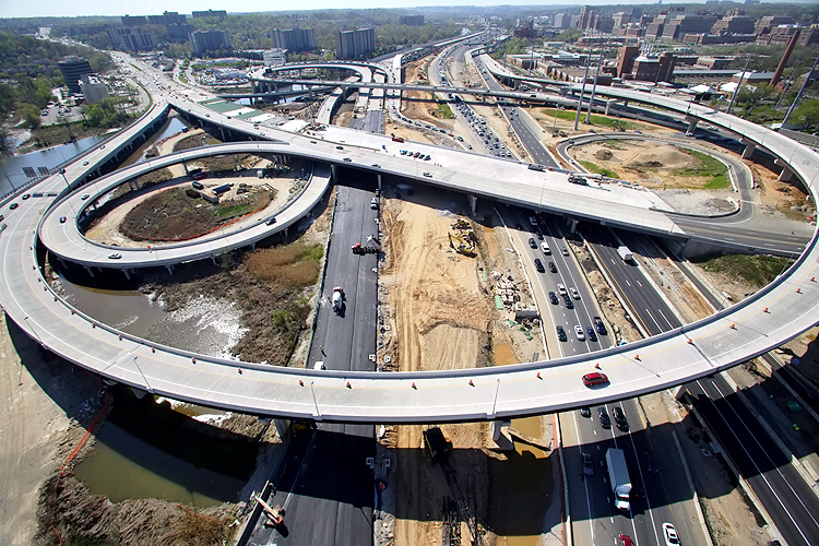 |
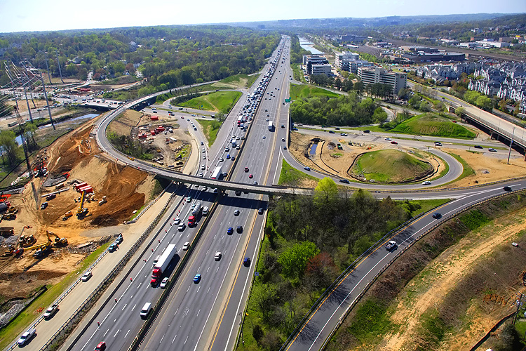
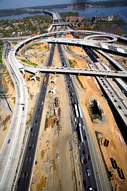
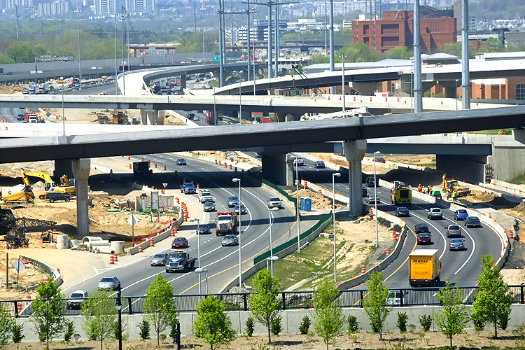
Looking
west along the I-95/I-495 Capital Beltway, showing construction of the U.S.
Route 1 Interchange.
Notice the new 3-lane southbound US-1 bridge under construction, which passes over Hunting Creek, low-lying land, and the Beltway. The new 3-lane northbound US-1 bridge is temporarily carrying 2 lanes each way. A segment of the Beltway Inner Loop local roadway was completed in November 2007, and it extends from near Washington Street almost to VA-241 Telegraph Road, and that is visible to the right. The under construction Beltway roadway to the left, is the Beltway Outer Loop local roadway. |
 |
Looking west along the I-95/I-495 Capital Beltway, showing construction of the U.S. Route 1 Interchange. |
 |
Looking
south along US-1, showing construction of the U.S. Route 1 Interchange.
Notice the new 3-lane southbound US-1 bridge under construction, which passes over Hunting Creek, low-lying land, and the Beltway. The new 3-lane northbound US-1 bridge is temporarily carrying 2 lanes each way. |
 |
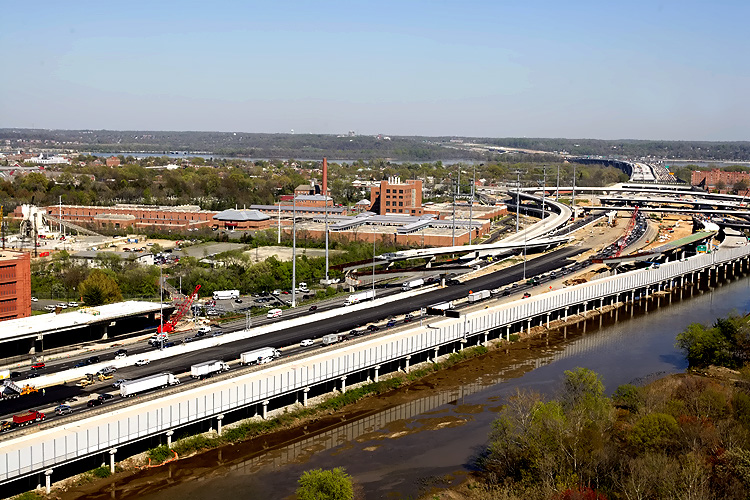
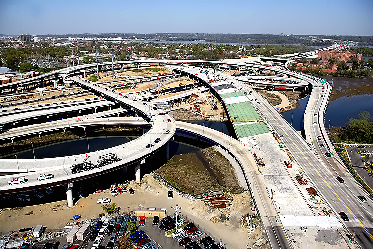
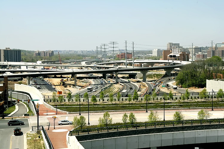
The I-95/I-495 Capital Beltway runs bottom to top, Hunting Creek (also known as Cameron Run) is just to the right of the Beltway, the Potomac River is in the upper part of the photo, the U.S. Route 1 Interchange construction is in the center part of the photo, and the Woodrow Wilson Bridge, and Maryland, is in the upper part of the photo. |
 |
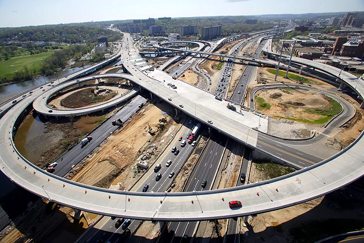
The I-95/I-495
Capital Beltway runs bottom to top, the Potomac River is in the upper part
of the photo, the U.S. Route 1 Interchange construction is in the upper part
of the photo, and the Woodrow Wilson Bridge, and Maryland, is in the upper
part of the photo.
A segment of the Beltway Inner Loop local roadway was completed in November 2007, and it extends from near Washington Street almost to VA-241 Telegraph Road, and that is visible to the left. |
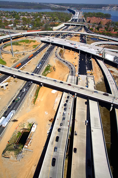 |
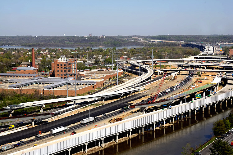
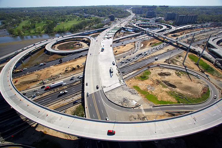
The I-95/I-495
Capital Beltway runs bottom to top, the Potomac River is in the upper part
of the photo, the U.S. Route 1 Interchange construction is in the center part
of the photo, and the Woodrow Wilson Bridge, and Maryland, is in the upper
part of the photo.
The under construction Beltway roadway to the right, is the Beltway Outer Loop local roadway. |
 |
This is
a zoom-in excerpt (size 542 kilobytes) from the previous photo.
LARGE PHOTO Notice the US-1 bridges in the lower part of the photo. |
 |
U.S. Route
1 Interchange construction, looking north across Hunting Creek and the I-95/I-495
Capital Beltway, with Alexandria on the north side of the Beltway.
Notice the new 3-lane southbound US-1 bridge under construction, which passes over Hunting Creek, low-lying land, and the Beltway. The new 3-lane northbound US-1 bridge is temporarily carrying 2 lanes each way. |
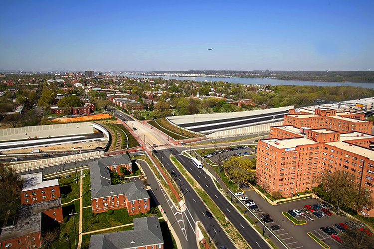 |
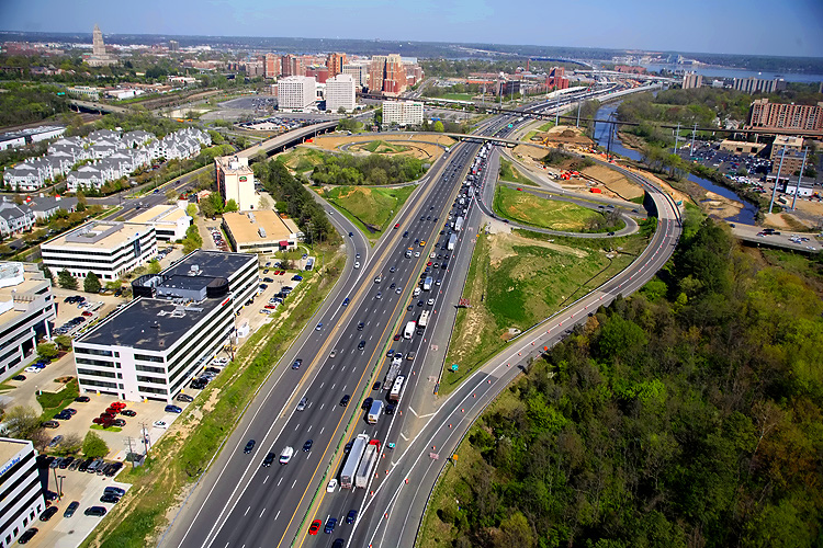
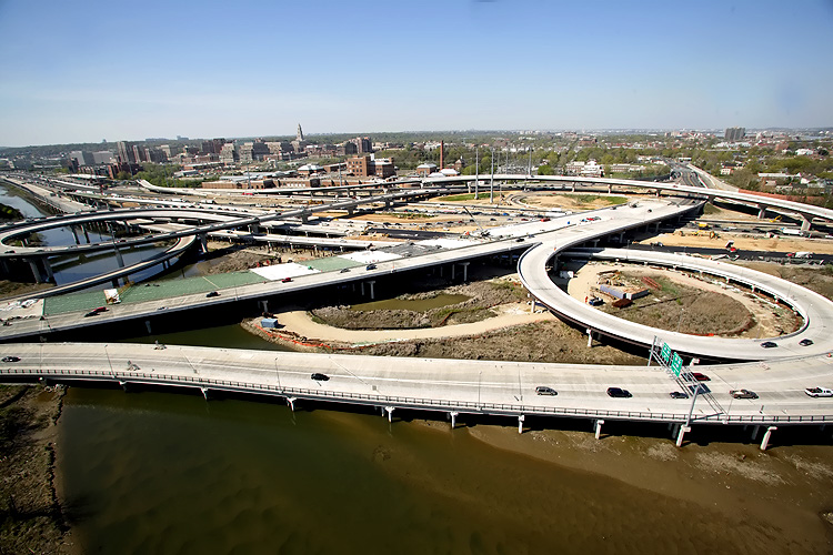
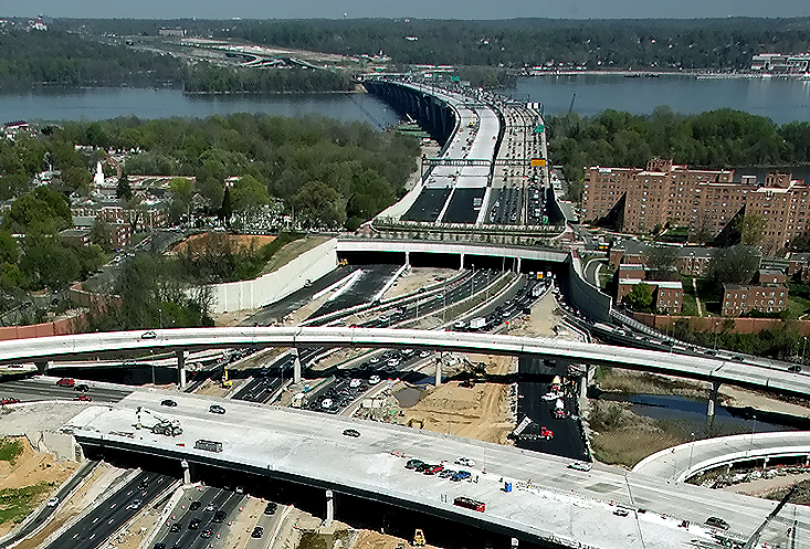
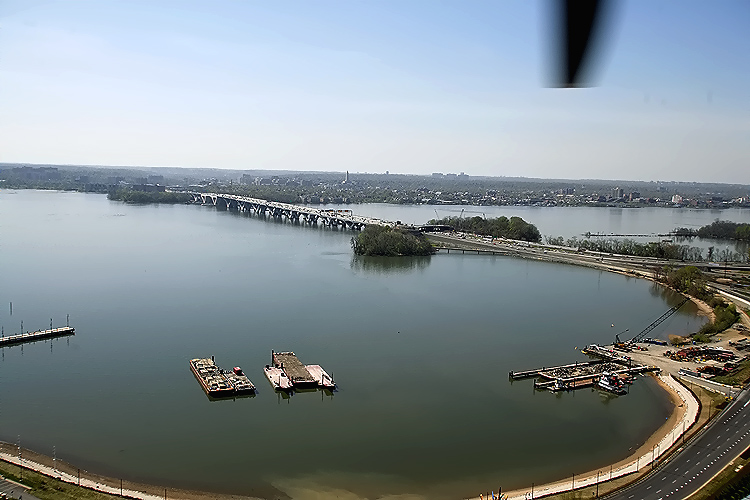
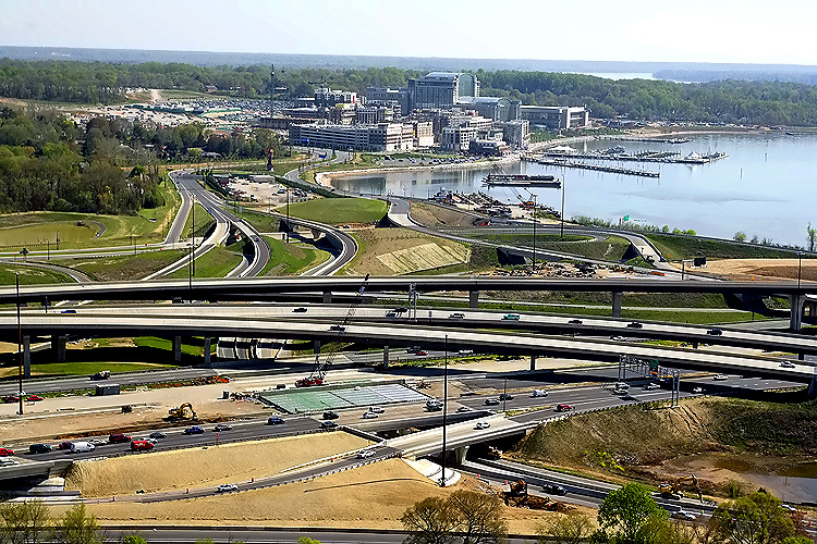
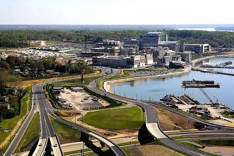
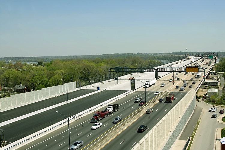
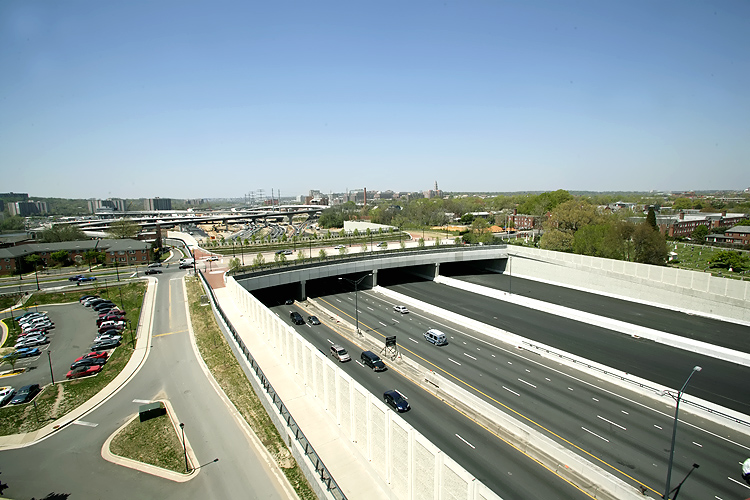
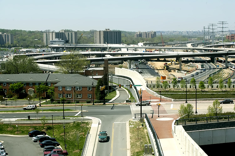
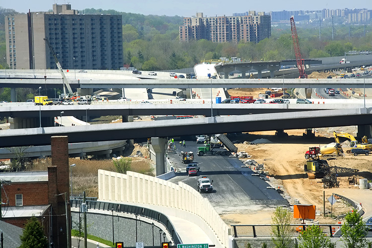
Mount Vernon Memorial Highway runs from the bottom of the photo, upward past the apartment complex where the Mount Vernon Memorial Highway becomes Washington Street, and Washington Street crosses the Beltway and goes into Old Town Alexandria. The Beltway runs left-right across the center of the photo. The Washington Street Urban Deck is in the center of the photo. Old Town Alexandria is in the upper part of the photo, and National Airport, downtown Washington, D.C., and the Washington Monument is in the far distance. |
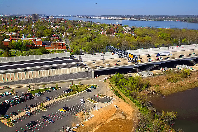 |
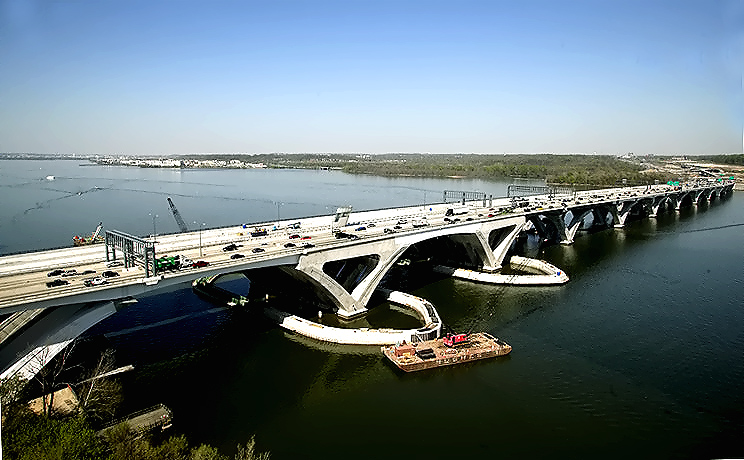
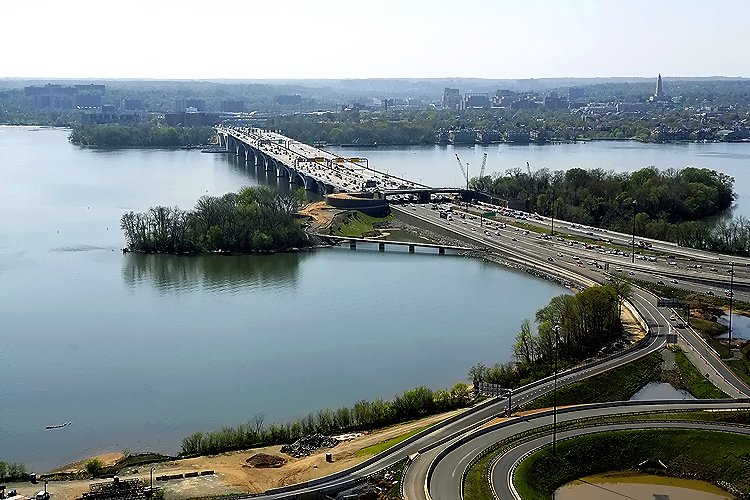
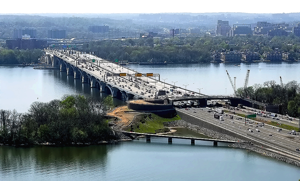
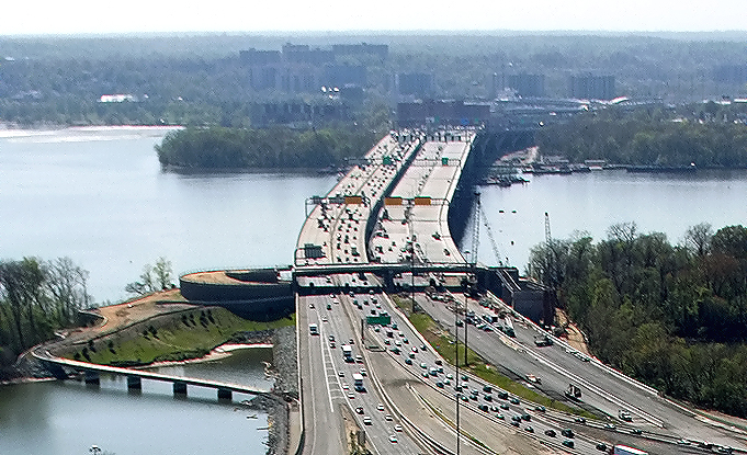
Virginia approaches construction to the Potomac River Bridge, looking north. The new 6-lane Outer Loop WWB is visible, and it is carrying 3 lanes each way until the second new 6-lane Inner Loop WWB, which is under construction above the new bridge, opens to traffic in mid-2008. The new Virginia abutment for the Potomac River Bridge is visible in the left of the photo. Old Town Alexandria is in the upper part of the photo, and National Airport, downtown Washington, D.C., and the Washington Monument is in the far distance. |
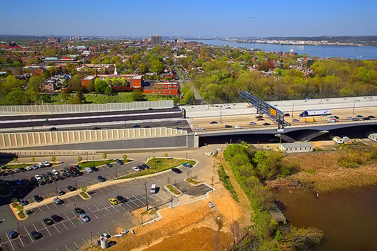 |
Virginia approaches construction to the Potomac River Bridge (Woodrow Wilson Bridge), looking north. |
 |
Virginia approaches construction to the Potomac River Bridge, looking north. |
 |
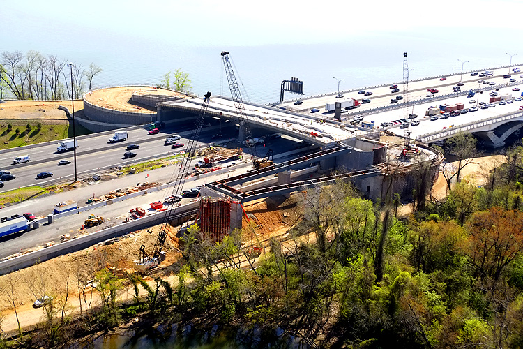
Potomac River Bridge construction, view of the Bascule Span construction. The new bascule span has 70 feet of vertical navigational clearance when the drawspan is closed, 20 feet higher than the original bridge's bascule span which had 50 feet of vertical navigational clearance when its drawspan was closed. |
 |
Potomac River Bridge construction, view of the bascule span, notice the fender ring under construction around the waterline of the piers. The fender is to prevent barges and ships from being able to collide with the pier. |
 |
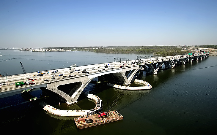
Potomac River Bridge (Woodrow Wilson Bridge) construction, looking northeast. The Maryland abutment for the new Potomac River Bridge is visible in the right of the photo. Interstate 295 Interchange construction, is to the right. |
 |
Potomac River Bridge construction, looking northeast. The Maryland abutment for the new Potomac River Bridge is visible in the center of the photo. Interstate 295 Interchange construction, is to the right. |
 |
Potomac River Bridge (Woodrow Wilson Bridge) construction, looking west. Virginia and Old Town Alexandria is on the opposite side of the Potomac River, and Maryland is on the near side of the river. |
 |
Potomac River Bridge construction, looking west. Virginia and Old Town Alexandria is on the opposite side of the Potomac River, and Maryland is on the near side of the river. |
 |
This is
a zoom-in excerpt (size 711 kilobytes) from the previous photo.
LARGE PHOTO Larger image (size 1,959 kilobytes) |
 |
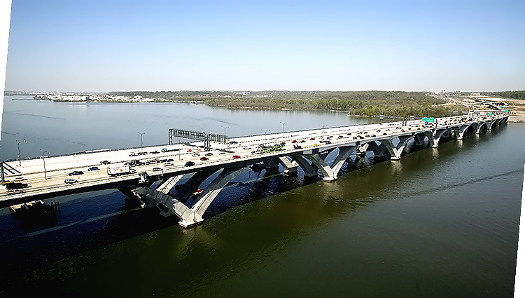
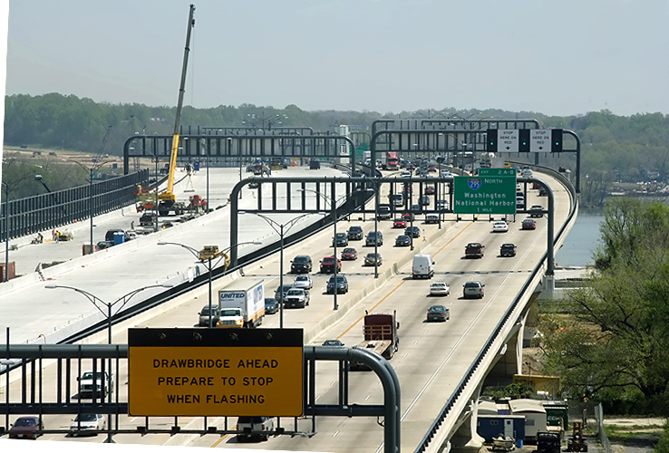
Interstate 295 Interchange construction, looking west along the I-95/I-495 Beltway. The Woodrow Wilson Bridge across the Potomac River is in the upper center part of the photo. |
 |
Looking
west along the I-95/I-495 Beltway, the Woodrow Wilson Bridge.
This is a zoom-in excerpt (size 338 kilobytes) from the previous photo.
|
 |
Potomac River Bridge (Woodrow Wilson Bridge) construction, view of the Maryland Approach Spans construction. The Maryland abutment (terminal structure) of the new Potomac River Bridge is visible in the center of the photo, on Rosalie Island. Land Beltway roadway construction, between Rosalie Island and the Maryland mainland, is to the left. The overpass near the end of the WWB, is part of the pedestrian/bicycle path that will connect the two states via a separated path along the right edge of the under-construction Inner Loop WWB. Notice the pedestrian path under construction between Rosalie Island and the Maryland mainland. The trail will carry pedestrian/bicycle traffic between US-1 south of Alexandria and pedestrian/bicycle trails in Maryland. |
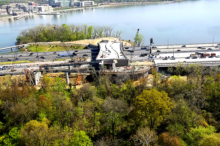 |
The Maryland
abutment (terminal structure) of the new Potomac River Bridge is visible in
the center of the photo, on Rosalie Island. Land Beltway roadway construction,
between Rosalie Island and the Maryland mainland, is to the left. The overpass
near the end of the WWB, is part of the pedestrian/bicycle path that will
connect the two states via a separated path along the right edge of the under-construction
Inner Loop WWB. The pedestrian/bicycle path will open to traffic in early
2009.
Looking south. National Harbor construction is visible in the distance. |
 |
Interstate
295 Interchange construction, looking south. The long bridges carry I-295
over the I-95/I-495 Beltway. High capacity roadways and ramps have been constructed
to make this a 4-way interchange, with the southerly extension heading into
the National Harbor development which began construction in 2004, and which
is visible in the distance.
Website for National Harbor. |
 |
Interstate 295 Interchange construction, looking south, the National Harbor development is visible in the distance. |
 |
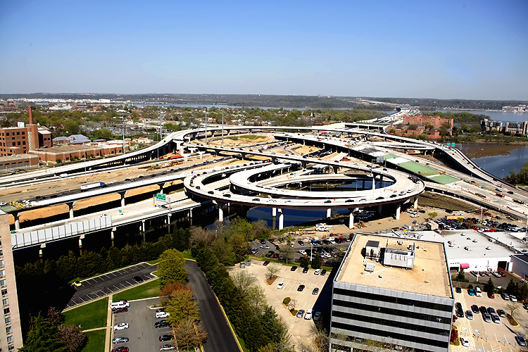
Maryland MD-210 Indian Head Highway Interchange construction, looking north. MD-210 runs from lower right to upper left, and the Beltway runs left to right across the upper middle of the photo. The curving roadways across the lower middle of the photo, are the high speed roadways that connect MD-210 to I-295. |
 |
MD-210 Indian Head Highway Interchange construction, looking west along the I-95/I-495 Capital Beltway. The I-295 interchange, the Woodrow Wilson Bridge, the Potomac River, and Virginia, is in the distance. |
 |
MD-210 Indian Head Highway Interchange construction, looking west along the I-95/I-495 Capital Beltway. The I-295 interchange, the Woodrow Wilson Bridge, the Potomac River, and Virginia, is in the distance. |
 |
MD-210 Indian Head Highway Interchange construction, looking west along the I-95/I-495 Capital Beltway. The I-295 interchange, the Woodrow Wilson Bridge, the Potomac River, and Virginia, is in the distance. |
 |
Maryland MD-210 Indian Head Highway Interchange construction, looking south. MD-210 runs from lower right to upper left, and the Beltway runs from lower left to upper right. |
 |
MD-210 Indian Head Highway Interchange construction, looking south. MD-210 runs from lower left to upper right, and the Beltway runs left to right across the upper middle of the photo. |
The following 32 ground-level photos show various views of the I-95/I-495 Woodrow Wilson Bridge (WWB) Project construction, including the new Potomac River Bridge construction, the Virginia U.S. Route 1 Interchange construction, the Washington Street Urban Deck construction, and the Maryland Interstate 295 Interchange construction.
These photos were taken on April 18, 2008 by the Virginia Department of Transportation, and are posted here with their permission. Roads to the Future utilized PhotoDeluxe Business Edition to sharpen and brighten and to align all of the photos. Click on the photo to get a large version of the photo. In later versions of Netscape and Internet Explorer, you probably will need to use Full Screen mode (the F11 key can be utilized to swap back and forth between Full Screen and Regular) to see the full size of the large photo without browser-induced image shrinkage. The large photos have sizes ranging from 124 to 292 kilobytes, with most of them being under 202 kilobytes. The photos marked "LARGE PHOTO" are much larger, with a very detailed zoom-in of the previous photo, and they have the file size listed next to the photo. With a broadband or network Internet connection each photo will download within seconds, but with a dial-up Internet connection it will be somewhat slower.
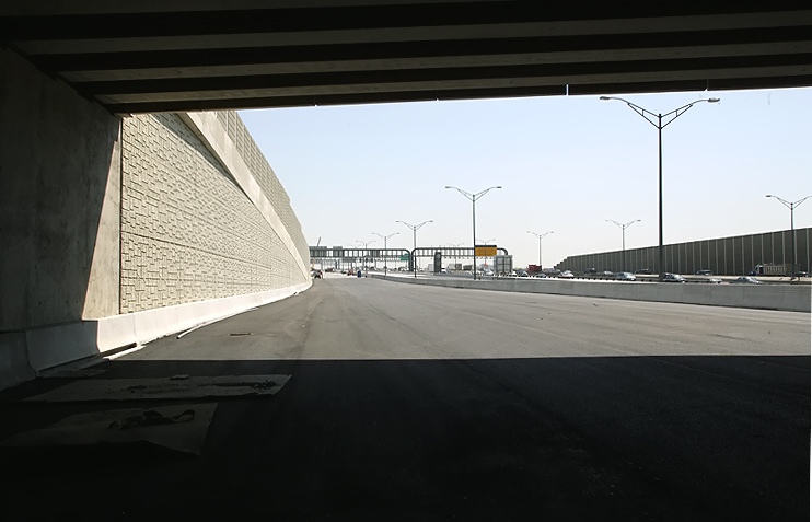 |
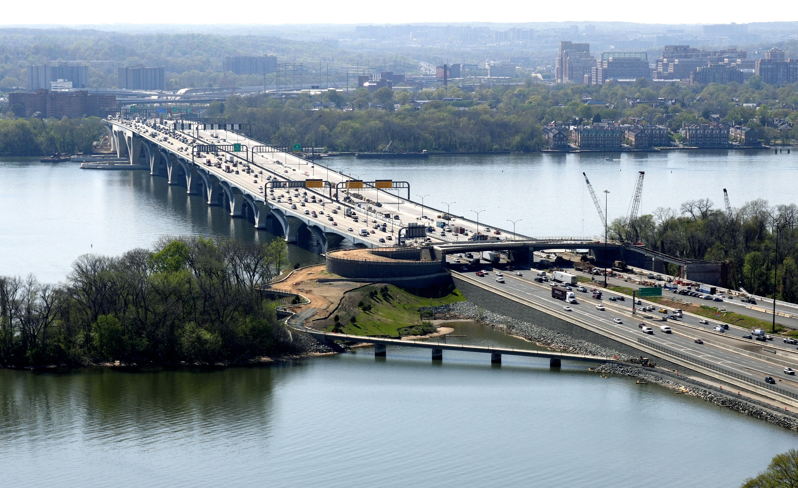
Virginia land approaches construction to the Potomac River Bridge (Woodrow Wilson Bridge), for the Inner Loop bridge, nearing completion. This roadway is the local (outer) roadway of the Inner Loop (Virginia bound) of the Beltway. Standing under the Washington Street Urban Deck, looking against the flow (toward WWB and Maryland) of the future traffic. The overhead sign trusses in the distance, are over the WWB near its Virginia end. |
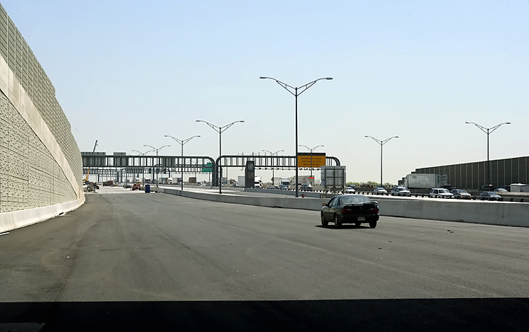 |
Virginia land approaches construction to the Potomac River Bridge, for the Inner Loop bridge, nearing completion. This roadway is the local (outer) roadway of the Inner Loop (Virginia bound) of the Beltway. Looking against the flow (toward WWB and Maryland) of the future traffic. The overhead sign trusses in the distance, are over the WWB near its Virginia end. |
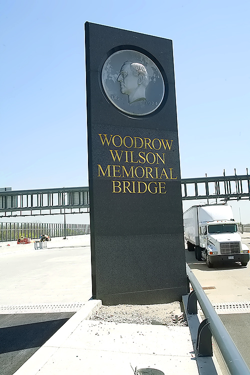 |
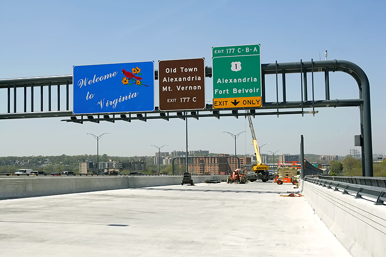
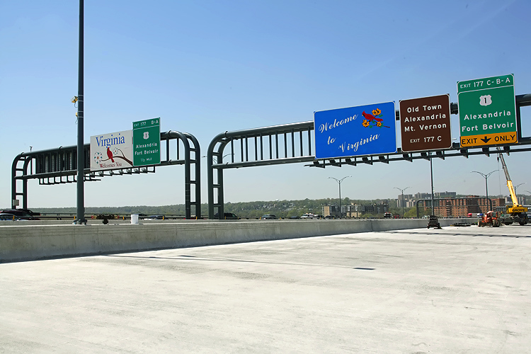
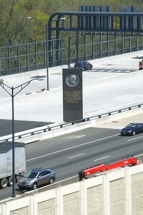
WWB Project construction, the new pylon with the name of the new bridge, carrying the same name as the original bridge, the Woodrow Wilson Memorial Bridge, and carrying the same medallion of President Woodrow Wilson which was formerly on the side of the original bridge's drawspan control tower. |
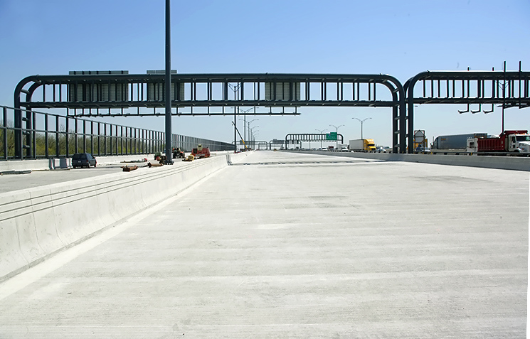 |
Potomac River Bridge 6-lane Inner Loop bridge, nearing completion. This roadway is the 3-lane express (inner) roadway of the Inner Loop (Virginia bound) of the Beltway. Standing near the Virginia end of the WWB, looking against the flow (toward Maryland) of the future traffic. |
 |
Potomac River Bridge 6-lane Inner Loop bridge, nearing completion. Standing on the concrete median barrier between the 3-lane local (outer) roadway and 3-lane express (inner) roadway of the Inner Loop (Virginia bound) of the Beltway. Standing near the Virginia end of the WWB, looking against the flow (toward Maryland) of the future traffic. |
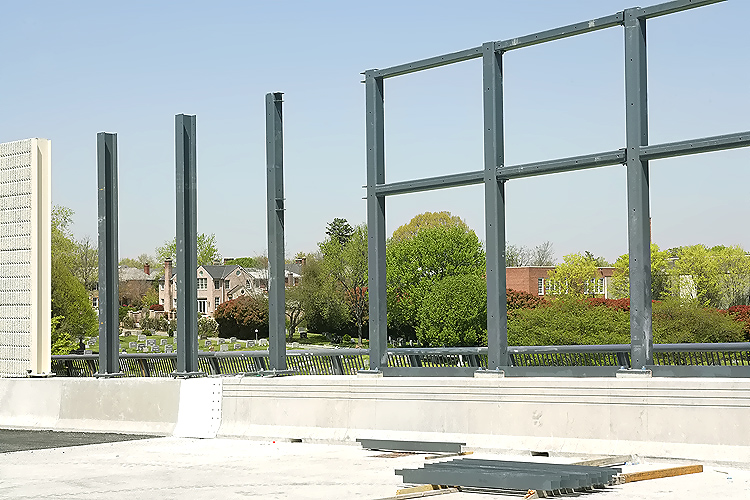 |
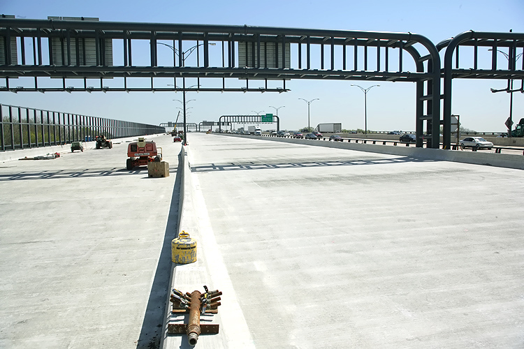
Potomac River Bridge 6-lane Inner Loop bridge, Virginia approach, looking at sound barrier under construction along the north side of the bridge, to reduce the noise impacts to Old Town Alexandria VA. |
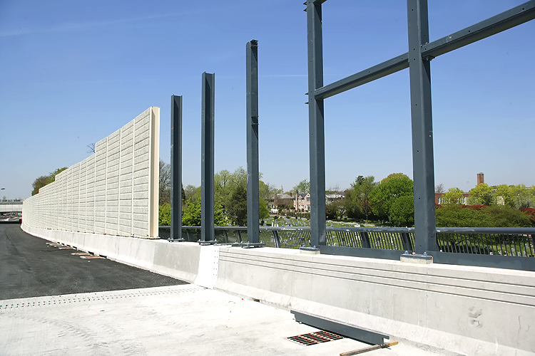 |
Potomac River Bridge 6-lane Inner Loop bridge, Virginia approach, looking at sound barrier under construction along the north side of the bridge, to reduce the noise impacts to Old Town Alexandria VA. The Virginia end of the Potomac River Bridge is where the bridge roadway deck's concrete (beige color) meets the land roadway asphalt pavement (black color). Conventional concrete wall is being used for the sound barrier on the land approach. A 1,550-foot transparent wall on the new Wilson Bridge will provide soundproofing for Old Town Alexandria residents while preserving the view from the bridge; and the wall, made of acrylic panels called Paraglas, will be 17 feet tall. |
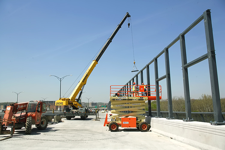 |
Potomac River Bridge 6-lane Inner Loop bridge, Virginia approach, looking at sound barrier under construction along the north side of the bridge, to reduce the noise impacts to Old Town Alexandria VA. Notice crane lifting segment of sound barrier. |
 |
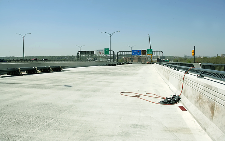
Potomac River Bridge 6-lane Inner Loop bridge, nearing completion. This roadway is the 3-lane local (outer) roadway of the Inner Loop (Virginia bound) of the Beltway. The Virginia Potomac River shoreline is almost directly under the Virginia welcome sign. |
 |
Potomac River Bridge 6-lane Inner Loop bridge, nearing completion. This roadway is the 3-lane local (outer) roadway of the Inner Loop (Virginia bound) of the Beltway. |
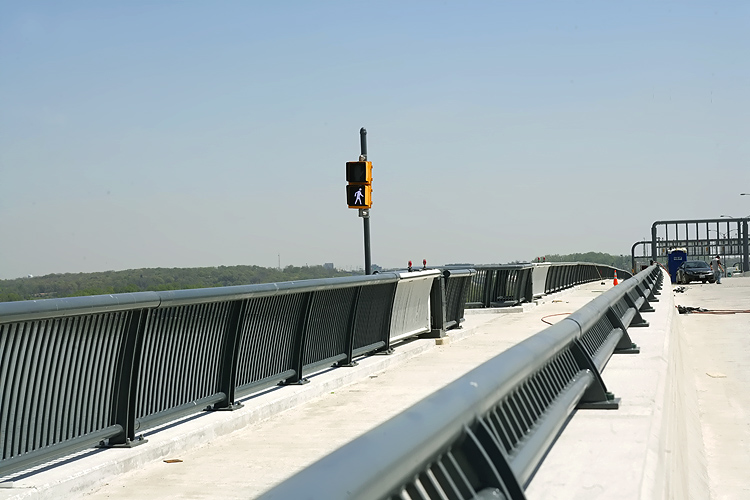 |
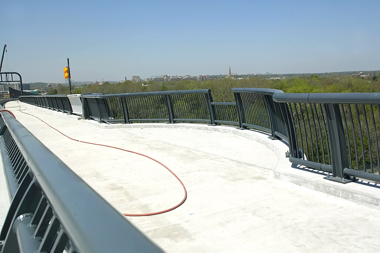
Potomac River Bridge 6-lane Inner Loop bridge, nearing completion. This roadway is the local (outer) roadway of the Inner Loop (Virginia bound) of the Beltway. Standing near the concrete parapet between the roadway and the pedestrian path to the left on the other side of the concrete barrier; there will be a separate pedestrian/bicycle trail on the north side of the second new Woodrow Wilson Bridge, and the trail will carry pedestrian and bicycle traffic between US-1 south of Alexandria and pedestrian/bicycle trails in Maryland. Looking against the flow (toward Maryland) of the future traffic. The signal light in the center of the photo, is to stop pedestrians at that point if the drawspan is to be raised. |
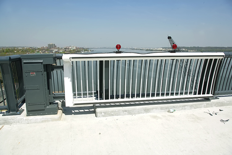 |
Potomac
River Bridge 6-lane Inner Loop bridge, nearing completion. The white-painted
gate swings out 90 degrees to stop pedestrians at that point if the drawspan
is to be raised.
This view is looking north along the Potomac River, with Old Town Alexandria to the left and with downtown Washington, D.C. in the distance. If you look carefully along the left edge of the river, you can see the Washington Monument in the far distance. There will be great views for pedestrians, indeed! |
 |
Potomac River Bridge 6-lane Inner Loop bridge, nearing completion. This roadway is the local (outer) roadway of the Inner Loop (Virginia bound) of the Beltway. Standing near the concrete parapet between the roadway and the pedestrian path to the right on the other side of the concrete barrier. The widened semi-circular section of the path (of which there will a number of them), is for pedestrians to have a place to view the scenery, and be out of the way of the pedestrian and bicycle traffic. |
 |
Potomac River Bridge 6-lane Inner Loop bridge, nearing completion. This roadway is the 3-lane local (outer) roadway of the new 6-lane Inner Loop Potomac River Bridge. Near the highest point of the bridge (notice the new drawbridge Operator's Tower at the right edge of the photo). Looking against the flow (toward Maryland) of the future traffic. |
 |
Potomac River Bridge 6-lane Inner Loop bridge, nearing completion. This roadway is the 3-lane local (outer) roadway of the new 6-lane Inner Loop Potomac River Bridge. Near the highest point of the bridge. Looking against the flow (toward Maryland) of the future traffic. |
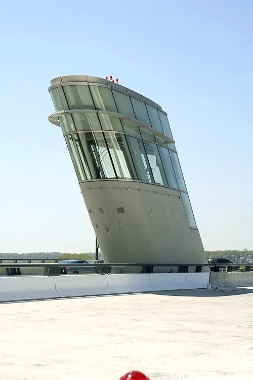 |
The new drawbridge Operator's Tower, which is located between the two new bridges, at the Virginia end of the bascule span. The forward-leaning part of the tower 'leans' over the drawspan to provide the necessary visibility for the operator. This tower is considerably smaller than the original tower, as the higher vertical navigational clearance (70 feet new, versus 50 feet original) under the drawspan when closed, means far fewer (about one per week) drawspan openings will be needed, therefore the human operator will only need to be there occasionally. |
 |
Potomac River Bridge construction, looking west from just west of the bascule spans, looking toward Virginia. To the left is the new 6-lane Outer Loop Potomac River Bridge. This roadway is the 3-lane local (outer) roadway of the under-construction new 6-lane Inner Loop Potomac River Bridge. Notice the pedestrian path to the right on the other side of the concrete barrier; there will be a separate pedestrian/bicycle trail on the north side of the second new Woodrow Wilson Bridge, and the trail will carry pedestrian/bicycle traffic between US-1 south of Alexandria and pedestrian/bicycle trails in Maryland. |
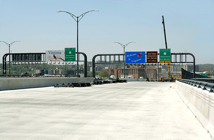 |
Potomac River Bridge 6-lane Inner Loop bridge, nearing completion. This roadway is the 3-lane local (outer) roadway of the Inner Loop (Virginia bound) of the Beltway. The Virginia Potomac River shoreline is almost directly under the Virginia welcome sign. |
 |
WWB Project construction, photo taken from the roof of a Hunting Towers Apartment building in Alexandria, Virginia, showing the recently-opened (in June and July of 2006) new 6-lane Outer Loop Potomac River Bridge, which is currently configured to carry 3 Beltway Outer Loop lanes and 3 Beltway Inner Loop lanes. The new 6-lane Inner Loop Potomac River Bridge, to the left of the Outer Loop bridge, is nearing completion, with all foundations built, all superstructure beams placed, and all of the roadway deck has been constructed. |
 |
WWB Project construction, photo taken from the roof of a Hunting Towers Apartment building. |
 |
WWB Project construction, photo taken from the roof of a Hunting Towers Apartment building. Closer view of the roadway deck construction on the Inner Loop bridge at the Virginia end of the bridge. Notice the new pylon with the name of the new bridge, carrying the same name as the original bridge, the Woodrow Wilson Memorial Bridge, and carrying the same medallion of President Woodrow Wilson which was formerly on the side of the original bridge's drawspan control tower. |
 |
WWB Project
construction, photo taken from the roof of a Hunting Towers Apartment building.
View of the roadway deck construction on the Inner Loop bridge at the Virginia
end of the bridge, and the Virginia land approach construction.
Notice the sound barrier under construction on the north (left) edge of the Inner Loop bridge. A 1,550-foot transparent wall on the new Wilson Bridge will provide soundproofing for Old Town Alexandria residents while preserving the view from the bridge; and the wall, made of acrylic panels called Paraglas, will be 17 feet tall. |
 |
Woodrow Wilson Bridge, photo taken from the roof of a Hunting Towers Apartment building. |
 |
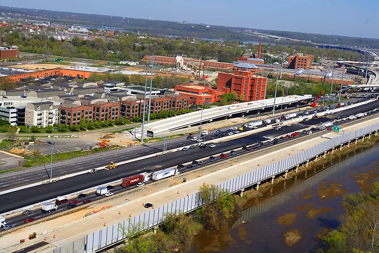
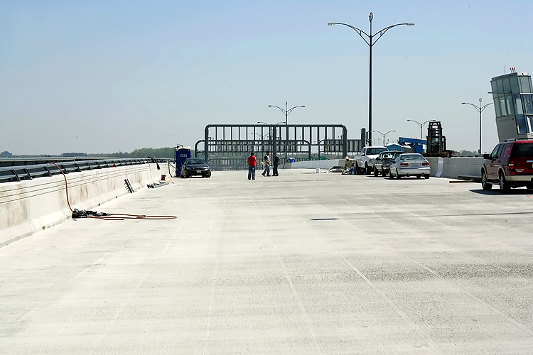
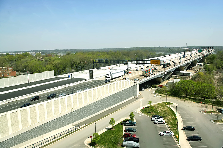
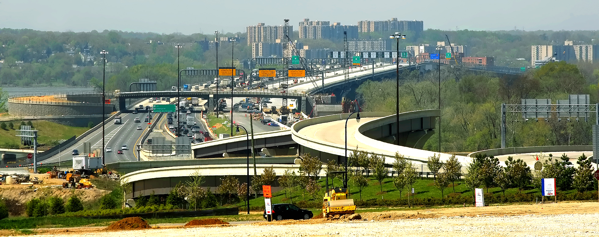
WWB Project construction, photo taken from the roof of a Hunting Towers Apartment building, showing the completed Washington Street Urban Deck in Alexandria VA. Washington Street is the highway that crosses the Beltway, and its traffic was maintained during construction over the Beltway. The completed Washington Street Deck will span the entire reconstructed 12-lane Beltway, and the deck is over 200 feet long and over 200 feet wide, and carries the 4-lane Washington Street with landscaping over the rest of the deck. The Washington Street Urban Deck will remove the 'barrier effect' to pedestrians that would exist with a simple replacement of the 4-lane Washington Street overpass over the 12-lane Beltway. The section of the reconstructed Beltway from the Virginia abutment of the Potomac River Bridge to a couple hundred yards west of the Washington Street Deck and inclusive of the Washington Street Deck, is being built under the US Route 1 Interchange Tie-In contract. |
 |
WWB Project construction, photo taken from the roof of a Hunting Towers Apartment building, showing part of the Washington Street Urban Deck, with construction of the Beltway U.S. Route 1 Interchange in the distance. |
 |
WWB Project construction, photo taken from the roof of a Hunting Towers Apartment building, showing part of the Washington Street Urban Deck, with construction of the Beltway U.S. Route 1 Interchange in the distance. |
 |
WWB Project construction, photo taken from the roof of a Hunting Towers Apartment building, showing part of the Washington Street Urban Deck, with construction of the Beltway U.S. Route 1 Interchange in the distance. |
 |
WWB Project construction, photo taken from the roof of a Hunting Towers Apartment building, showing part of the Washington Street Urban Deck, with construction of the Beltway U.S. Route 1 Interchange in the distance. |
 |
WWB Project construction, photo taken from the roof of a Hunting Towers Apartment building, showing part of the Washington Street Urban Deck, with construction of the Beltway U.S. Route 1 Interchange in the distance. |
 |
WWB Project construction, photo taken from the roof of a Hunting Towers Apartment building, showing part of the Washington Street Urban Deck, with construction of the Beltway U.S. Route 1 Interchange in the distance. Telephoto shot that shows the temporary Beltway roadways that connect the new 6-lane Outer Loop Potomac River Bridge to the pre-existing Beltway roadways. This is part of the US Route 1 Interchange Tie-In contract, and the reverse-curve "tie-in" is where the contract got its name. |
 |
WWB Project construction, photo taken from the roof of a Hunting Towers Apartment building, showing construction of the Beltway U.S. Route 1 Interchange. Telephoto shot that shows the under construction 3-lane Outer Loop local roadway, notice the paving operations in the center of the photo. |
 |
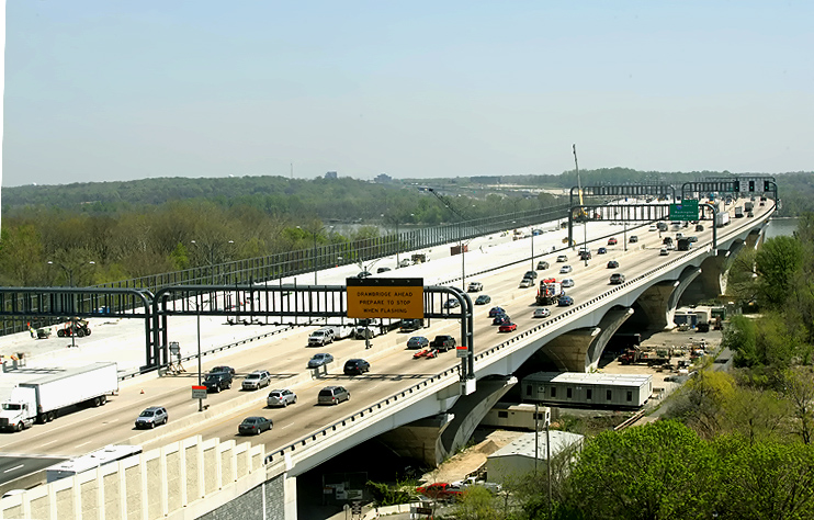
Interstate 295 Interchange and Woodrow Wilson Bridge construction, looking west. Virginia and Old Town Alexandria is on the opposite side of the Potomac River, and Maryland is on the near side of the river. |
 |
This is
a zoom-in excerpt and large version (size 1,916 kilobytes) of the previous
photo. The overpass near the end of the WWB, is part of the pedestrian/bicycle
path that will connect the two states via a separated path along the right
(north) edge of the under-construction Inner Loop WWB, and the trail will
carry pedestrian/bicycle traffic between US-1 south of Alexandria and pedestrian/bicycle
trails in Maryland. LARGE PHOTO |
Lead article - Woodrow Wilson Bridge Project Photos
The group of 45 photos taken on April 17, 2008, were added to this article on October 10, 2008. The group of 32 photos taken on April 18, 2008, were in the original release of article.
Copyright © 2008 by Scott Kozel. All rights reserved. Reproduction, reuse, or distribution without permission is prohibited.
By Scott M. Kozel, Capital Beltway dot com, Roads to the Future
(Created 5-5-2008, last updated 10-10-2008)