
| Woodrow Wilson Bridge Project Photos - April 2006 |
The following 55 photos show various aerial views of the I-95/I-495 Woodrow Wilson Bridge (WWB) Project construction, including the new Potomac River Bridge construction, the Virginia U.S. Route 1 Interchange construction, the Washington Street Urban Deck construction, the Virginia Telegraph Road Interchange construction, and the Maryland Interstate 295 Interchange construction.
These photos were taken on April 28, 2006 by the Virginia Department of Transportation, and are posted here with their permission. Roads to the Future utilized PhotoDeluxe Business Edition to sharpen and brighten and to align all of the photos. Click on the photo to get a large version of the photo. In later versions of Netscape and Internet Explorer, you probably will need to use Full Screen mode (the F11 key can be utilized to swap back and forth between Full Screen and Regular) to see the full size of the large photo without browser-induced image shrinkage. The large photos have sizes ranging from 126 to 264 kilobytes, with most of them being under 214 kilobytes. With a broadband or network Internet connection each photo will download within seconds, but with a dial-up Internet connection it will be somewhat slower.
 |
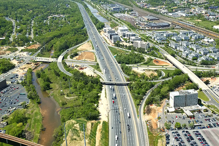
The I-95/I-495 Capital Beltway and
Telegraph Road Interchange, looking north
along
Telegraph Road.
Telegraph Road is a 4- to 6-lane arterial, and
the Beltway interchange is in the center of the photo, The 8-lane I-95/I-495 Capital Beltway runs left to right, Hunting Creek (also known as Cameron Run) is just below the Beltway. The VA-241 Telegraph Road Interchange of the Beltway was originally built in 1961 as a modified cloverleaf interchange with one semi-directional ramp. The road paralleling just above the Beltway is the 4-lane Eisenhower Avenue, and it has a long bridge over Telegraph Road. Telegraph Road runs bottom to top, and its junctions from bottom to top in order are, North Kings Highway, Huntington Avenue and the first offramp from the Beltway Outer Loop (towards Wilson Bridge) to Telegraph Road, the interchange with the Beltway, an interchange with local roads in the Eisenhower Valley, and the northern terminus of Telegraph Road which has a trumpet interchange with VA-236 Duke Street in Alexandria. The mainline of the CSXT Railroad and the Norfolk Southern Railroad parallels between Eisenhower Avenue and VA-236 Duke Street. Telegraph Road mainline bridges in this photo are, over Hunting Creek, over the mainline railroads, and over Duke Street. |
 |
The I-95/I-495 Capital Beltway and Telegraph Road Interchange, looking north along Telegraph Road. |
 |
The I-95/I-495 Capital Beltway and
Telegraph Road Interchange, is partly visible
on the left edge of the photo, the Beltway runs from the lower right to
the middle left. The WMATA Metro rapid rail transit line Huntington Route (Yellow Line trains) runs on aerial structure, lower left to middle right across the lower part of the photo, and its Eisenhower Avenue Station is visible to the right of the Beltway. |
 |
The 8-lane I-95/I-495 Capital Beltway runs bottom to top, and Hunting Creek (also known as Cameron Run) is just to the left of the Beltway. The VA-241 Telegraph Road Interchange of the Beltway is in the center of the photo, and it was originally built in 1961 as a modified cloverleaf interchange with one semi-directional ramp. The road paralleling to the right of the Beltway is the 4-lane Eisenhower Avenue, and it has a long bridge over Telegraph Road. Telegraph Road runs left to right. The WMATA Metro rapid rail transit line runs on aerial structure, across the lower part of the photo, and its Eisenhower Avenue Station is visible to the right of the Beltway. |
 |
The 8-lane I-95/I-495 Capital Beltway runs bottom to top, and Hunting Creek is just to the left of the Beltway. Looking west. The VA-241 Telegraph Road Interchange of the Beltway is in the center of the photo. The road paralleling to the right of the Beltway is the 4-lane Eisenhower Avenue, and it has a long bridge over Telegraph Road. Telegraph Road runs left to right. |
 |
The 8-lane I-95/I-495 Capital Beltway runs bottom to top, and Hunting Creek is just to the left of the Beltway. Looking west. The VA-241 Telegraph Road Interchange of the Beltway is in the center of the photo. The road paralleling to the right of the Beltway is the 4-lane Eisenhower Avenue, and it has a long bridge over Telegraph Road. Telegraph Road runs left to right. The WMATA Metro rapid rail transit line runs on aerial structure, across the lower part of the photo, and its Eisenhower Avenue Station is visible to the right of the Beltway. |
 |
The 8-lane I-95/I-495 Capital Beltway runs bottom to top, and Hunting Creek is just to the left of the Beltway. Looking west. The VA-241 Telegraph Road Interchange of the Beltway is in the center of the photo. The road paralleling to the right of the Beltway is the 4-lane Eisenhower Avenue, and it has a long bridge over Telegraph Road. Telegraph Road runs left to right. |
 |
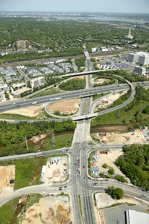
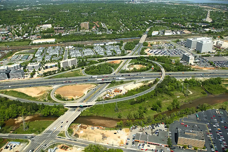
The I-95/I-495 Capital Beltway and Telegraph Road Interchange, looking south along Telegraph Road. Telegraph Road is a 4- to 6-lane arterial, and the Beltway interchange is in the center of the photo. The Beltway runs left to right, Hunting Creek is just above the Beltway. The road paralleling just below the Beltway is the 4-lane Eisenhower Avenue, and it has a long bridge over Telegraph Road. Telegraph Road runs lower right to upper left, and its junctions from top to bottom in order are, North Kings Highway, Huntington Avenue and the first offramp from the Beltway Outer Loop (towards Wilson Bridge) to Telegraph Road, the interchange with the Beltway, an interchange with local roads in the Eisenhower Valley, and off the lower edge of the photo is the northern terminus of Telegraph Road which has a trumpet interchange with VA-236 Duke Street in Alexandria. The mainline of the CSXT Railroad and the Norfolk Southern Railroad parallels between Eisenhower Avenue and VA-236 Duke Street, and the railroad is visible in the right of the photo. Telegraph Road mainline bridges in this photo are, over Hunting Creek, and over the mainline railroads. WMATA Metro rail Service & Inspection Yard is visible in the upper right of the photo. |
 |
The I-95/I-495 Capital Beltway and Telegraph Road Interchange, looking south along Telegraph Road. |
 |
The I-95/I-495 Capital Beltway and Telegraph Road Interchange, looking south along Telegraph Road. |
 |
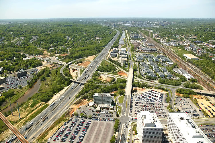
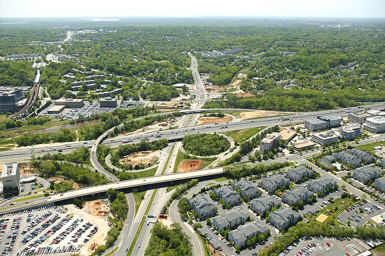
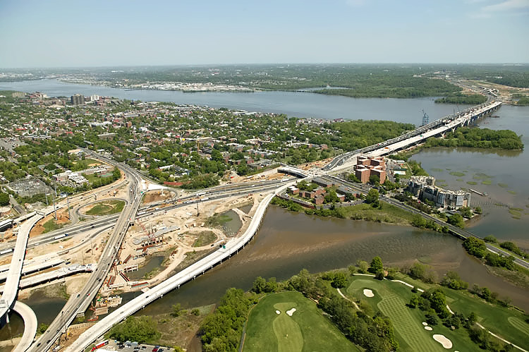
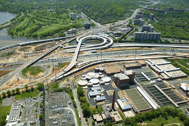
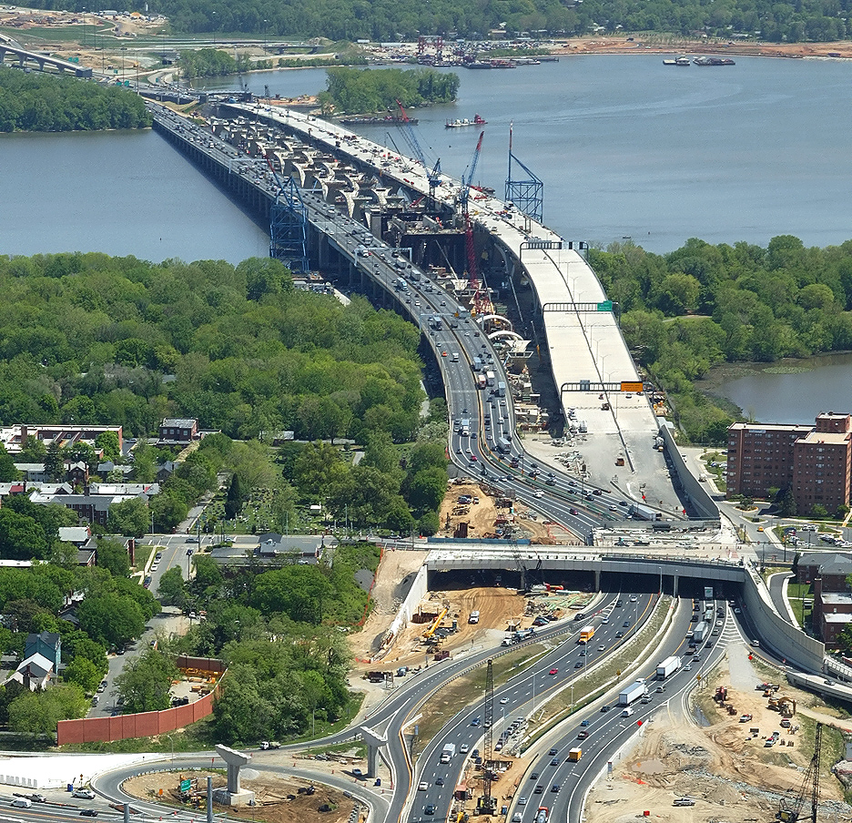
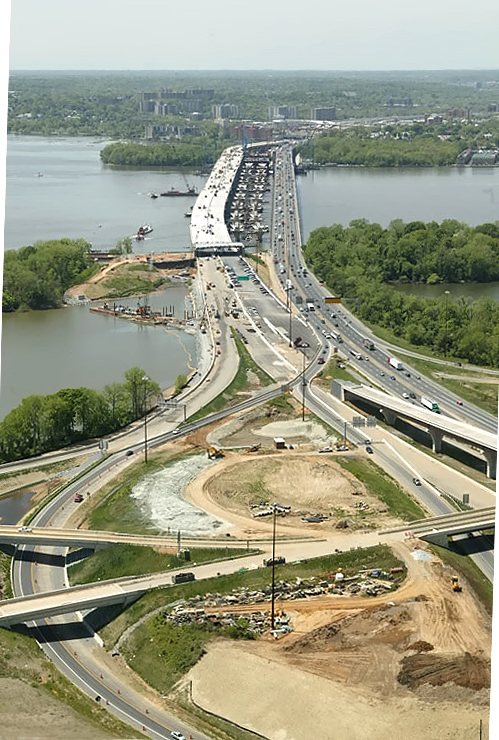
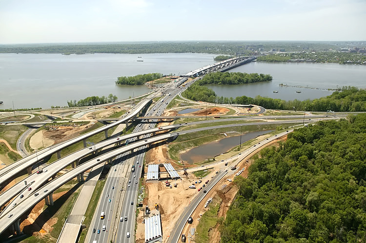
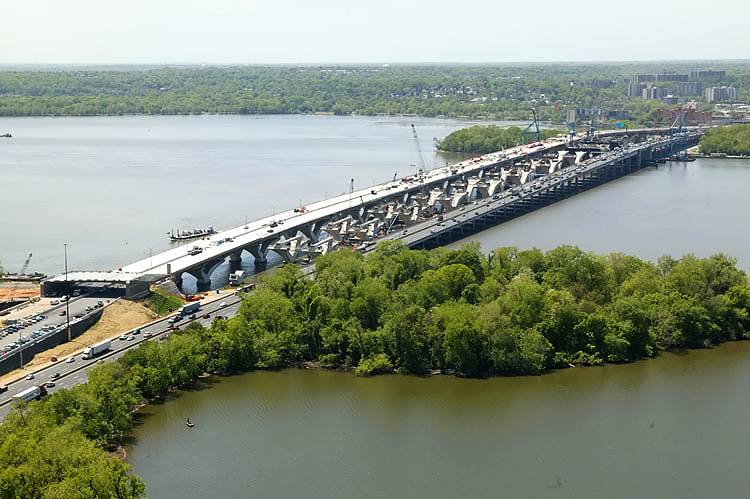
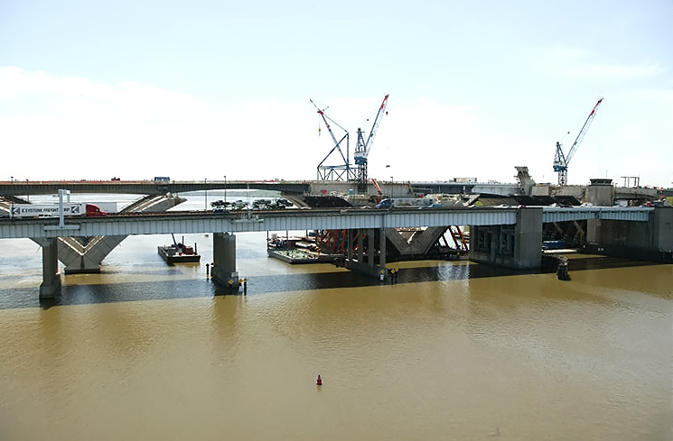
The 8-lane I-95/I-495 Capital Beltway runs bottom to top, Hunting Creek (also known as Cameron Run) is just to the right of the Beltway, the Potomac River is in the upper part of the photo, the U.S. Route 1 Interchange construction is in the upper part of the photo, and the Woodrow Wilson Bridge is in the upper part of the photo. The VA-241 Telegraph Road Interchange of the Beltway is in the center of the photo, and it was originally built in 1961 as a modified cloverleaf interchange with one semi-directional ramp. The road paralleling to the left of the Beltway is the 4-lane Eisenhower Avenue, and it has a long bridge over Telegraph Road. Telegraph Road runs left to right. |
 |
The 8-lane I-95/I-495 Capital Beltway runs bottom to top, Hunting Creek is
just to the right of the Beltway, the Potomac River is in the upper part
of the photo, the U.S. Route 1 Interchange construction is in the upper
part of the photo, and the Woodrow Wilson Bridge is in the upper left of
the photo. The VA-241 Telegraph Road Interchange of the Beltway is in the
lower part of the photo. The 4-lane Eisenhower Avenue
bridge over Telegraph Road is visible in the lower left of the photo.
The WMATA Metro rapid rail transit line Huntington Route (Yellow Line trains) runs on aerial structure left to right across the lower middle of the photo, and its Eisenhower Avenue Station is visible to the left of the Beltway. |
 |
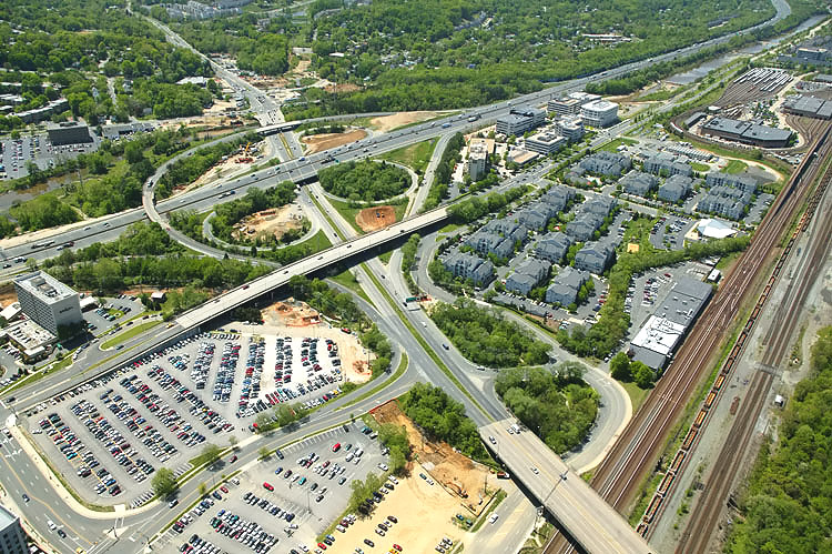
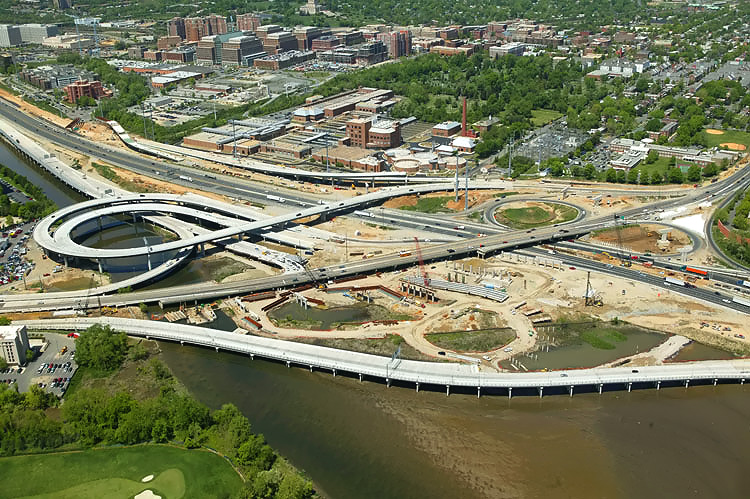
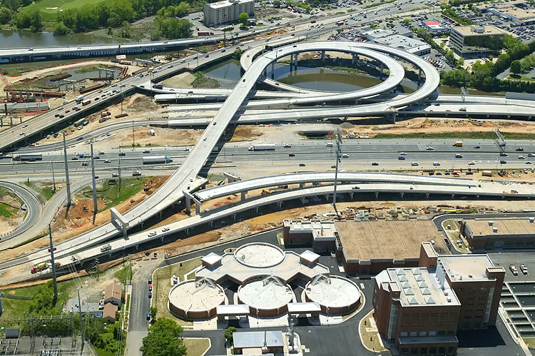
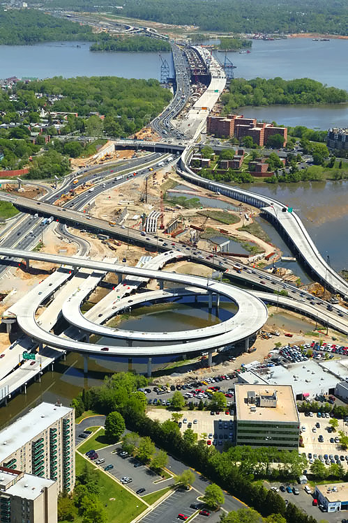
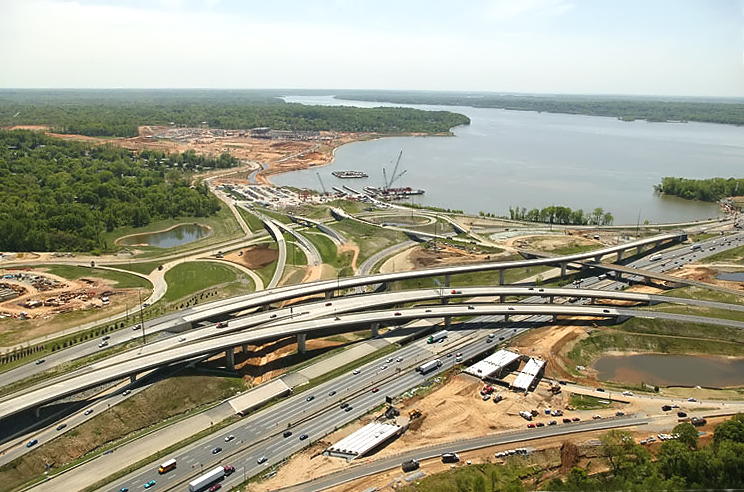
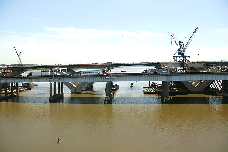
U.S. Route 1 Interchange construction, looking north across Hunting Creek and the I-95/I-495 Capital Beltway, with Alexandria on the north side of the Beltway. The Potomac River is in the upper part of the photo, and the Woodrow Wilson Bridge is in the upper right of the photo. |
 |
U.S. Route 1 Interchange construction, looking north
across Hunting Creek and the I-95/I-495 Capital Beltway, with Alexandria on the
north side of the Beltway. This photo was taken from over US-1, and the
new ramps can be seen on either side of US-1. The two new southerly ramps
connecting the Beltway to US-1 (Outer Loop to US-1 southbound, and US-1
northbound to Outer Loop), were opened to traffic in August and September
2005, respectively. On March 11th, 2006, the new ramp from southbound US-1 in Old Town Alexandria to the Outer Loop opened to traffic, helping to fix US-1’s severely congested access to the Outer Loop of the Beltway. That is the large elevated new loop ramp. The new ramp replaced the original semi-directional flyover ramp connecting southbound US-1 to northbound I-95/I-495 (to Wilson Bridge), and there is a temporary tie-in between the ramp and northbound I-95/I-495, pending the completion of the U.S. Route 1 Interchange segment of the WWB Project. |
 |
U.S. Route 1 Interchange construction, looking north across Hunting Creek and the I-95/I-495 Capital Beltway, with Alexandria on the north side of the Beltway. |
 |
U.S. Route 1 Interchange construction, looking north across Hunting Creek and the I-95/I-495 Capital Beltway, with Alexandria on the north side of the Beltway. The original U.S. Route 1 Interchange had a considerable amount of bridgework across areas of water and low-lying land, with a long bridge on US-1 and bridges on four of the ramps. The original interchange opened to traffic in 1961, with a modified cloverleaf design with a semi-directional flyover ramp connecting southbound US-1 to northbound I-95/I-495 (to Wilson Bridge), and with a collector-distributor (C-D) roadway intercepting the two loop ramps on southbound I-95/I-495. |
 |
U.S. Route 1 Interchange construction, looking north across Hunting Creek, and the I-95/I-495 Capital Beltway, with Alexandria on the north side of the Beltway. The Woodrow Wilson Bridge is to the right. The new ramp from US-1 northbound to the Outer Loop of the Beltway, can be seen in the foreground of the photo, and this bridged ramp has a separate pedestrian/bicycle trail on the east side of the bridge, and the trail carries pedestrian/bicycle traffic between US-1 south of Alexandria and Washington Street and the pedestrian/bicycle trail which will cross the Potomac River on the new Woodrow Wilson Bridge to pedestrian/bicycle trails in Maryland. |
 |
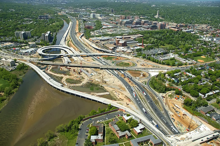
Mount Vernon Memorial Highway runs from the right bottom of the photo, upward past the apartment complex where the Mount Vernon Memorial Highway becomes Washington Street, and Washington Street crosses the Beltway and goes into Old Town Alexandria. The Beltway runs left-right across the center of the photo. |
 |
U.S. Route 1 Interchange construction, looking north across Hunting Creek, and the I-95/I-495 Capital Beltway, with Alexandria on the north side of the Beltway. The new ramp from US-1 northbound to the Outer Loop of the Beltway, can be seen in the foreground of the photo, and this bridged ramp has a separate pedestrian/bicycle trail on the east side of the bridge. |
 |
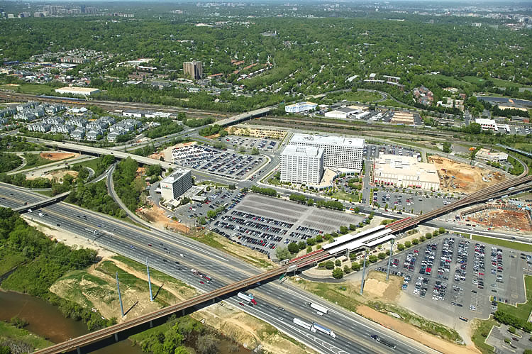
Mount Vernon Memorial Highway runs from the bottom of the photo, upward past the apartment complex where the Mount Vernon Memorial Highway becomes Washington Street, and Washington Street crosses the Beltway and goes into Old Town Alexandria. The Beltway runs left-right across the center of the photo. The Washington Street Urban Deck is under construction in the center of the photo. Old Town Alexandria is in the upper part of the photo, and National Airport, downtown Washington, D.C., and the Washington Monument is in the far distance. |
 |
U.S. Route 1 Interchange construction, looking west across Hunting Creek, and the I-95/I-495 Capital Beltway, with Alexandria on the north side of the Beltway. The new ramp from US-1 northbound to the Outer Loop of the Beltway, can be seen in the left foreground of the photo. The Washington Street Urban Deck is under construction in the lower right of the photo. |
 |
Looking west along the Beltway, showing construction of the Washington Street Urban Deck in Alexandria VA, and the U.S. Route 1 Interchange in the distance. The Washington Street Urban Deck has been completed over the future local and express Beltway Outer Loop roadways, and it is under construction over the future local and express Beltway Inner Loop roadways. |
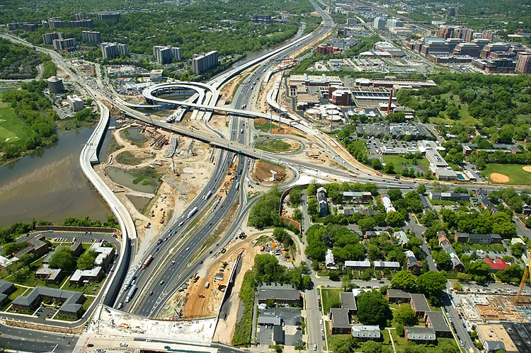 |
Looking west along the Beltway, showing construction of the Washington Street Urban Deck in Alexandria VA, and the U.S. Route 1 Interchange in the distance. |
 |
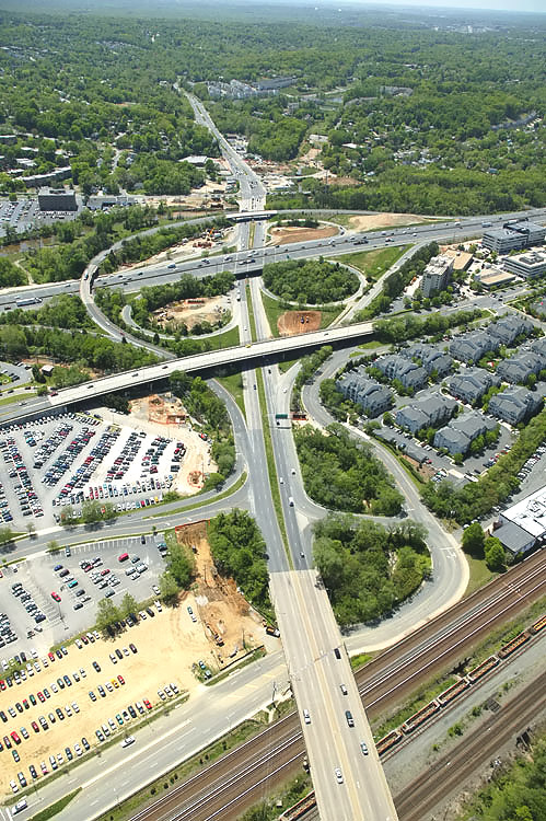
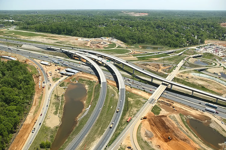
U.S. Route 1 Interchange construction, looking south along U.S. Route 1 which goes into the distance, with the Beltway running left-right. The original U.S. Route 1 Interchange had a considerable amount of bridgework across areas of water and low-lying land, with a long bridge on US-1 and bridges on four of the ramps. The original interchange opened to traffic in 1961, with a modified cloverleaf design with a semi-directional flyover ramp connecting southbound US-1 to northbound I-95/I-495 (to Wilson Bridge), and with a collector-distributor (C-D) roadway intercepting the two loop ramps on southbound I-95/I-495. |
 |
U.S. Route 1 Interchange construction, looking south along U.S. Route 1 which goes into the distance, with the Beltway running left-right. |
 |
U.S. Route 1 Interchange construction, looking south along U.S. Route 1 which goes into the distance, with the Beltway running left-right. |
 |
U.S. Route 1 Interchange construction, looking
south along U.S. Route 1 which goes into the distance, with the Beltway
running left-right.
On March 11th, 2006, the new ramp from southbound US-1 in Old Town Alexandria to the Outer Loop opened to traffic, helping to fix US-1’s severely congested access to the Outer Loop of the Beltway. That is the large elevated new loop ramp. The new ramp replaced the original semi-directional flyover ramp connecting southbound US-1 to northbound I-95/I-495 (to Wilson Bridge), and there is a temporary tie-in between the ramp and northbound I-95/I-495, pending the completion of the U.S. Route 1 Interchange segment of the WWB Project. |
 |
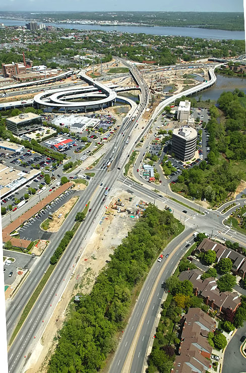
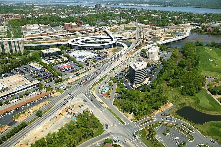
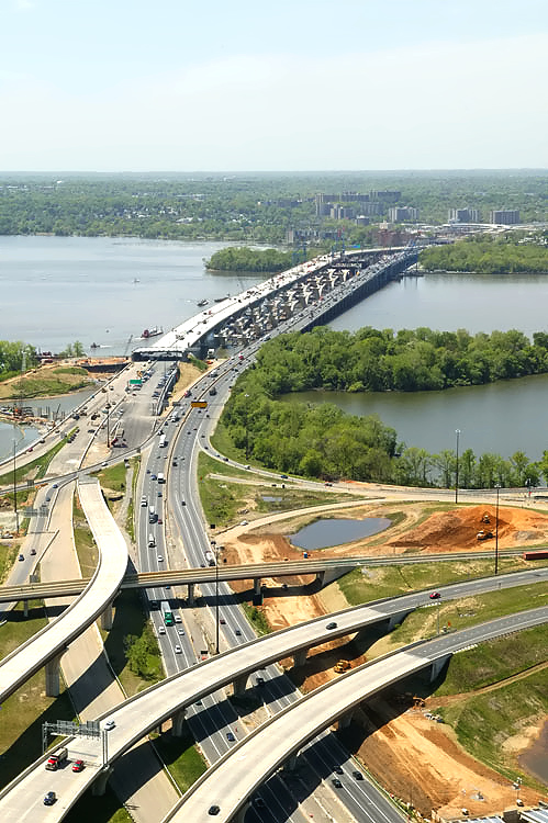
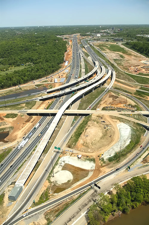
U.S. Route 1 Interchange construction, looking east along the I-95/I-495 Capital Beltway, with Alexandria on the north side of the Beltway, and the Potomac River, the existing and under construction Woodrow Wilson Bridges, and Maryland, visible in the distance. |
 |
U.S. Route
1 Interchange construction, looking east along the I-95/I-495 Capital Beltway, with Alexandria on the north side of the Beltway, and
the Potomac River, the existing and under construction Woodrow Wilson
Bridges, and Maryland, visible in the distance.
The $146.6 million US Route 1 Interchange (Major Portion) contract is 32.2% complete as of May 20, 2006. The $54.6 million US Route 1 Interchange Tie-In contract is 73.9% complete as of May 20, 2006. The other US Route 1 Interchange contracts are complete. |
 |
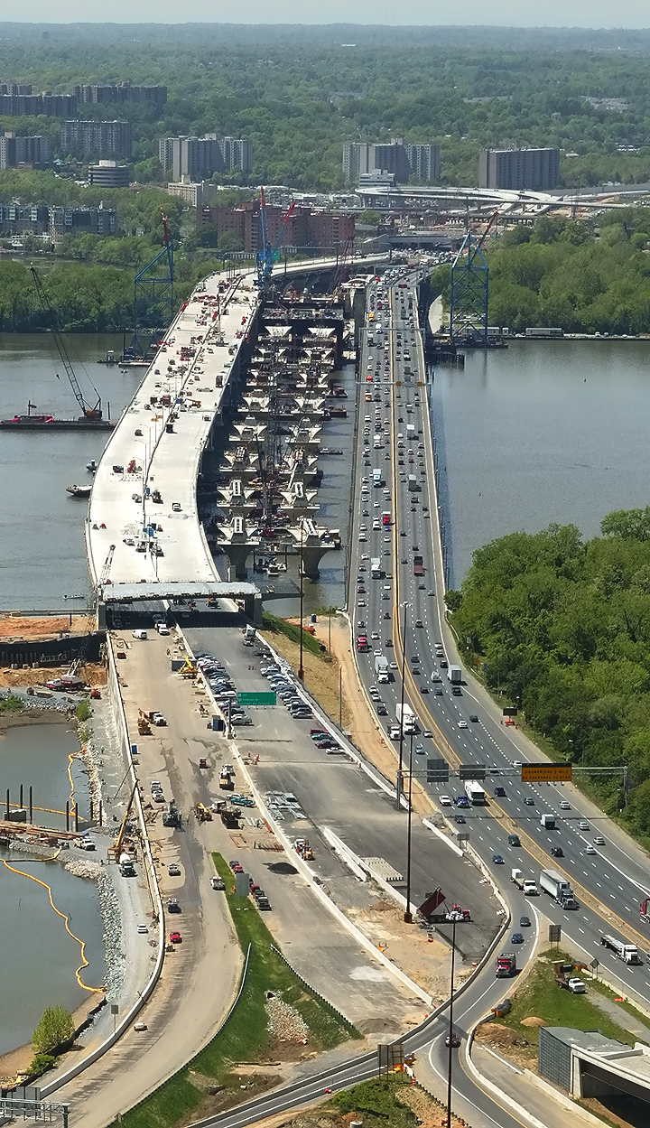
Woodrow Wilson Bridge construction, looking
east along the I-95/I-495 Beltway, from Virginia to Maryland. Work is
proceeding on the northern half of the Washington Street Urban Deck, in
the foreground.
This image is a zoom-in excerpt from the previous image, and is 756 kilobytes in size. |
 |
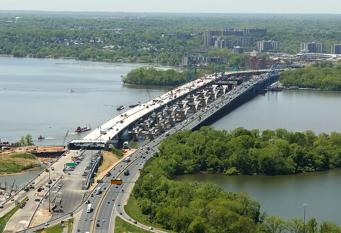
U.S. Route 1 Interchange construction, looking east along the I-95/I-495 Capital Beltway, with Alexandria on the north side of the Beltway, and the Potomac River, the existing and under construction Woodrow Wilson Bridges, and Maryland, visible in the distance. |
 |
U.S. Route
1 Interchange construction, looking east along the I-95/I-495 Capital Beltway, with Alexandria on the north side of the Beltway, and
the Potomac River, the existing and under construction Woodrow Wilson
Bridges, and Maryland, visible in the distance. On March 11th, 2006, the new ramp from southbound US-1 in Old Town Alexandria to the Outer Loop opened to traffic, helping to fix US-1’s severely congested access to the Outer Loop of the Beltway. That is the large elevated new loop ramp. The new ramp replaced the original semi-directional flyover ramp (which has since been demolished) connecting southbound US-1 to northbound I-95/I-495 (to Wilson Bridge), and there is a temporary tie-in between the ramp and northbound I-95/I-495, pending the completion of the U.S. Route 1 Interchange segment of the WWB Project. |
 |
Woodrow Wilson Bridge construction, looking
east along the I-95/I-495 Beltway, from Virginia to Maryland. Work is
proceeding on the northern half of the Washington Street Urban Deck, in
the foreground.
This image is a zoom-in excerpt from the previous image, and is 778 kilobytes in size. |
 |
U.S. Route 1 Interchange construction, looking north, with Alexandria on the north side of the Beltway. US-1 runs from the lower left to the upper center of the photo. The Potomac River and Washington, D.C. is in the distance. |
 |
U.S. Route 1 Interchange construction, looking north across Hunting Creek and the I-95/I-495 Capital Beltway, with Alexandria on the north side of the Beltway. |
 |
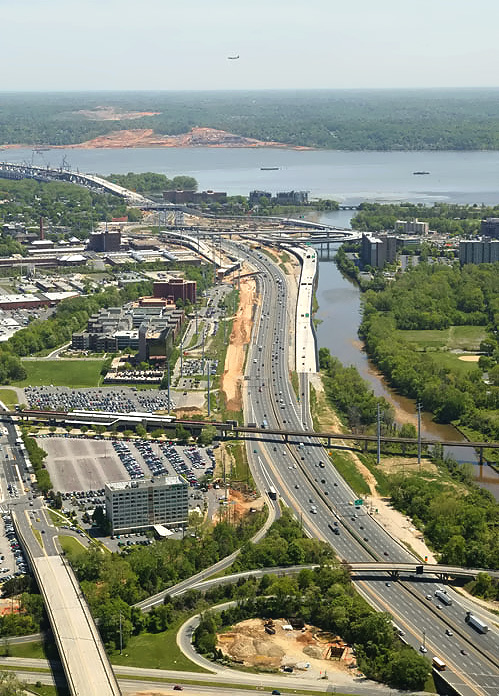
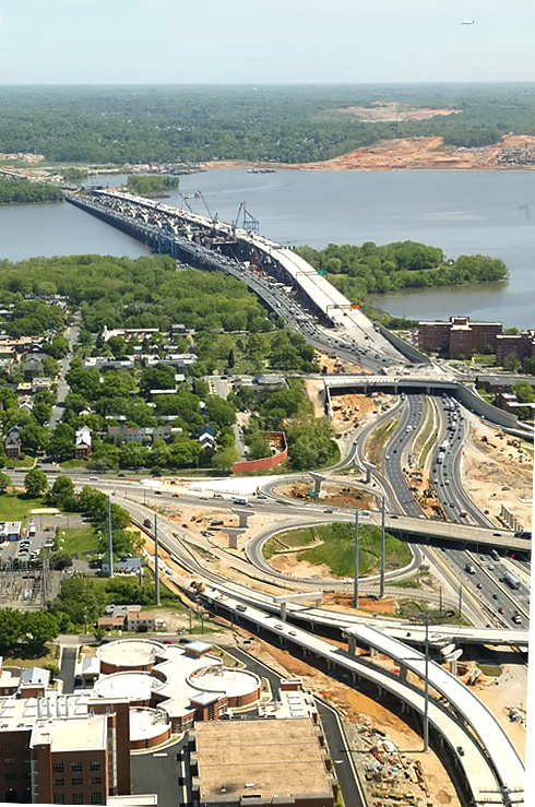
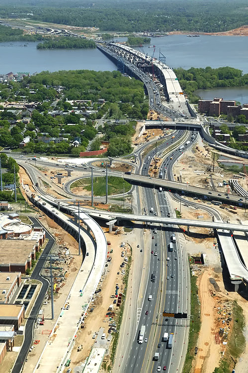
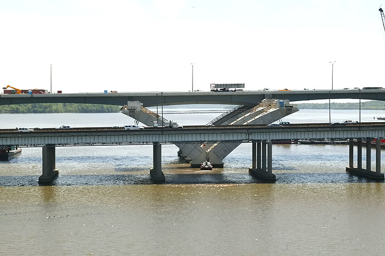
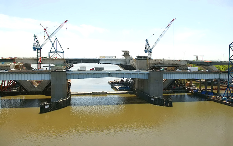
Potomac River Bridge construction, looking north. The existing Woodrow Wilson Bridge is behind the bridge under construction. |
 |
Potomac River Bridge construction, looking north. The existing Woodrow Wilson Bridge is behind the bridge under construction. |
 |
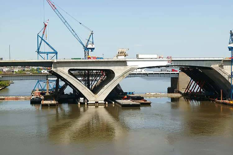
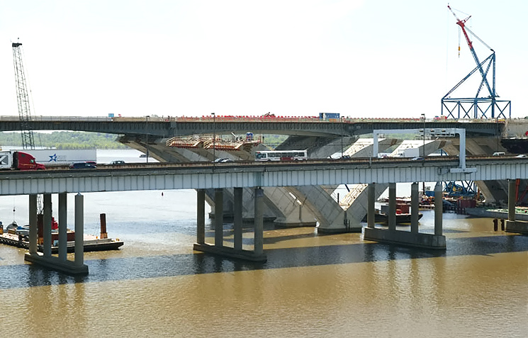
Potomac River Bridge construction, view of the Bascule Span construction, which is being built under the Potomac River Bridge Bascule Spans contract. The bascule leaves have been installed. The existing Woodrow Wilson Bridge is behind the bridge under construction. The new bascule span will have 70 feet of vertical navigational clearance when the drawspan is closed, 20 feet higher than the existing bridge's bascule span which has 50 feet of vertical navigational clearance when its drawspan is closed. |
 |
Potomac River Bridge construction, view of the Bascule Span construction,
and the Maryland Approach Spans construction,
which is being built under the Potomac River Bridge Maryland
Approach Spans contract. Delta pier construction is underway on
the bridge foundations. The foundations were
built in the Potomac River Bridge Foundations contract. Downtown Washington, D.C. is in the distance. Notice the airliner flying overhead on its final approach to National Airport 3 miles away. |
 |
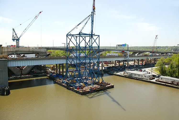
Potomac River Bridge construction, view of the Maryland Approach Spans
construction. Notice the ready-mix concrete trucks being carried by barge
to the bridge construction site. The next 3 photos gradually pan to the Maryland shore. |
 |
Potomac River Bridge construction, view of the Maryland Approach Spans construction. Notice the ready-mix concrete trucks being carried by barge to the bridge construction site. |
 |
Potomac River Bridge construction, view of the Maryland Approach Spans construction. |
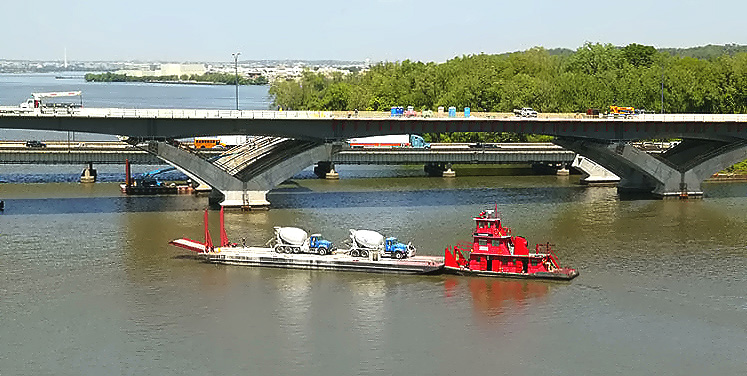 |
Potomac River Bridge construction, view of the Maryland Approach Spans
construction. Notice the ready-mix concrete trucks being carried by barge
to the bridge construction site. Downtown Washington, D.C. is in the distance. Notice the Washington Monument visible in the left of the photo. |
 |
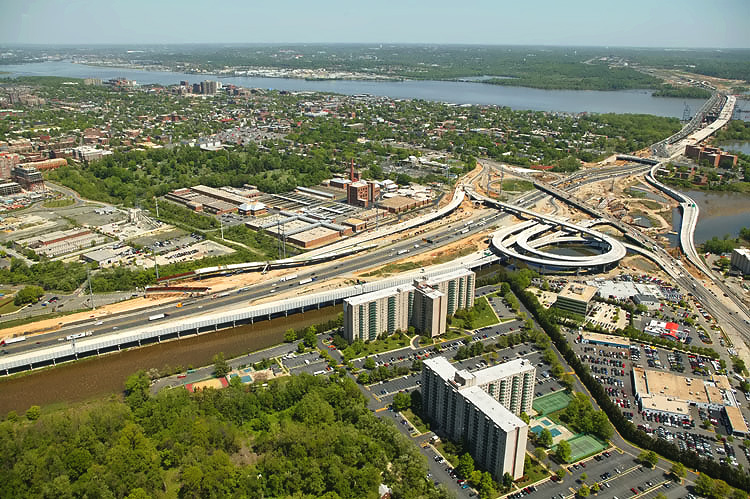
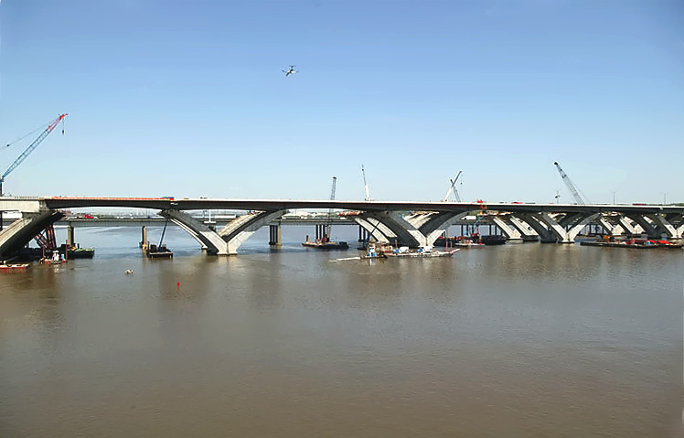
Interstate 295 Interchange construction, looking west along the I-95/I-495 Beltway. The Woodrow Wilson Bridge across the Potomac River is in the upper center part of the photo. |
 |
Woodrow Wilson Bridge
construction, looking west along the I-95/I-495 Beltway, from
Maryland to Virginia. This image is a zoom-in excerpt from the previous image, and is 705 kilobytes in size. |
 |
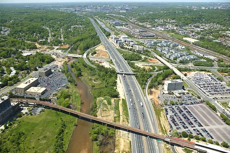
Interstate 295 Interchange construction, looking west along the I-95/I-495 Beltway. The Woodrow Wilson Bridge across the Potomac River is in the upper center part of the photo. I-295 curves over the Beltway on the two new bridges at the bottom, and I-295 terminates at MD-210 Indian Head Highway about a mile to the east. The new bridge to the left is a ramp that will connect the Beltway Outer Loop express roadway to I-295. |
 |
Woodrow Wilson Bridge construction, looking
west from Maryland to Virginia. This image is a zoom-in excerpt from the previous image, and is 684 kilobytes in size. |
 |
Interstate 295 Interchange construction, looking west along the I-95/I-495 Beltway. The Woodrow Wilson Bridge across the Potomac River is in the upper center part of the photo. I-295 curves over the Beltway on the two new bridges to the left, and I-295 terminates at MD-210 Indian Head Highway about a mile to the east. The two new bridges to the left are ramps connecting the Beltway Outer Loop to I-295. |
 |
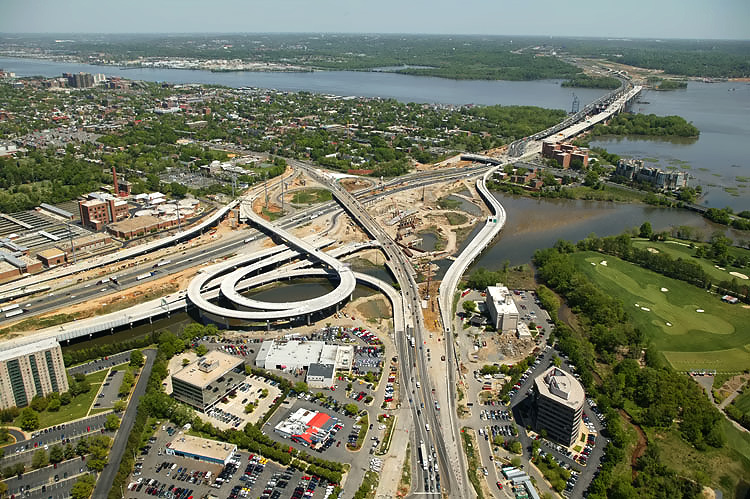
Interstate 295 Interchange construction, looking south. High capacity
roadways and ramps are being constructed to make this a 4-way interchange,
with the southerly extension heading into the National Harbor development
which began construction in 2004.
Website for National Harbor. |
 |
Interstate 295 Interchange construction, looking southeast. I-295 curves over the Beltway on the two new bridges to the left, and I-295 terminates at MD-210 Indian Head Highway about a mile to the east. |
 |
Interstate 295 Interchange construction, looking east along the I-95/I-495 Beltway. |
 |
Potomac River Bridge construction, looking south. The existing Woodrow Wilson Bridge is in front of the bridge under construction. |
 |
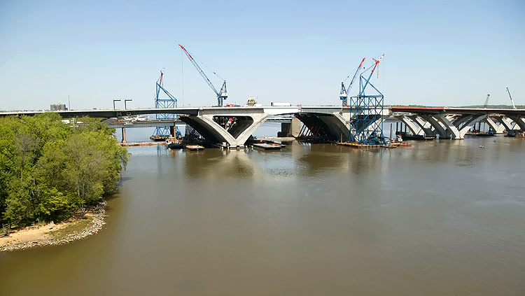
Potomac
River Bridge construction, looking south, view of the Maryland Approach
Spans construction, near the Maryland shoreline. The existing 6-lane Woodrow Wilson Bridge is visible on the near side of the new bridge construction. |
 |
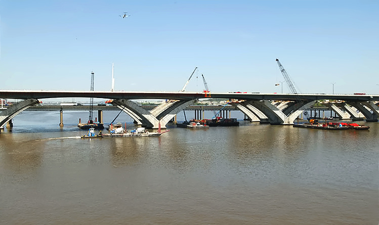
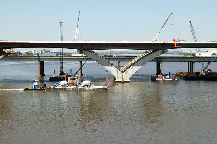
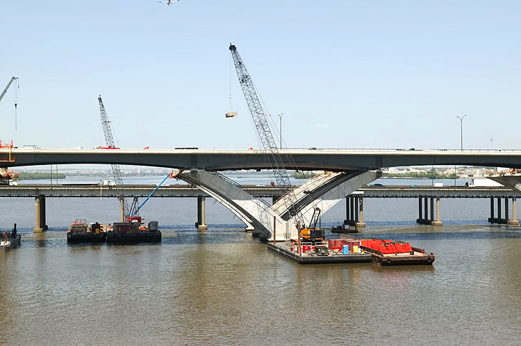
Potomac River Bridge construction,
looking south, view of the Maryland Approach Spans construction, which is
being built under the Potomac River Bridge Maryland Approach Spans
contract. The delta piers on the approach spans are being constructed via the precast segmental method, whereby reinforced concrete segments are fabricated in a fabrication yard, and assembled on the pier foundations and post-tensioned with steel cables that pass through channels in the piers. The arches are held in place by temporary steel cables until the reinforced concrete cross-member links the two arches. The bridge's steel beams and roadway deck will be constructed across the top of the piers. |
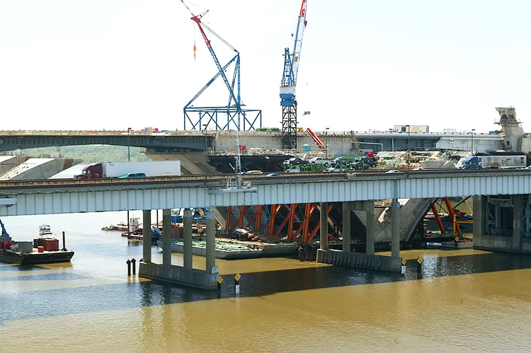 |
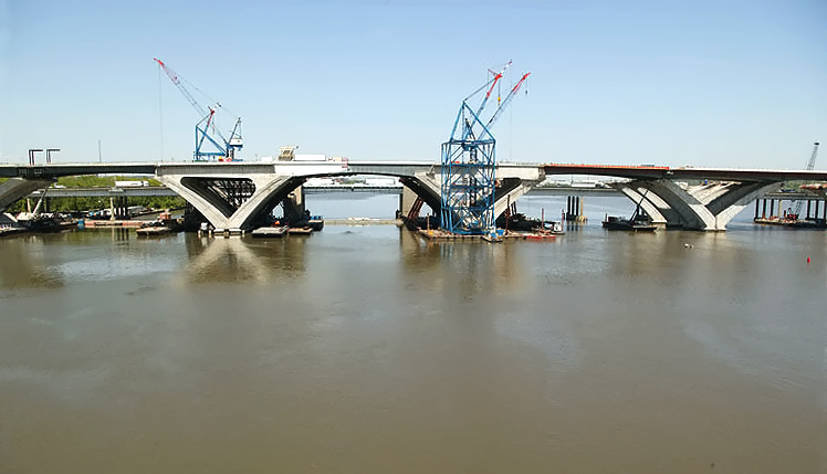
Potomac River Bridge construction, looking south, view of the Maryland Approach Spans construction and the Bascule Span construction. |
 |
Potomac River Bridge construction, looking south, view of the Maryland Approach Spans construction and the Bascule Span construction. |
 |
Potomac River Bridge construction, looking south, view of the Maryland Approach Spans construction. |
 |
Potomac River Bridge construction, view of the Bascule Span construction, which is being built under the Potomac River Bridge Bascule Spans contract. The existing 6-lane Woodrow Wilson Bridge bascule span is visible on the near side of the new bridge construction. |
 |
Construction of the Potomac River Bridge Virginia Approach Spans contract. The existing Woodrow Wilson Bridge is on the near side of the construction. Jones Point is visible in the upper center of the photo. |
Lead article - Woodrow Wilson Bridge Project Photos
This article was released on May 2, 2006, with the 17 photos, numbered 10 to 26 inclusive. The 16 photos, numbered 00 to 09 inclusive, and 27 to 32 inclusive, were added on May 20, 2006. The 22 photos, numbered 33 to 54, were added on June 1, 2006. Large zoom-in excerpt versions of numbers 28, 30, 41 and 42 were added on June 4, 2006.
Copyright © 2006 by Scott Kozel. All rights reserved. Reproduction, reuse, or distribution without permission is prohibited.
By Scott M. Kozel, Capital Beltway dot com, Roads to the Future
(Created 5-2-2006, updated 6-4-2006, moved to capital-beltway.com on 3-21-2007)