
| Springfield Interchange Project Photos - September 2005 |
The following 33 photos show various aerial views of the Springfield Interchange Improvement Project construction.
These photos were taken on September 27, 2005 by the Virginia Department of Transportation, and are posted here with their permission. Roads to the Future utilized PhotoDeluxe Business Edition to sharpen and brighten all of the photos. Click on the photo to get a large version of the photo. In later versions of Netscape and Internet Explorer, you probably will need to use Full Screen mode (the F11 key can be utilized to swap back and forth between Full Screen and Regular) to see the full size of the large photo without browser-induced image shrinkage. The large photos have sizes ranging from 181 to 253 kilobytes, with most of them being under 219 kilobytes. With a broadband or network Internet connection, each photo will download within seconds, but with a dial-up Internet connection it will be slower.
 |
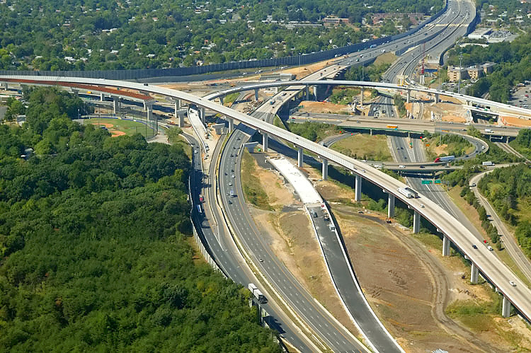
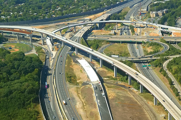
I-95/I-395/I-495 interchange construction, looking northeast. The Beltway (I-95/I-495 and I-495) runs left-right, and Shirley Highway (I-95 and I-395) runs upper-left to lower-right. The long elevated bridge is the 2-lane express flyover ramp from the Beltway Inner Loop (from Wilson Bridge) to I-95 south. The smaller elevated ramp that runs from left to right, connects I-395 to the Beltway Outer Loop (to Wilson Bridge), and this ramp opened to traffic on October 2, 2005. |
 |
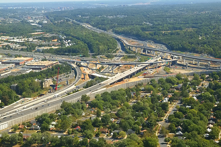
I-95/I-395/I-495 interchange construction, looking northeast. |
 |
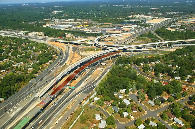
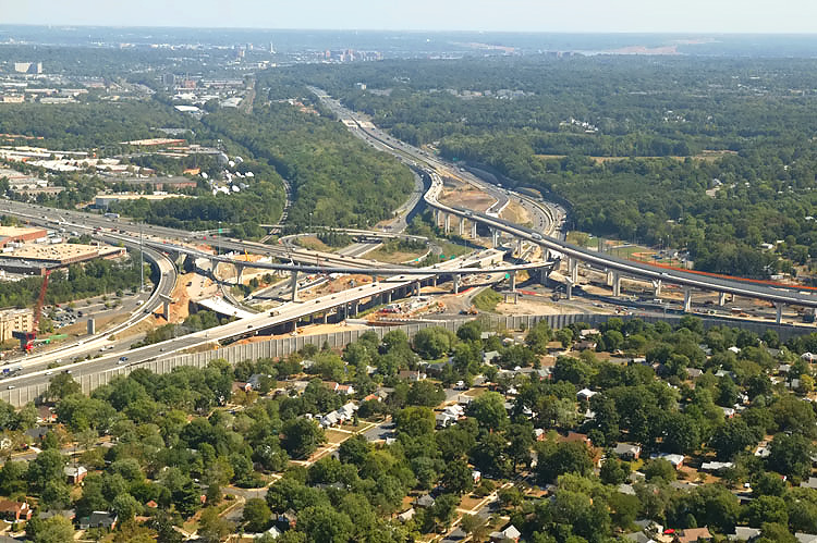
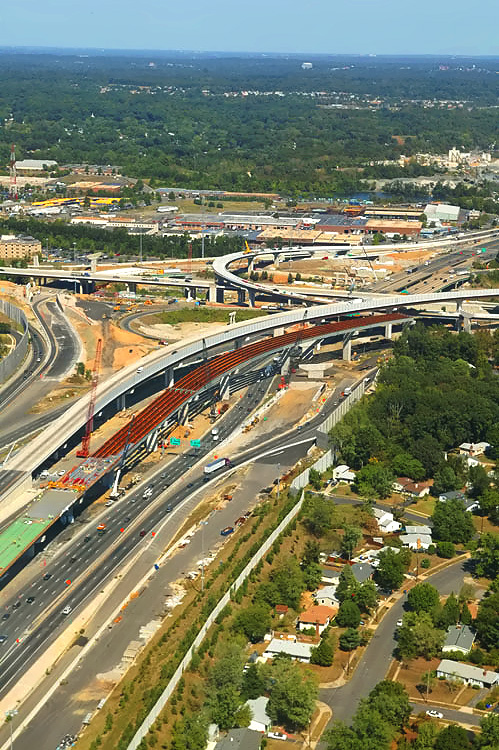
I-95/I-395/I-495 interchange construction, looking north. The red painted steel girders in the lower center of the photo, are for the under construction elevated bridge for the 2-lane express flyover ramp from I-95 northbound to the Beltway Outer Loop (to Wilson Bridge). |
 |
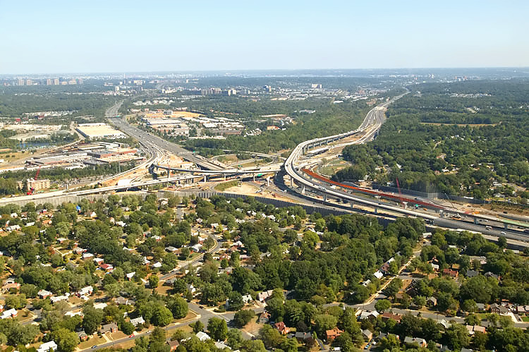
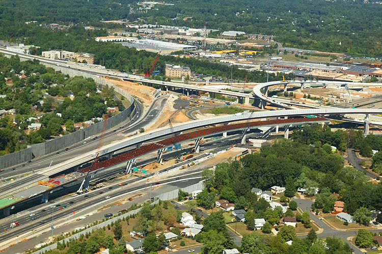
I-95/I-395/I-495 interchange construction, looking north. In the left of the photo, paralleling Shirley Highway, is the under construction 2-lane collector-distributor roadway carrying I-395 to I-95 at Springfield and Franconia via Route 644, and that roadway opened to traffic on October 4, 2005. |
 |
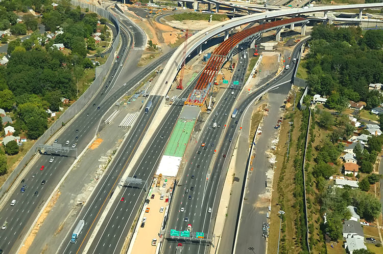
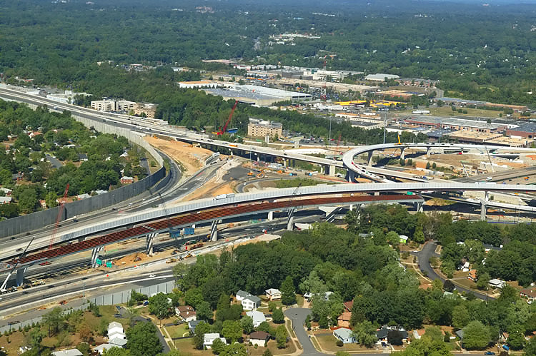
I-95/I-395/I-495 interchange construction, looking northwest. |
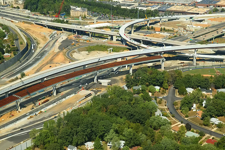 |
I-95/I-395/I-495 interchange construction, looking northwest. |
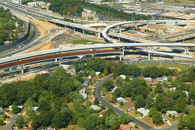 |
I-95/I-395/I-495 interchange construction, looking northwest. |
 |
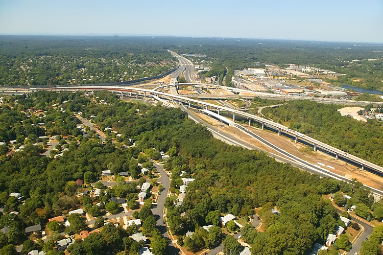
I-95/I-395/I-495 interchange construction, looking west toward Tysons Corner. |
 |
I-95/I-395/I-495 interchange construction, looking west toward Tysons Corner. |
 |
I-95/I-395/I-495 interchange construction, looking west toward Tysons Corner. |
 |
I-95/I-395/I-495 interchange construction, looking west toward Tysons Corner. The long elevated bridge is the 2-lane express flyover ramp from the Beltway Inner Loop (from Wilson Bridge) to I-95 south. The smaller elevated ramp that runs from right to left, connects I-395 to the Beltway Outer Loop (to Wilson Bridge), and this ramp opened to traffic on October 2, 2005. The red painted steel girders in the left of the photo, are for the under construction elevated bridge for the 2-lane express flyover ramp from I-95 northbound to the Beltway Outer Loop (to Wilson Bridge). |
 |
I-95/I-395/I-495 interchange construction, looking southwest. The Beltway runs left to right, and Shirley Highway runs lower-right to upper-left. The long elevated bridge to the left is the 2-lane express ramp from the Beltway Inner Loop (from Wilson Bridge) to I-95 south. The elevated one-lane ramp that curves upward from right to left, connects I-395 to the Beltway Outer Loop (to Wilson Bridge), and this ramp opened to traffic on October 2, 2005. |
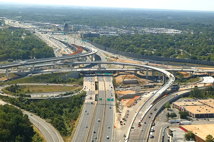 |
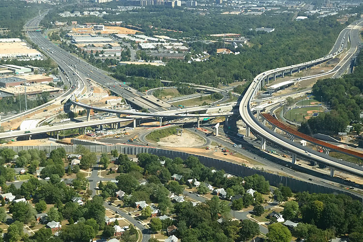
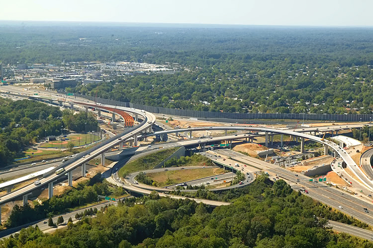
I-95/I-395/I-495 interchange construction, looking south toward Richmond. The Beltway runs left-right, and Shirley Highway runs up-down. Shirley Highway (I-95 south of the Beltway and I-395 north of the Beltway) has 3 mainline lanes each way and a 2-lane reversible roadway for high occupancy vehicle (HOV) traffic, and the reversible roadway is between the two general purpose roadways. The I-95/VA-644 interchange is in the distance. |
 |
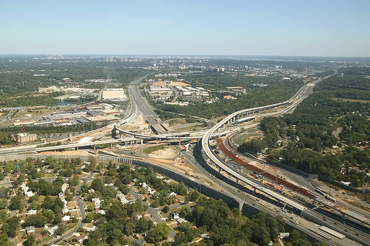
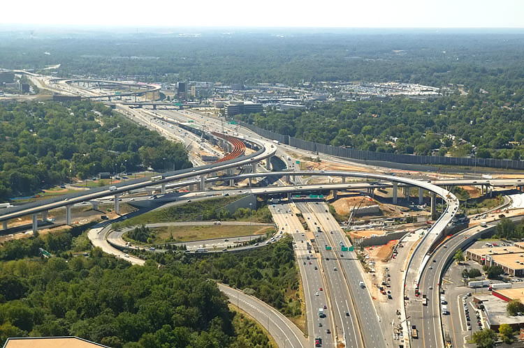
I-95/I-395/I-495 interchange construction, looking south. The Beltway runs left-right, and Shirley Highway runs up-down. The I-95/VA-644 interchange is in the distance. |
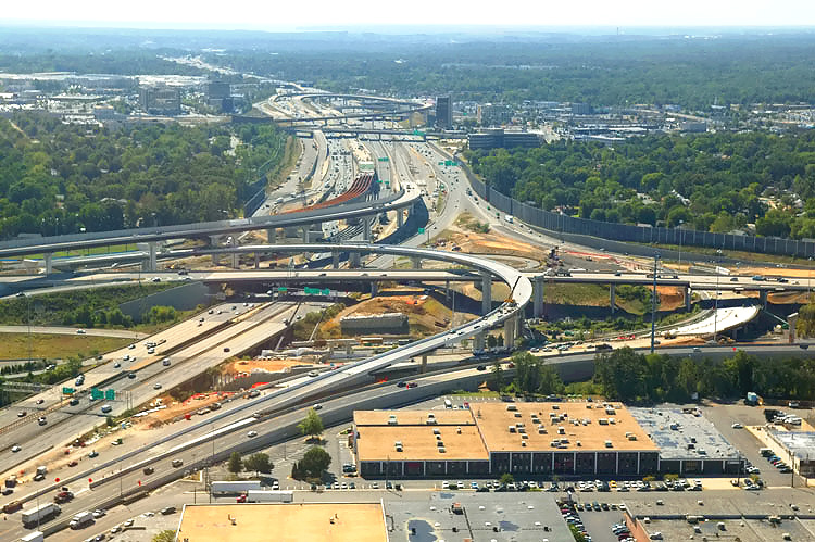 |
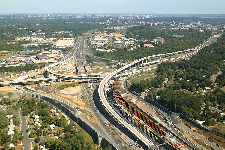
I-95/I-395/I-495 interchange construction, looking south. The Beltway runs left-right, and Shirley Highway runs up-down. The I-95/VA-644 interchange is in the distance. |
 |
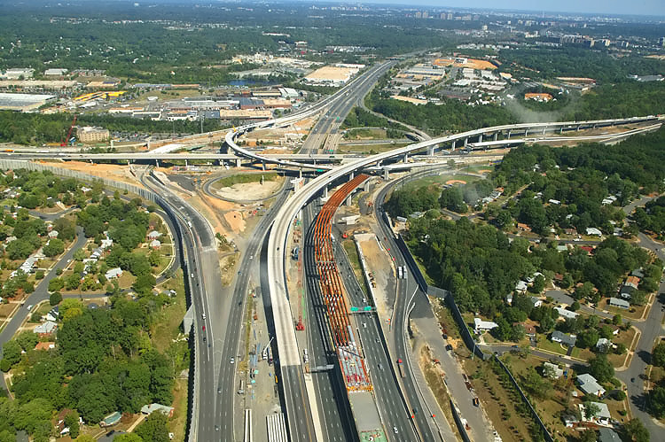
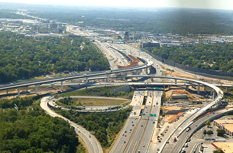
I-95/I-395/I-495 interchange construction, looking south. The Beltway runs left-right, and Shirley Highway runs lower-left to upper-center. The bridge over the Beltway Inner Loop for the 2-lane collector-distributor roadway that carries I-395 to I-95 at Springfield and Franconia via Route 644, is visible under construction in the right-center of the photo, and that roadway opened to traffic on October 4, 2005. |
 |
I-95/I-395/I-495 interchange construction, looking south. Similar vantage point to previous photo, but to the right. |
 |
I-95/I-395/I-495 interchange construction, looking south. Wide angle view. |
 |
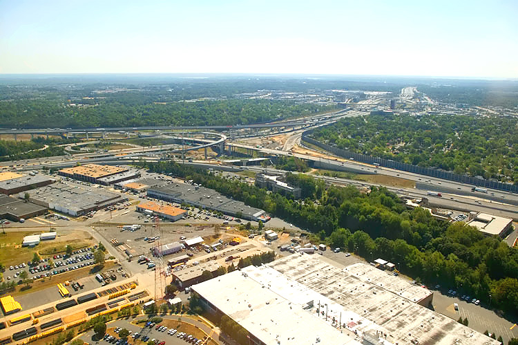
I-95/I-395/I-495 interchange construction, looking southeast. |
 |
I-95/I-395/I-495 interchange construction, looking northeast. The Beltway runs lower-left to top, and Shirley Highway runs left-right. The Beltway Outer Loop was realigned and raised onto a long bridge, to accommodate ramps to be built. The long elevated bridge (to the right) is the 2-lane express flyover ramp from the Beltway Inner Loop (from Wilson Bridge) to I-95 south. The one-lane flyover ramp from I-395 to the Beltway Outer Loop (to Wilson Bridge) is complete, and can be seen in the center of the photo. |
 |
I-95/I-395/I-495 interchange construction, looking northeast. |
 |
I-95/I-395/I-495 interchange construction, looking northeast. |
 |
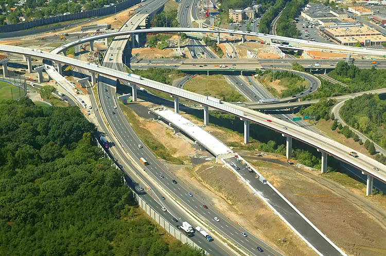
I-95/I-395/I-495 interchange construction, looking north toward Washington. The Beltway runs left-right, and Shirley Highway runs up-down. This photo was taken from approximately over the I-95/VA-644 interchange. The long elevated bridge is the 2-lane express flyover ramp from the Beltway Inner Loop (from Wilson Bridge) to I-95 south. The construction (the red steel beams) can be seen for the 2-lane flyover ramp from I-95 north to the Beltway Outer Loop (to Wilson Bridge). |
 |
I-95/I-395/I-495 interchange construction, looking north. The Beltway runs left-right, and Shirley Highway runs up-down. The long elevated bridge is the 2-lane express flyover ramp from the Beltway Inner Loop (from Wilson Bridge) to I-95 south. The construction (the red steel beams) can be seen for the 2-lane flyover ramp from I-95 north to the Beltway Outer Loop (to Wilson Bridge). The one-lane flyover ramp from I-395 to the Beltway Outer Loop (to Wilson Bridge) can be seen in the upper center of the photo. |
 |
I-95/I-395/I-495 interchange construction, looking northwest. |
 |
I-95/I-395/I-495 interchange construction, looking northwest. |
 |
I-95/I-395/I-495 interchange construction, looking west toward Tysons Corner. The long elevated bridge is the 2-lane express flyover ramp from the Beltway Inner Loop (from Wilson Bridge) to I-95 south. The smaller elevated ramp that runs from right to left, connects I-395 to the Beltway Outer Loop (to Wilson Bridge), and this ramp opened to traffic on October 2, 2005. |
 |
I-95/I-395/I-495 interchange construction, looking west toward Tysons Corner. Similar vantage point to previous photo, but to the right. The red painted steel girders in the left of the photo, are for the under construction elevated bridge for the 2-lane express flyover ramp from I-95 northbound to the Beltway Outer Loop (to Wilson Bridge). |
 |
I-95/I-395/I-495 interchange construction, looking west toward Tysons Corner. Similar vantage point to previous photo, but to the right. |
 |
I-95/I-395/I-495 interchange construction, looking southwest. The Beltway runs left to right, and Shirley Highway runs lower-right to upper-left. The long elevated bridge to the left is the 2-lane express ramp from the Beltway Inner Loop (from Wilson Bridge) to I-95 south. The elevated one-lane ramp that curves upward from right to left, connects I-395 to the Beltway Outer Loop (to Wilson Bridge), and this ramp opened to traffic on October 2, 2005. The construction (the red steel beams) can be seen for the 2-lane flyover ramp from I-95 north to the Beltway Outer Loop (to Wilson Bridge). |
 |
I-95/I-395/I-495 interchange construction, looking south toward Richmond. The Beltway runs left-right, and Shirley Highway runs up-down. Shirley Highway (I-95 south of the Beltway and I-395 north of the Beltway) has 3 mainline lanes each way and a 2-lane reversible roadway for high occupancy vehicle (HOV) traffic, and the reversible roadway is between the two general purpose roadways. The I-95/VA-644 interchange is in the distance. |
 |
I-95/I-395/I-495 interchange construction, looking south. The Beltway runs left-right, and Shirley Highway runs up-down. The I-95/VA-644 interchange is in the distance. Similar vantage point to previous photo, but to the right. |
 |
I-95/I-395/I-495 interchange construction, looking south. The Beltway runs left-right, and Shirley Highway runs up-down. The I-95/VA-644 interchange is in the distance. Similar vantage point to previous photo, but to the right. |
Lead article - Springfield Interchange Project Photos
Copyright © 2005 by Scott Kozel. All rights reserved. Reproduction, reuse, or distribution without permission is prohibited.By Scott M. Kozel, Capital Beltway dot com, Roads to the Future
(Created 11-1-2005, moved to capital-beltway.com on 3-16-2007)