
| Springfield Interchange Project Photos - May 2003 |
The following 12 photos show various aerial views of the Springfield Interchange Improvement Project (SIIP) construction.
These photos were taken on May 3, 2003, by the Virginia Department of Transportation, and are posted here with their permission. Roads to the Future utilized Adobe PhotoDeluxe Business Edition to sharpen and brighten all of the photos. Click on the photo to get a large version of the photo. In later versions of Netscape and Internet Explorer, you probably will need to use Full Screen mode (the F11 key can be utilized to swap back and forth between Full Screen and Regular) to see the full size of the large photo without browser-induced image shrinkage. The large photos have sizes ranging from 273 to 368 kilobytes, with most of them being under 305 kilobytes.
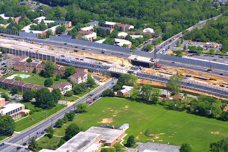 |
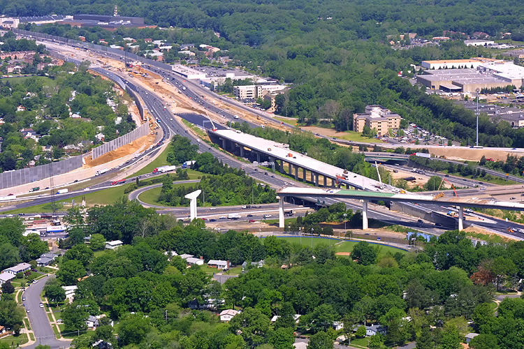
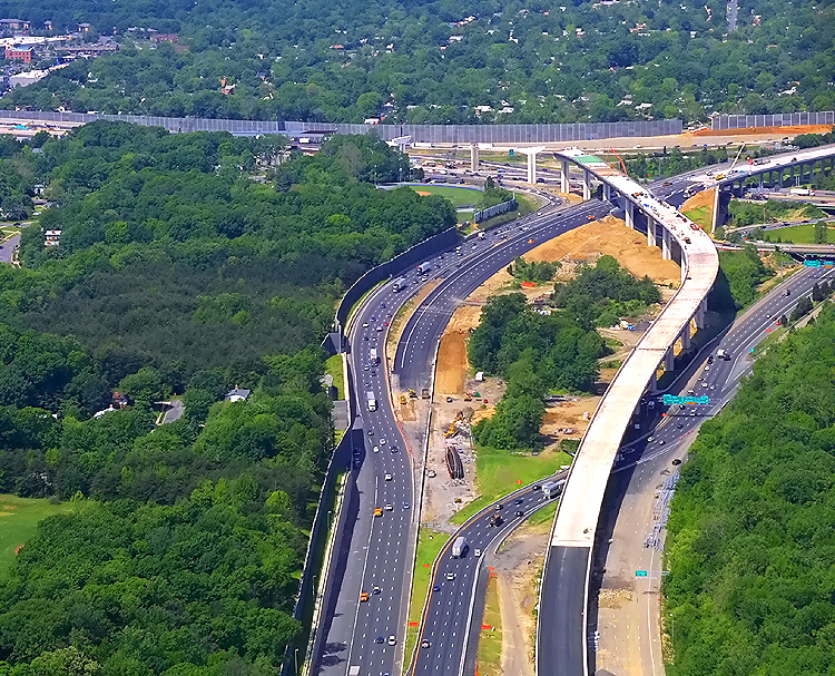
I-495 Capital Beltway passing over VA-617 Backlick
Road, this is just west of the Springfield Interchange construction. Looking
northwest. Phase 5 of the SIIP involved widening the Beltway west of I-95, relocating the Outer Loop of the Beltway in the I-95 interchange area, and realignment of the ramp from I-395 southbound to I-495 westbound, and widening the Capital Beltway from I-395 westward to near VA-620 Braddock Road. Phase 5 was placed under construction in August of 2001, and was completed in May 2004 at a cost of $95.5 million. Phases 4 and 5 of the SIIP included extensive construction of sound barrier walls along the western, southern and eastern edges of the interchange and approaches. Notice the sound barrier walls under construction along the edge of the Beltway. |
 |
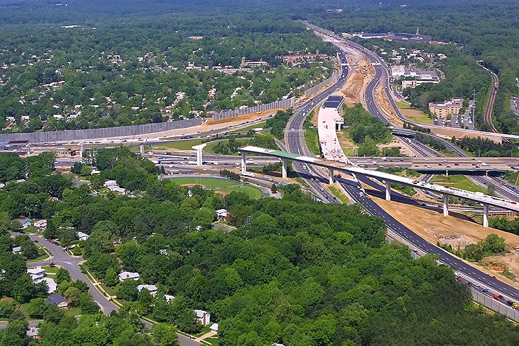
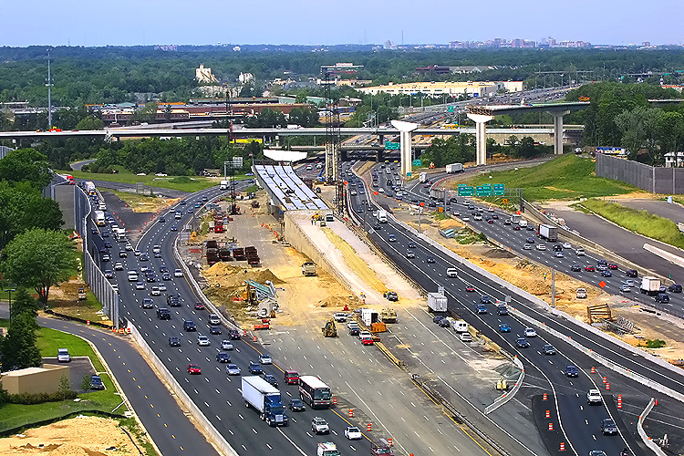
I-495
Capital Beltway passing over VA-617 Backlick Road, this is just west of the
Springfield Interchange construction. Looking north. Flanking roadways have
been built for the ramp highways to and from Shirley Highway, and mainline
Beltway traffic is temporarily operating there as the mainline Beltway roadways
and bridges are being demolished and reconstructed.
Shirley Highway is I-95 south of the Beltway, and is I-395 north of the Beltway. The Capital Beltway is I-495 throughout, and carries I-95 also east of Shirley Highway. |
 |
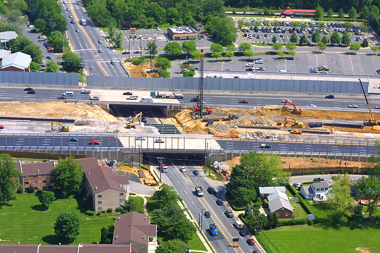
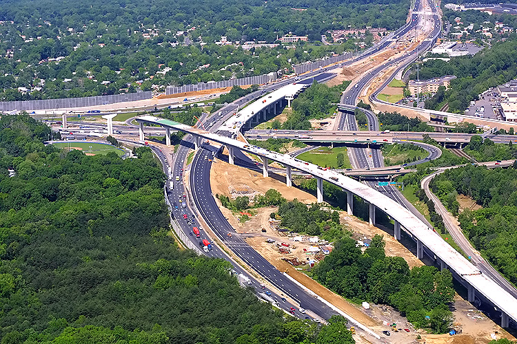
I-495
Capital Beltway passing over VA-617 Backlick Road, this is just west of the
Springfield Interchange construction. Looking eastward toward Shirley Highway. Flanking roadways have been built for the ramp highways to and from Shirley Highway, and mainline Beltway traffic is temporarily operating there as the mainline Beltway roadways and bridges are being demolished and reconstructed. Notice the sound barrier walls under construction along the edge of the interchange. |
 |
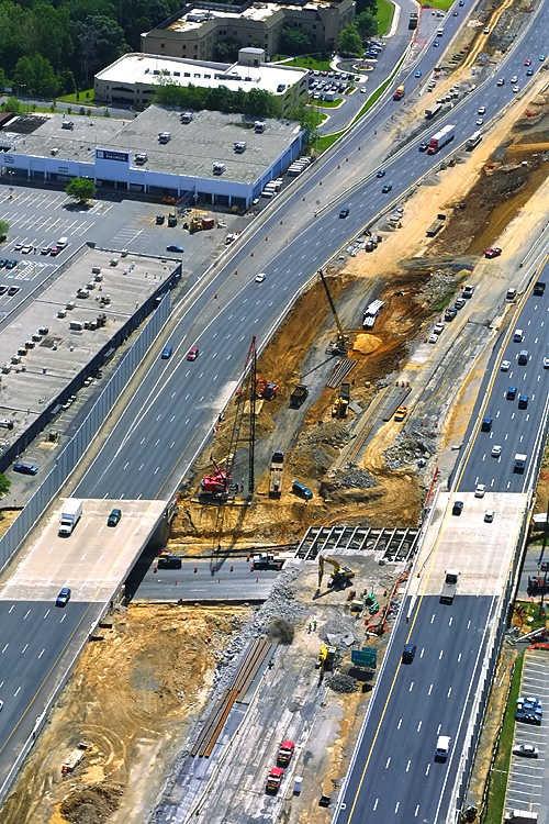
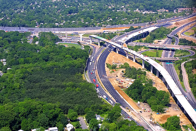
I-495
Capital Beltway, looking east from over VA-617 Backlick Road, eastward
toward Shirley Highway and the I-95/I-395/I-495 interchange.
Flanking roadways have been built for the ramp highways to and from Shirley Highway, and mainline Beltway traffic is temporarily operating there as the mainline Beltway roadways and bridges are being demolished and reconstructed. |
 |
I-95/I-395/I-495
interchange construction, looking northwest. The elevated ramp under construction
in the foreground is the B-610 bridge that will be the 2-lane express
flyover ramp (the I-95 southbound through route) from the Beltway Inner
Loop (from Wilson Bridge) to I-95 south.
The B-610 bridge is 4,870 feet long.
In the center of the photo is the B-613 bridge under construction that will be part of the relocated Beltway Outer Loop roadway. The B-613 bridge is 1,395 feet long. |
 |
I-95/I-395/I-495
interchange construction, looking west. The Beltway runs from lower right
to upper center, and Shirley Highway runs from left to right.
The elevated ramp under construction in the foreground is the B-610 bridge that will be the 2-lane express flyover ramp (the I-95 southbound through route) from the Beltway Inner Loop (from Wilson Bridge) to I-95 south. In the center of the photo is the B-613 bridge under construction that will be part of the relocated Beltway Outer Loop roadway. |
 |
I-95/I-395/I-495 interchange construction, looking west. The Beltway runs from lower right to upper right, and Shirley Highway runs from left to right. The elevated ramp under construction in the foreground is the B-610 bridge that will be the 2-lane express flyover ramp (the I-95 southbound through route) from the Beltway Inner Loop (from Wilson Bridge) to I-95 south. In the center of the photo is the B-613 bridge under construction that will be part of the relocated Beltway Outer Loop roadway. |
 |
I-95/I-395/I-495 interchange construction,
looking west, similar vantage point to
previous photo.
The Beltway Outer Loop roadway is being relocated in the interchange area, inboard of its original location to the west of the interchange, to provide roadside space for wide high capacity ramps to be built between the Outer Loop and Shirley Highway (I-95 and I-395), without needing expensive right-of-way acquisition of many adjacent homes and apartment buildings; and outboard of its original location to the east of the interchange, to provide median space for the pair of elevated ramps with the flyover bridges that connect the I-95 through traffic movements between the I-95/I-495 Beltway and I-95 Shirley Highway. |
 |
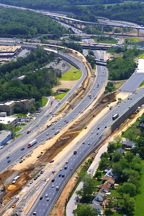
I-95/I-395/I-495 interchange construction, looking
west along the Beltway.
Notice at the bottom of the photo, the temporary roadway for the Beltway Inner
Loop which passes under the southbound I-95 flyover bridge under construction. About 1/4 of a mile of the Inner Loop roadway is being reconstructed for the transition to the flyover, and the temporary roadway is carrying the traffic while
the reconstruction is underway.
Phase 4 of the SIIP involved these three major portions: constructing the I-95 southbound roadway from the Capital Beltway to the VA-7900 Franconia-Springfield Parkway, constructing a 4,870-foot-long flyover bridge for traffic heading west on I-495 to I-95 south (the I-95 southbound through route), and widening the Capital Beltway from I-395 east to VA-613 Van Dorn Street. Phase 4 was placed under construction in November 2000, and was completed in October 2004 at a cost of $178.5 million. Phases 4 and 5 of the SIIP included extensive construction of sound barrier walls along the western, southern and eastern edges of the interchange and approaches. |
 |
I-95/I-395/I-495 interchange construction, looking
north (toward Washington) from over Springfield, along Shirley Highway (I-95 and I-395). The Beltway
runs left to right in the top of the photo. Southbound mainline roadways and
ramps have been relocated to provide space to build the southern part of the
2-lane express flyover ramp
(the I-95 southbound through route) under construction from the Beltway
Inner Loop (from Wilson Bridge) to I-95 south.
Notice the sound barrier walls under construction along the edge of the interchange. |
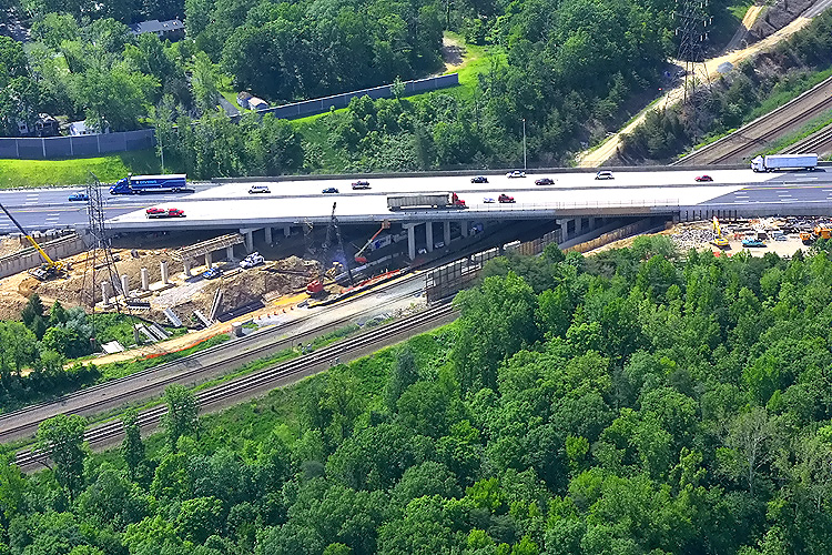 |
I-95/I-495 Beltway construction, widening the
east approach to the Springfield Interchange.
Looking south.
The bridge in the mainline of the Beltway, passes over the 2-track CSXT railroad mainline (which carries freight trains, Amtrak trains, and Virginia Railway Express commuter trains), and passes over the 2-track WMATA Metrorail Franconia/Springfield Route (Blue Line trains). The pre-existing pair of 4-lane bridges is being replaced by a pair of longer bridges that will each have 7 lanes. The new Outer Loop bridge has been constructed, and Beltway traffic is temporarily operating there with 4 lanes each way while the pre-existing Inner Loop bridge is demolished and a new Inner Loop bridge is being built. The replacement of these bridges was tedious due to railroad regulations that limited construction to only a few hours per day. The new bridge (B-635) has 4 spans, one over each railroad, and two to provide storm drainage. The B-635 bridge is 507 feet long. |
Lead article - Springfield Interchange Project Photos
Copyright © 2007 by Scott Kozel. All rights reserved. Reproduction, reuse, or distribution without permission is prohibited.By Scott M. Kozel, Capital Beltway dot com, Roads to the Future
(Created 5-19-2007)