
| Springfield Interchange Project Photos - June 2007 |
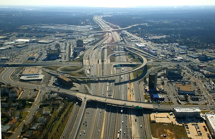
The following 11 photos show various views of the Springfield Interchange Improvement Project (SIIP), and they were taken from the top of the Burger King hi-rise building (see the tall building in lower right of this photo) which is on the northwest edge of the interchange between I-95 and VA-644 Old Keene Mill Road, in the Springfield urban area.
These photos were taken on June 13, 2007, by the Virginia Department of Transportation, and are posted here with their permission. Roads to the Future utilized Adobe PhotoDeluxe Business Edition to sharpen and brighten all of the photos. Click on the photo to get a large version of the photo. In later versions of Netscape and Internet Explorer, you probably will need to use Full Screen mode (the F11 key can be utilized to swap back and forth between Full Screen and Regular) to see the full size of the large photo without browser-induced image shrinkage. The large photos have sizes ranging from 200 to 260 kilobytes, with most of them being under 221 kilobytes.
 |
Looking
south along I-95 Shirley Highway toward Richmond, across the I-95/VA-644 interchange.
VA-644 is Franconia Road east of I-95 and is Old Keene Mill Road west of I-95. These photos pan in order, from the south, to the east, and to the north. |
 |
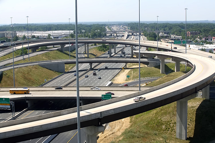
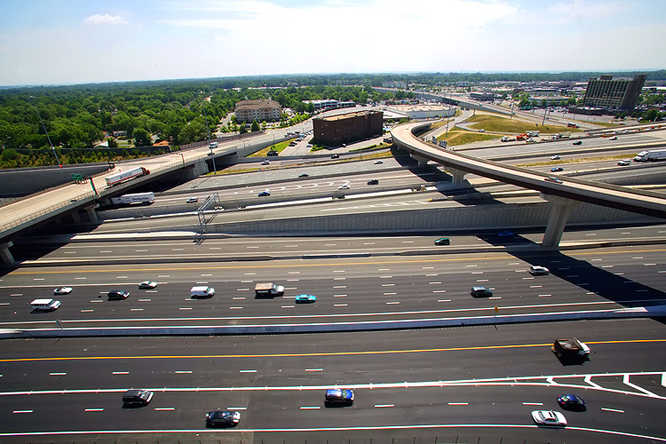
Looking south along I-95 toward Richmond, across the I-95/VA-644 interchange. The high flyover ramp that curves to the left, is the ramp from westbound VA-644 to southbound I-95. |
 |
Looking south along I-95 toward Richmond, across the I-95/VA-644 interchange. The high flyover ramp that curves to the left, is the ramp from westbound VA-644 to southbound I-95. |
 |
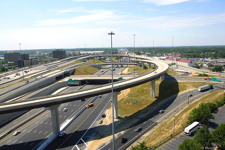
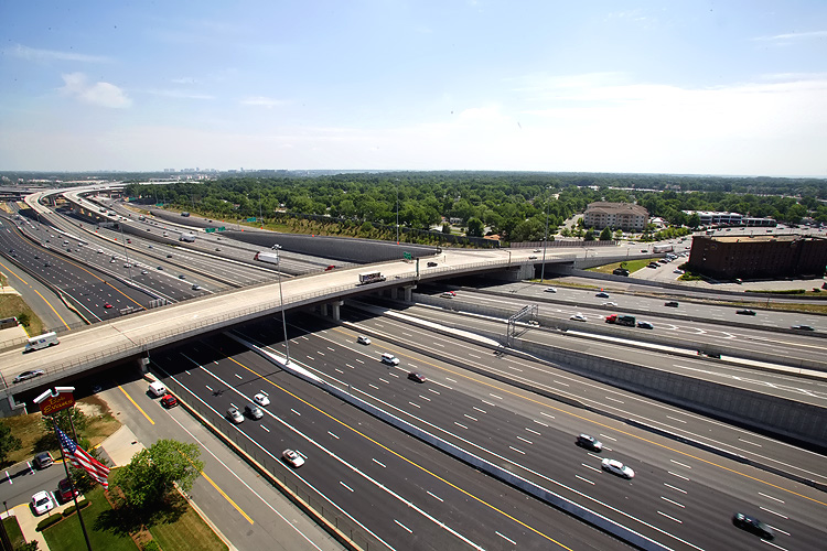
Looking across I-95 to the east. The flyover ramp to the right, is the ramp from westbound VA-644 to southbound I-95. The bridge to the left, is the 4-lane Commerce Street viaduct over I-95, which was built in the SIIP, and it is a modern 4-lane divided bridge with sidewalks on either side for pedestrians and bicycles. |
 |
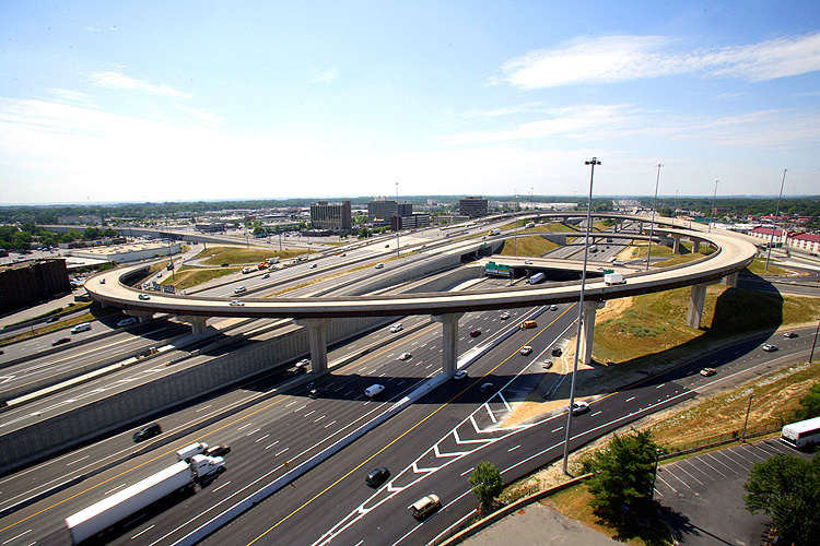
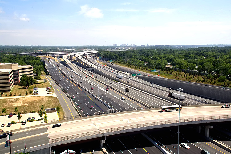
Looking along I-95 to the north toward Washington. The bridge to the center, is the 4-lane Commerce Street viaduct over I-95, which was built in the SIIP, and it is a modern 4-lane divided bridge with sidewalks on either side for pedestrians and bicycles. |
 |
Looking along I-95 Shirley Highway to the north toward Washington. |
 |
Looking
along I-95 Shirley Highway to the north toward Washington. The following photos
zoom in successively via more telephoto.
|
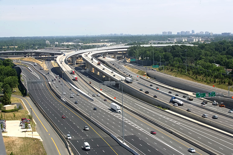 |
Looking along I-95 Shirley Highway to the north toward Washington. The ramps for the I-95/I-395/I-495 interchange are in the distance. |
 |
Looking along I-95 Shirley Highway to the north toward Washington. The ramps for the I-95/I-395/I-495 interchange are in the distance. The long elevated bridges between the center and upper right of the photo, are the 2-lane express flyover ramp from the I-95/I-495 Beltway Inner Loop (from Wilson Bridge) to I-95 Shirley Highway southbound, and the 2-lane flyover ramp from I-95 Shirley Highway northbound to the I-95/I-495 Beltway Outer Loop (to Wilson Bridge). |
 |
The long elevated bridges between the center and upper right of the photo, are the 2-lane express flyover ramp from the I-95/I-495 Beltway Inner Loop (from Wilson Bridge) to I-95 Shirley Highway southbound, and the 2-lane flyover ramp from I-95 Shirley Highway northbound to the I-95/I-495 Beltway Outer Loop (to Wilson Bridge). The left-curving elevated ramp in the upper center of the photo, is the 3-lane northbound flyover ramp from I-95/I-395 Shirley Highway northbound to the I-495 Beltway Inner Loop (toward Tysons Corner). |
 |
The long elevated bridge between the center and upper right of the photo, is the 2-lane express flyover ramp from the I-95/I-495 Beltway Inner Loop (from Wilson Bridge) to I-95 Shirley Highway southbound. |
Lead Capital Beltway dot com article -
Springfield Interchange Project Photos
Lead Roads to the Future article -
Springfield Interchange Project
Copyright © 2007 by Scott Kozel. All
rights reserved. Reproduction, reuse, or distribution without permission is prohibited.
By Scott M. Kozel, Capital Beltway dot com, Roads to the Future
(Created 7-28-2007)