
| Springfield Interchange Project Photos - January 2007 |
The following 25 photos show various aerial views of the Springfield Interchange Improvement Project (SIIP) construction.
These photos were taken on January 31, 2007, by the Virginia Department of Transportation, and are posted here with their permission. Roads to the Future utilized Adobe PhotoDeluxe Business Edition to sharpen and brighten all of the photos. Click on the photo to get a large version of the photo. In later versions of Netscape and Internet Explorer, you probably will need to use Full Screen mode (the F11 key can be utilized to swap back and forth between Full Screen and Regular) to see the full size of the large photo without browser-induced image shrinkage. The large photos have sizes ranging from 207 to 283 kilobytes, with most of them being under 237 kilobytes.
 |
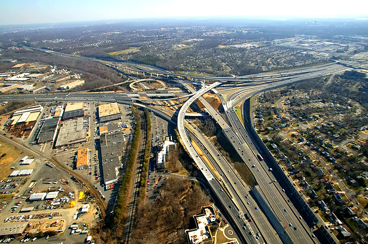
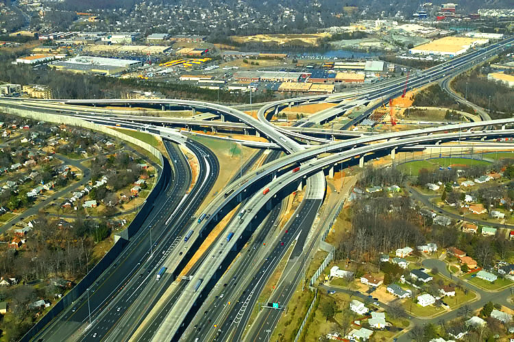
I-95/I-395/I-495 interchange construction, looking north toward Washington. The Capital Beltway (I-95/I-495 and I-495) runs right-left, and Shirley Highway (I-95 and I-395) runs bottom to top. The long elevated bridges between the center and upper right of the photo, are the 2-lane express flyover ramp from the Beltway Inner Loop (from Wilson Bridge) to I-95 southbound, and the 2-lane flyover ramp from I-95 northbound to the Beltway Outer Loop (to Wilson Bridge). The 3-lane northbound flyover ramp from I-95 northbound to the Beltway Inner Loop (toward Tysons Corner), was completed and opened to traffic on August 24, 2006, and that ramp runs from the center of the photo to the upper left. |
 |
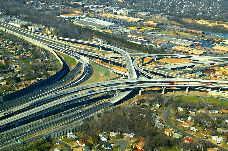
I-95/I-395/I-495
interchange construction, looking north.
This photo was taken from approximately over the
I-95/VA-644 interchange, and the I-95/I-395/I-495 interchange is in the distance.
The overpass bridge in the foreground is Commerce Street. The SIIP Project
included the replacement of the 2-lane Commerce Street viaduct over I-95,
with a modern 4-lane divided bridge with sidewalks on either side for pedestrians
and bicycles. Construction is underway to the lower left on the final roadway for southbound I-95. |
 |
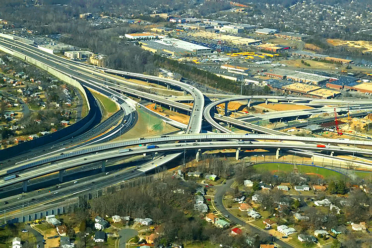
I-95/I-395/I-495
interchange construction, looking southwest. The 2-track mainline of the Norfolk
Southern Railroad can be seen, and in addition to freight trains it also carries
Virginia Railway Express (VRE) commuter rail trains.
The Capital Beltway (I-95/I-495 and I-495) runs
lower left to upper right, and Shirley Highway (I-95 and I-395) runs upper
left to lower right. The long elevated bridges in the left of the photo, are the 2-lane express flyover ramp from the Beltway Inner Loop (from Wilson Bridge) to I-95 southbound, and the 2-lane flyover ramp from I-95 northbound to the Beltway Outer Loop (to Wilson Bridge). |
 |
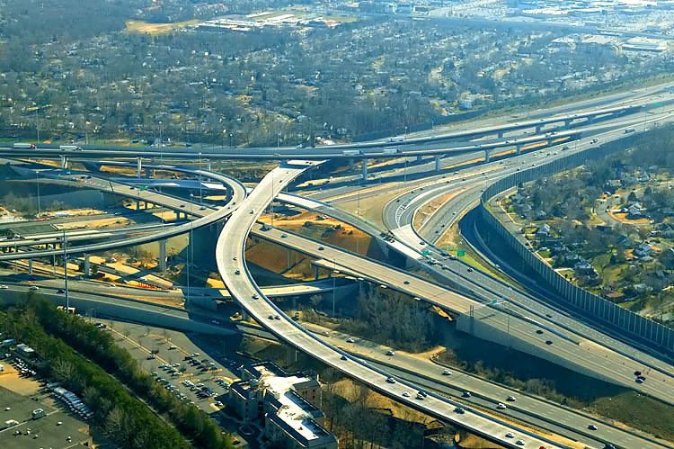
I-95/I-395/I-495 interchange construction, looking south toward Richmond. The Beltway runs left-right, and Shirley Highway runs up-down. Shirley Highway (I-95 south of the Beltway and I-395 north of the Beltway) has 3 mainline lanes each way and a 2-lane reversible roadway for high occupancy vehicle (HOV) traffic, and the reversible roadway is between the two general purpose roadways. The I-95/VA-644 interchange and the Springfield urban area is in the distance. |
 |
I-95/I-395/I-495 interchange construction, looking southeast. Shirley Highway runs left-right, and the Beltway runs lower right to upper left. The wide curving elevated ramp in the center of the photo, is the 3-lane northbound flyover ramp from I-95 northbound to the Beltway Inner Loop (toward Tysons Corner), which was completed and opened to traffic on August 24, 2006. |
 |
I-95/I-395/I-495 interchange construction, looking southeast. The wide curving elevated ramp in the center of the photo, is the 3-lane northbound flyover ramp from I-95 northbound to the Beltway Inner Loop (toward Tysons Corner). |
 |
I-95/I-395/I-495 interchange construction, looking east (toward Woodrow Wilson Bridge). The Beltway runs lower-left to upper left, and Shirley Highway runs left to right. The wide long elevated bridge in the left, is the 3-lane northbound flyover ramp from I-95 northbound to the Beltway Inner Loop (toward Tysons Corner). The 2-lane ramp from center to middle right, is the ramp connecting the Beltway Outer Loop directly to southbound I-95 (to Woodbridge), that opened to traffic on December 15, 2006. |
 |
I-95/I-395/I-495 interchange construction, looking east. |
 |
I-95/I-395/I-495 interchange construction, looking northeast. The Beltway (I-95/I-495 and I-495) runs upper center to left, and Shirley Highway (I-95 and I-395) runs lower right to upper center. The long elevated bridges in the right of the photo, are the 2-lane express flyover ramp from the Beltway Inner Loop (from Wilson Bridge) to I-95 south, and the 2-lane flyover ramp from I-95 north to the Beltway Outer Loop (to Wilson Bridge). The 3-lane northbound flyover ramp from I-95 northbound to the Beltway Inner Loop (toward Tysons Corner), runs from the center of the photo to the left. |
 |
I-95/I-395/I-495 interchange construction, looking northeast toward Washington. |
 |
I-95/I-395/I-495
interchange construction, looking north. The Capital Beltway (I-95/I-495 and
I-495) runs right-left, and Shirley Highway (I-95 and I-395) runs bottom to
upper right. The long elevated bridges between the center and upper right
of the photo, are the 2-lane express flyover ramp from the Beltway Inner Loop
(from Wilson Bridge) to I-95 southbound, and the 2-lane flyover ramp from
I-95 northbound to the Beltway Outer Loop (to Wilson Bridge).
The 3-lane northbound flyover ramp from I-95 northbound to the Beltway Inner Loop (toward Tysons Corner), was completed and opened to traffic on August 24, 2006, and that ramp runs from the center of the photo to the upper left. The 2-lane ramp from upper left to lower left, is the ramp connecting the Beltway Outer Loop directly to southbound I-95 (to Woodbridge), that opened to traffic on December 15, 2006. |
 |
I-95/I-395/I-495 interchange construction, looking north, across the length of the 3-lane northbound flyover ramp from I-95 northbound to the Beltway Inner Loop (toward Tysons Corner). |
 |
I-95/I-395/I-495 interchange construction, looking north, across the length of the 3-lane northbound flyover ramp from I-95 northbound to the Beltway Inner Loop (toward Tysons Corner). |
 |
I-95/I-395/I-495 interchange construction, looking southeast. The wide curving elevated ramp in the center of the photo, is the 3-lane northbound flyover ramp from I-95 northbound to the Beltway Inner Loop (toward Tysons Corner), which was completed and opened to traffic on August 24, 2006. |
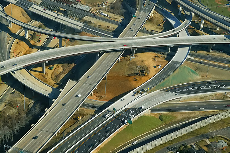 |
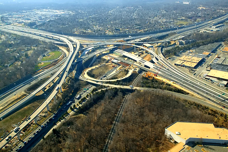
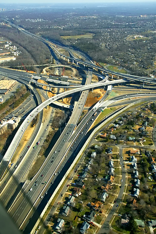
I-95/I-395/I-495
interchange construction, looking east. The roadways branching from the lower
left corner of the photo, are respectively, from left to right, the Beltway
Outer Loop roadway, the 2-lane relocated ramp from the Beltway Outer Loop
to northbound I-395 (this ramp is unopened but almost traffic-ready in this
photo), and the 3-lane ramp from the Beltway Outer Loop to southbound I-95
Shirley Highway (this ramp opened on December 15, 2006 and the left 2 lanes
are the express connection to I-95).
The bridged ramp running from right to left is the 3-lane northbound flyover ramp from I-95 northbound to the Beltway Inner Loop (toward Tysons Corner). The 4-lane roadway curving under the Beltway Outer Loop is the collector-distributor roadway that connects southbound I-395 and the Beltway Inner Loop, to the VA-644 interchange at Springfield for local traffic. |
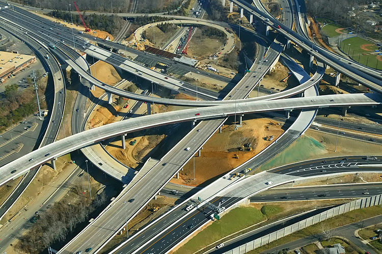 |
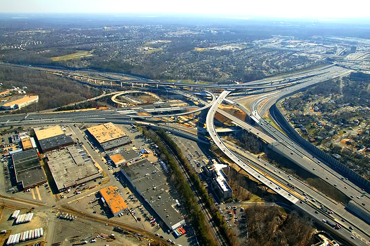
I-95/I-395/I-495
interchange construction, looking east. Similar vantage point to previous
photo. The Capital Beltway (I-95/I-495 and I-495) runs upper center to lower
left, and Shirley Highway (I-95 and I-395) runs center right to upper left. The abandoned loop ramp in the upper part of the photo, is the former 2-lane ramp from I-95 northbound to the Beltway Inner Loop (toward Tysons Corner). |
 |
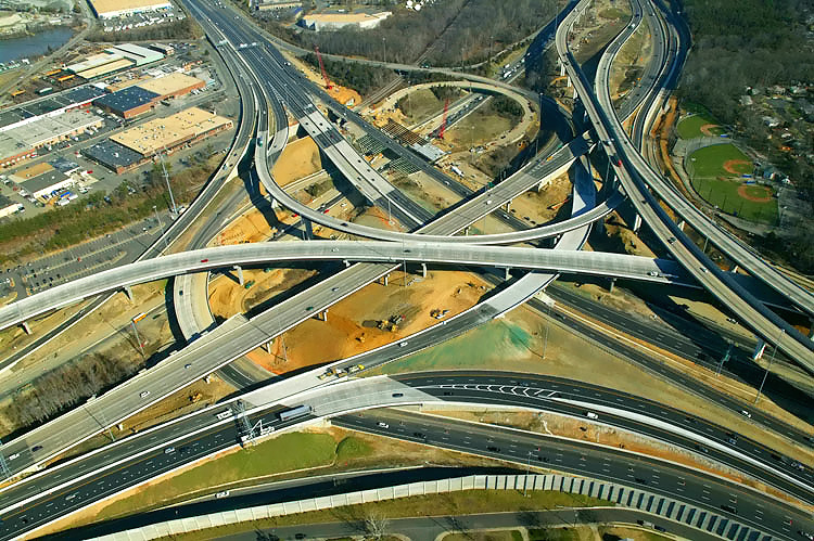
I-95/I-395/I-495 interchange construction, looking east. Similar vantage point to previous photo, but wider angle. The bridge under construction in the center of the photo, is the replacement bridge of northbound I-395 over the Beltway Inner Loop. |
 |
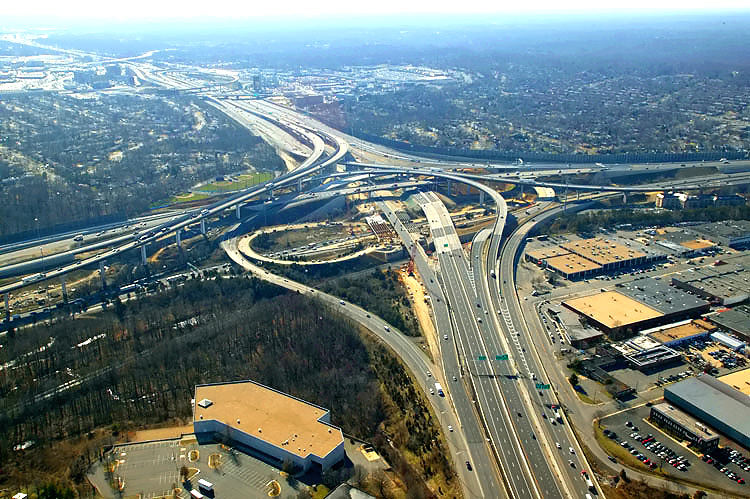
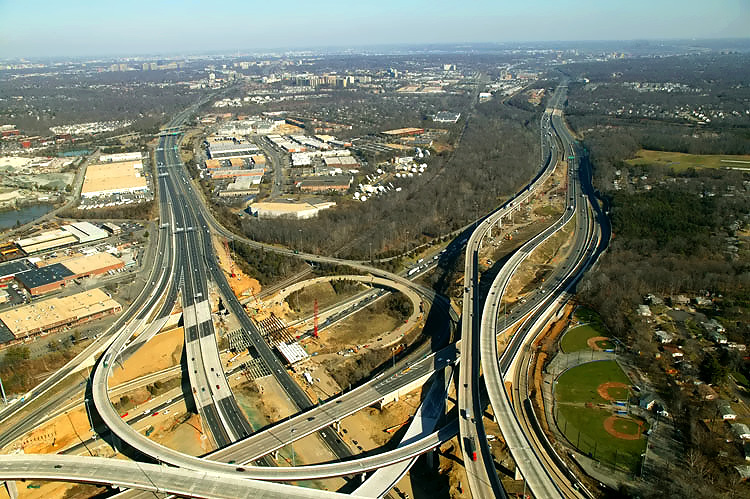
I-95/I-395/I-495
interchange construction, looking northeast. Similar vantage point to previous
photo. The ramp curving from the lower left to the lower right, is the 3-lane ramp from the Beltway Outer Loop to southbound I-95 Shirley Highway, and this ramp opened on December 15, 2006, and the left 2 lanes are the express connection to I-95 south. The long elevated bridges between the center right and upper right of the photo, are the 2-lane express flyover ramp from the Beltway Inner Loop (from Wilson Bridge) to I-95 southbound, and the 2-lane flyover ramp from I-95 northbound to the Beltway Outer Loop (to Wilson Bridge). |
 |
I-95/I-395/I-495 interchange construction, looking north toward Washington. The Capital Beltway (I-95/I-495 and I-495) runs upper right to lower left, and Shirley Highway (I-95 and I-395) runs bottom to top. |
 |
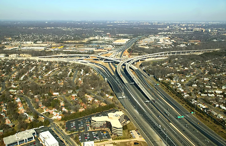
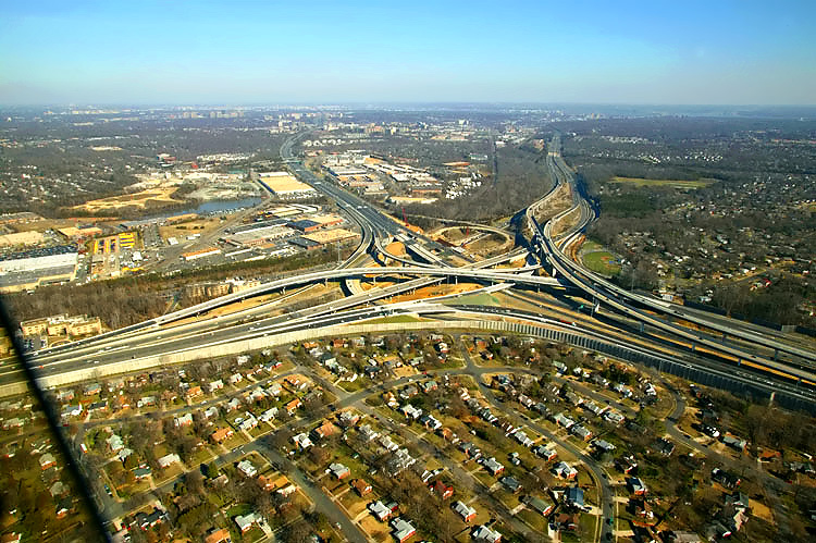
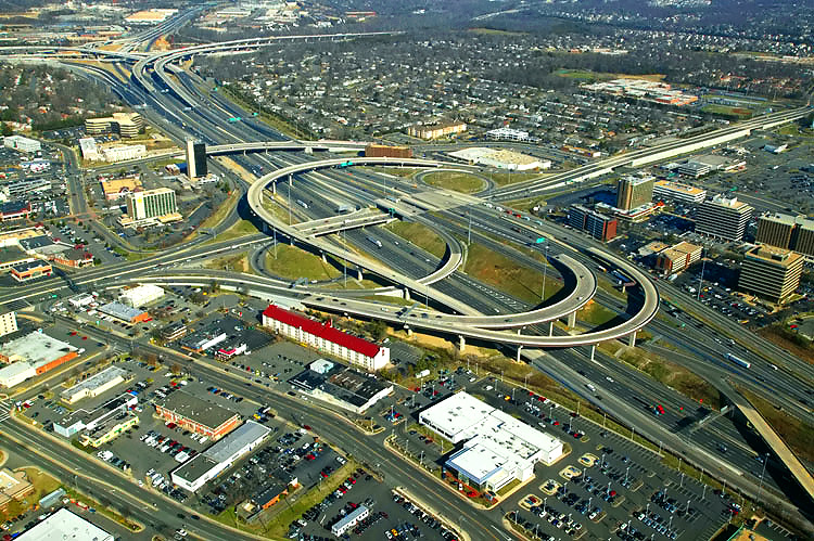
I-95/VA-644
interchange, looking east across the Springfield urban area. I-95 runs left-right,
and VA-644 runs lower-right to upper left. VA-644 is Old Keene Mill Road to
the west of I-95, and is Franconia Road to the east of I-95. The expansion of VA-644 Franconia Road near the Springfield Mall was part of the SIIP, and it included elevated 2-lane each way express roadways with the grade separation of two intersections, that over Loisdale Road and Frontier Drive, with outer local 3-lane each way VA-644 roadways intersecting the cross streets at grade. This section of VA-644 and the Mall is in the upper center of the photo, on the opposite side of I-95. The 4-lane Commerce Street crosses I-95 in the left of the photo. The urban overpass in the lower right of the photo, is Backlick Road passing over VA-644 Old Keene Mill Road. |
 |
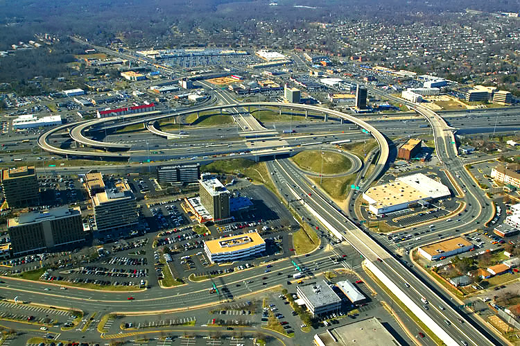
I-95/VA-644 interchange, looking north. I-95 runs lower right to upper left, and VA-644 runs left to right. The Beltway interchange (I-95/I-395/I-495) is visible in the distance. |
 |
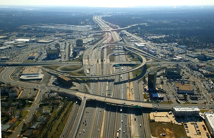
I-95/VA-644 interchange, (reconstruction completed except for I-95 southbound roadway which is part of Phase 6 & 7 now under construction), looking north toward Washington. I-95 runs bottom to top, and VA-644 runs left to right. The Beltway interchange (I-95/I-395/I-495) is visible in the distance. The 4-lane arterial which runs up-down along the left edge of the photo, is Backlick Road, and it has a grade separation over VA-644 Old Keene Mill Road. |
 |
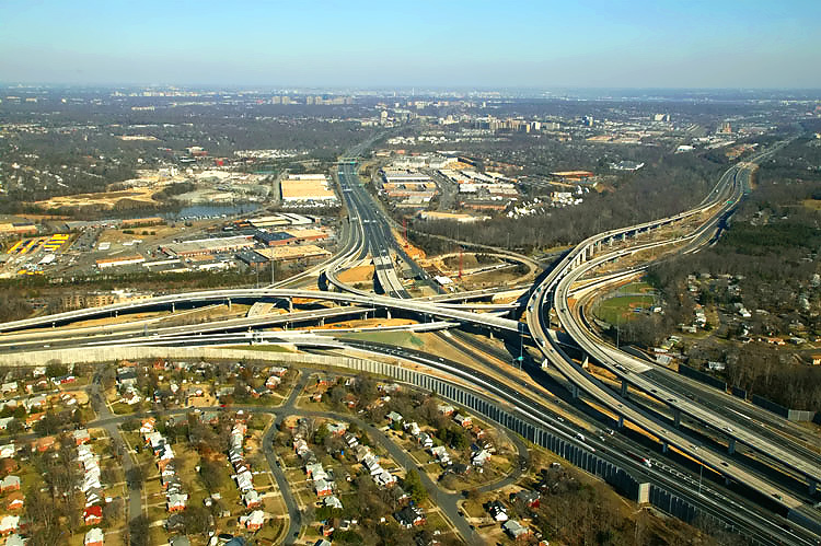
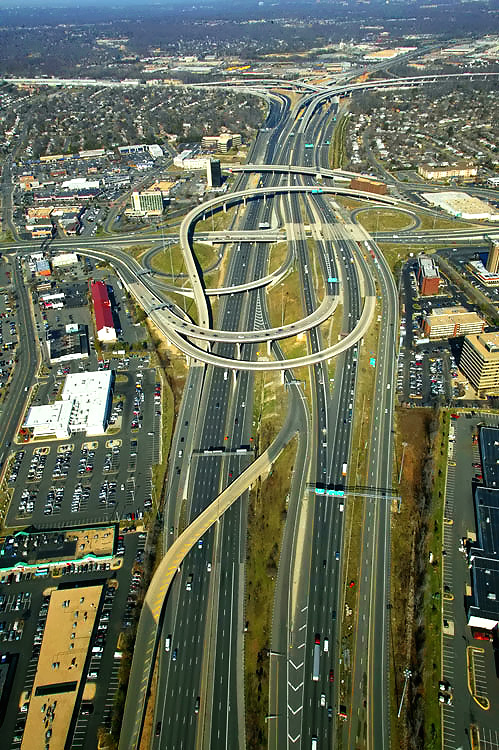
I-95/VA-644
interchange, looking west. I-95 runs left to right, and VA-644 runs bottom
to top. The expansion of VA-644 Franconia Road near the Springfield Mall was part of the SIIP, and it included elevated 2-lane each way express roadways with the grade separation of two intersections, that over Loisdale Road (visible in the lower right of the photo) and Frontier Drive, with outer local 3-lane each way VA-644 roadways intersecting the cross streets at grade. The 4-lane Commerce Street crosses I-95 in the right of the photo. |
 |
I-95/VA-644 interchange, looking southwest. I-95 runs upper-left to lower-right, and VA-644 runs lower-left to upper-right. The entire arc of the widened Commerce Street / Loisdale Road is visible in this photo. |
 |
I-95/VA-644
interchange, looking south toward Richmond. I-95 runs bottom to top, and VA-644
runs left to right.
The SIIP Project included the replacement of the 2-lane Commerce Street viaduct over I-95, with a modern 4-lane divided bridge with sidewalks on either side for pedestrians and bicycles; and that is the bridge crossing I-95 in the lower part of the photo. |
Lead article - Springfield Interchange Project Photos
Copyright © 2007 by Scott Kozel. All rights reserved. Reproduction, reuse, or distribution without permission is prohibited.By Scott M. Kozel, Capital Beltway dot com, Roads to the Future
(Created 2-15-2007, moved to capital-beltway.com on 3-16-2007)